

Volume 22, Issue 1, January 2026
The mantra for Geospatial AI must be only Trust, but verify
Dr. Mukund Kadursrinivas Rao
GNSS Constellation Specific Monthly Analysis Summary: December 2025
Narayan Dhittal
Is it possible to generate accurate 3D point clouds with UAS-LIDAR and UAS-RGB photogrammetry without GCPs?
Álvaro Gómez-Gutiérrez, Manuel Sánchez-Fernández, José Juan de Sanjosé-Blasco, Napoleón Gudino-Elizondo …

Geospatial technology is no longer confined to maps, layers, and overlays.
It is rapidly evolving into a living, reasoning system,
That observes, predicts, and decides.
As AI converges Earth observation, GIS, positioning, and analytics,
This delivers unprecedented scale, speed, and insight
While also introducing opacity, bias, and decision fatigue.
In an interview with Coordinates magazine,
Dr. Mukund Kadursrinivas Rao reminds us
That as …

says Dr. Mukund Kadursrinivas Rao in an interview with Coordinates magazine, as geospatial systems transition from mapping the world to autonomously reasoning about it.
Dr. Mukund Kadursrinivas Rao
is an internationally recognized leader in space and geospatial technologies, with deep multidisciplinary expertise spanning technology, applications and policies in Earth Observation (EO) and Geographic Information Systems (GIS). With …
February 2026
Geo Week
16 – 18, February 2026
Denver, CO, USA
www.geo-week.com
DGI 2026
23 -25 February
The Queen Elizabeth II Centre, London
https://dgi.wbresearch.com
March 2026
Munich Navigation Satellite Summit
25 – 27 March 2026
…
PointX and StellaX to smart lawn mowing
MOVA has integrated CHCNAV PointX integrated satellite ground service and the StellaX high precision positioning chip into its NAVAX 5000 AWD intelligent robotic lawn mower, unveiled at CES 2026. The integrated positioning solution is designed to support centimeter level accuracy for wire-free mowing, without requiring users to install …
SpaceX launches next-generation Italian COSMO-SkyMed satellite
The third satellite part of the COSMOSkyMed Second Generation (CSG) constellation, owned by the Italian Space Agency and the Italian Ministry of Defense, built by Thales Alenia Space, a joint venture between Thales (67%) and Leonardo (33%) and operated in orbit by Telespazio, a joint venture between Leonardo (67%) …
GNSS and PNT security deployed at World Economic Forum
Dimetor is providing its NAVSentry airspace situational awareness system to the World Economic Forum annual meeting, in support of the Austrian Armed Forces. The meeting is taking place this week in Davos, Switzerland, close to the Austrian border. NAVSentry is an AI-powered platform for detecting GNSS disruptions …
Vexcel UltraCam Osprey powers Espoo’s 3D city model
Vexcel Imaging highlights the City of Espoo, Finland, and its continued success in building one of Europe’s most advanced open 3D city models, powered by high-resolution nadir and oblique imagery captured with Vexcel’s UltraCam Osprey systems.
Espoo needed a highly accurate, photorealistic 3D model that would integrate …
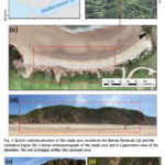
A case study on a beach and rocky cliff
Álvaro Gómez‑Gutiérrez
Instituto Universitario de Investigación Para el Desarrollo Territorial Sostenible, Universidad de Extremadura, Avda. de la Universidad S/N, 10003 Cáceres, Spain
Manuel Sánchez‑Fernández
Instituto Universitario de Investigación Para el Desarrollo Territorial Sostenible, Universidad de Extremadura, Avda. de la Universidad S/N, 10003 Cáceres, Spain
José Juan de Sanjosé‑Blasco
Instituto Universitario de Investigación …

The analysis performed in this report is solely his work and own opinion. State Program: U.S.A (G); EU (E); China (C) “Only MEO- SECM satellites”; Russia (R); Japan (J); India (I)
Narayan Dhital
Actively involved to support international collaboration in GNSS related activities. He has regularly supported and contributed to different workshops of the International Committee on …


 (5.00 out of 5)