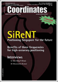
SiReNT – Positioning Singapore for the future SOH KHENG PENG, VICTOR KHOO HOCK SOON, LOH SOOK YEE
The benefits of three frequencies for the high accuracy positioning NOBUAKI KUBO, AKIO YASUDA, ISAO KAWANO TAKESHI ONO, CHIE URATANI
Demeter micro-satellite A K GWAL, BHISHEK SHRIVASTAVA AND KALPANA MALHOTRA
SDI: Lots of talk and little involvement ROGER LONGHORN

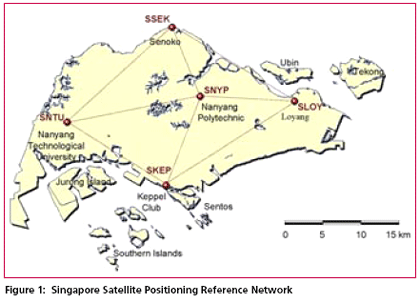
The Singapore Land Authority (SLA) will launch a new GPS reference station network in September 2006. The infrastructure known as the Singapore Satellite Positioning Reference Network (SiReNT) will replace the existing system, SIMRSN (Singapore Integrated Multiple Reference Station Network) which was developed in 2000 under a collaboration project between Nanyang Technological University (NTU), University of New South Wales (UNSW) and SLA.
Five Nation Consortium focuses on receivers for Galileo GPS system
British consultancy PA Consulting Group, London, is to lead a five nation consortium to look into the enabling technologies needed to develop receivers for Europe’s Galileo GPS location based system. The two year project, funded to the tune of Euros 6 million by the European Commission through grants from the sixth Framework Programme, is dubbed GREAT, for Galileo REceiver for the mAss market. The Consortium comprises Spanish group Acorde, a specialst in RF design for satellite and communications systems; German Aerospace Center DLR, the Tampere University of Technology, specifically the Finnish University’s group specializing in algorithm design for GNSS systems; and u-blox AG – a Swiss fabless developer and manufacturer of GPS chipsets and GPS receiver modules. The project will comprise three distinct phases – core technology development, prototyping and testing – achieving major blocks of demonstrable baseband IP that, the group says, will allow further developments to be kick-started. Initial target of the project is the development of front-end RF designs, as well as the algorithms and baseband technology to allow the Galileo signal to be used in indoor locations. www.eetimes.com

India cripples RTI act
The Union Cabinet on July 20 gave its approval for the introduction of a Bill amending the Right to Information Act, 2005, to exclude file notings in a few areas, in the monsoon session of Parliament. The proposed amendments would “remove ambiguities and make the provisions of the Act effective and progressive,” Information and Broadcasting Minister Priyaranjan Dasmunsi said. The decision follows objections from government organisations such as the Union Public Service Commission that detailed file notings at the Undersecretary and Joint Secretary level cannot be disseminated. “Such exemptions have been granted in the United States, United Kingdom and Australia,” Mr. Dasmunsi said.
Civil society organisations, which have been crucial in the enactment of the RTI Act, have reacted sharply to the decision. According to Aruna Roy of the Mazdoor Kisan Shakti Sanghathan, “Section 8 [exemption clause] is an overarching section. If there is a problem with file notings related to the UPSC, why doesn’t the Government put it under that schedule? This is a deliberate attempt to cover up for acts of corruption. There is fear among bureaucrats that the widespread use of the RTI legislation will end the arbitrary use of power. I really think this move will weaken the Act and the UPA’s promises of a free and accountable government.” However, the PMO clarifies that the controversy over the curtailment of the right to access file notings via the Right to Information Act seems to be misplaced. In fact, the so-called ‘striking down’ of the right to access notings on government files by the Union Cabinet, was actually what would allow access to file notings. PM Manmohan Singh’s office has issued an exhaustive clarification to point out that the changes were not ‘‘retrogressive’’ and the criticism was ‘‘misplaced’’ and based on ‘‘an incomplete knowledge of facts.’’

Raytheon completed preliminary test for GAGAN
Raytheon Company, UK successfully completed the Preliminary System Acceptance Test for the GPS Aided GEO Augmented Navigation- Technology Demonstration System (GAGAN-TDS). “This test was significant because the GAGAN-TDS ground elements supplied by Raytheon were installed and integrated ahead of schedule,” said Andy Zogg, Vice President of Raytheon’s Airspace Management and Homeland Security Business. “More importantly, the system functioned properly and exceeded the accuracy requirements.
The GAGAN-TDS network monitors the Global Positioning Satellite signals for errors and then generates correction messages to improve the accuracy of endusers’ position solution.
During the test period, average accuracy was better than one meter (3.3 feet) horizontally and only slightly more than one meter vertically, thus surpassing the 7.6 meter (25 feet) requirement by a significant margin. GAGAN-TDS is the first phase of a project sponsored by the Indian Space Research Organization (ISRO) and Airports Authority of India (AAI) to implement a space-based navigation system in Indian airspace. www.prnewswire.com

Google offers live traffic maps on cell phones
Google has announced that it is offering mobile phone users to view highway maps with live traffic data. Available initially in 30 U.S. cities, Google Maps for mobile will show traffic, with road conditions highlighted in three colors: red means congested, yellow & orange means slowdowns and green for open traffic. The service combines satellite imagery, directions, and traffic data – – completely free. One can check out the service by going to http://google. com/gmm on mobile phone. Currently,
it’s only available in the U.S. market.

Trimble tracks Galileo GIOVEA test satellite signal
Trimble has announced that it has successfully acquired and tracked the L1 BOC (1,1) Galileo GIOVE-A test satellite signal using a combined GPS, GLONASS, and Galileo prototype receiver. In addition to tracking the test satellite, Trimble has also announced that its Zephyr Geodetic II antenna is compatible with all current or planned GPS and GLONASS frequencies and the planned Galileo signals now. www.trimble.com

Galileo already over budget
Galileo Joint Undertaking, the organisation leading European development of a global satellite navigation system, has admitted it is already €404 million ($513 million) over budget, mainly due to miscalculating the cost of building and launching two technology pathfinder spacecraft, the first of which, GIOVE-A, was launched from Baikonur Cosmodrome in Kazakhstan in December. The total budget for the Galileo programme, which will comprise 30 operational satellites, will be about €4.5 billion, of which €1.5 billion has already been spent. Initially, a foursatellite constellation of operational spacecraft will be launched.
www.flightglobal.com


 (5.00 out of 5)