Sales contract from Cessna Aircraft Company to Leica
The Metrology Division of Leica Geosystems, Switzerland announced USA based Cessna Aircraft Company, a Textron company, has signed a sales contract for eight portable Leica Geosystems CMM systems used for industrial measurement and inspection. The acquisition consists of four Leica LTD840 Laser Trackers, and four Leica LTD640 Laser Trackers. Cessna is a manufacturer of general aviation airplanes. Leica Geosystems’ 3D coordinate measurement systems are used by manufacturers worldwide in the aerospace, automotive and shipbuilding industries. www.leica-geosystems.com
On Jan 10, India leaped high in space with the successful launch of its tenth Polar Satellite Launch Vehicle (PSLV-C7) that put …

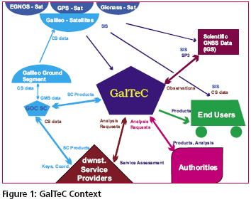
Today Satellite Based Navigation Services play an increasingly important role in modern society. The provision of the navigation, positioning and timing service provided by GPS is widely used. However, the system is under military control, and consequently legal guarantees of operation required by modern business cannot be given. On the other hand the market for GNSS related products is recognised as an important economic factor and service guarantees and liabilities will be needed.
I am an avid outdoor enthusiast and as such got a very simple GPS handset as a gift from a friend visiting me from abroad. This GPS can simply tell me my location in terms of latitude and longitude anywhere on earth. It can also help me trace back my route if I am lost in say a jungle or desert etc. The device is intended for use outdoors just for fun.
A few friends told me that apparently I need a license to use this device in India. I did some internet based research to find out the truth behind the matter and came across your magazine where you had printed an interview of Mr P K Garg, Wireless Adviser to Government of India, Wireless Planning and Coordination (WPC) Wing, Ministry of Communications and IT, Government of India. Although I was surprised to read that yes indeed I needed a license to operate the device in India, as confirmed by Mr Garg, being a law abiding citizen I decided I must acquire the license before operating it or at least apply for it. This started off a very frustrating process for me of trying to crack the bureaucracy which I am relating below in the hope that it will be read by someone who is authoritative enough to help me out.

The U.S. National Space Policy (NSP) was authorised by President Bush on August 31, 2006. This NSP establishes an overarching national policy that governs the conduct of U.S. space activities and supersedes the 1996 NSP.
The unclassified ten-page summary of the NSP consists of 13 self-contained sections including the principles, goals, guidelines (both general and specific to national security space, civil space and commercial space), international space cooperation, space nuclear power, radio frequency spectrum, orbital debris, effective export policies and space-related security classification.
January 2007
National Technical Meeting “GNSS Benefiting Mankind”
January 22-24, 2007, San Diego, CA
www.ion.org
Recent trends in infrastructure …

Location based services (LBS) are a rapidly growing field of wireless data services that can be accessed through a mobile phone equipped with a GNSS receiver. Some of the services are intended for outdoor use while others are suited for use in urban and indoor areas. It is therefore likely that subscribers will expect these services to be available throughout the coverage area of the mobile telephone network…

In 1900, the International Latitude Service started to monitor the wobbling and wandering of the North Pole. Since that year, the North Pole has been moving south. In everyday terminology, it has moved secularly on the Earth’s surface in the only direction it knows, i.e., south. The total motion has been about 13.5 meter over the past 100+ years, which in other words amounts to an amazing rate of 13 cm per year or about 1 cm per month…

This paper is an update of the GAGAN status presented at NSP meeting on May 8-19, 2006 held at Brussels, Belgium and also provides the future roadmap of the project. GAGAN will provide augmented information for satellite navigation to the aircraft flying within Indian Flight Information Regions (FIRs), which consists of seven boundaries. India is situated inthe vicinity of equator. In the equatorial region the ionospheric variations are very predominant…


 (5.00 out of 5)