In-Stat expects Chinese GPS handset market to grow rapidly
According to In-Stat, “the Chinese GPS phone market is still small and has low penetration, but its high growth rate is a clear signal of its development, as is the fact that it is starting to have an impact on the growth of the PND market”. The findings of this report shows shipments of GPS phones will exceed 5 million in 2009 and will account for about 10% of total mobile phone shipments in 2012, compared to 0.6% in 2007. In 2008, more mainstream handset manufacturers have begun GPS phone production, and the number of models available will be at least three times that of those in 2007.

Introducing GIS for IP based network alert notification
Desktop Alert Inc. a premier provider of network centric emergency mass notification systems to the US government pronounced that it has completed its GIS for implementation with the Desktop Alert Mass Notification System being the first such implementation worldwide. It employs industry standards for GIS mapping systems. The new product has been built on using AJAX technologies along with detailed street and aerial imagery data, and an open API. It allows customization of the map output along with the ability to add situational awareness and response capabilities using application-specific data to the map. www.desktopalert.net

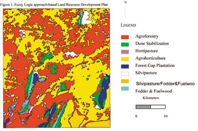
The present study aims at developing a generic automated methodology for addressing Multi-Objective Multi- Criteria Decision-Making problems. Scientific approach which make use of analytical modeling techniques are essential to suggest suitable changes in land use and to generate action plan for an area for land and water resource development. This problem can be cast into a multi-objective multicriteria decision-making problem…
China is set to prove its determination for rapid development.
Olympic is not the sole reason but is otherwise also.
It seems to be backed by a vision and action plans.
One one hand we can see the massive infrastructure …

Synchronet – an innovative system
Franco Gottifredi, Monica Gotta, Enrico Varriale, Daniele Cretoni
High Resolution Satellite Imagery (HRSI) replace Aerial Photography?
Shunji Murai
Role of Photogrammetry and Remote Sensing in Wenchuan Earthquake
Deren Li
3D mapping from space?
Prof Dr Armin Gruen, Dr Kirsten Wolff
My experience with GPS licensing
Manvendra

Boeing considering submitting bid for EU’s Galileo project
Boeing Co is considering submitting a bid in the forthcoming tender for EU’s Galileo satellite navigation project, Handelsblatt said, citing a Boeing spokeswoman. Handelsblatt said Boeing is interested in participating in the tender for 26 position satellites, which make up one-third of the overall budget for the estimated 3.4 billion euros Galileo project. The Galileo project would be divided into six segments — satellites, launchers, computer programmes, ground stations, control stations and system operation. EU officials have previously said the European Commission and the European Space Agency would launch public tenders by the middle of this year, with a view to first contracts being signed before 2009.http://www.hemscott.com/news/
PhotograPhy happens to be my current favourite hobby. Recently I developed interest in geocoding my photographs. By geocoding photographs you can associate a geographical location with the photograph. This involves putting the latitude, longitude and altitude in the photographs EXIF tags. Exchangeable image file format (Exif) is a specification for the image file format used by digital cameras. This is trivial if you use a GPS receiver. Last year, I had succeeded in making necessary interface to my Nikon D200 camera with a GPS receiver.

GPS system used to slow speeding cars
Cars will be fitted with test systems which tell drivers of speed limits and reduce vehicle speeds if they fail to slow down, as part of a new road safety trial in NSW, Australia. It will be a $1 million, 18-month trial involving 100 cars. The cars will be fitted with GPS devices. It will also warn drivers if they are speeding. In addition, 40 of the cars will be fitted with separate technology limiting fuel to the engine if a driver fails to slow down, automatically forcing a reduction in the car’s speed. http://news.theage.com.au

Credent aids in Myanmar’s cyclone relief work
img23
After NARGIS cyclone hit Myanmar and took the lives of about 100,000, an estimated 1.5 million victims are trying to survive in midst of chaos. Credent plans to extend assistance in the cyclone affected regions by providing the related map data from available resources including local organizations and the web. The development of the maps and GIS data is currently under Credent expense. To strengthen the provision of this vital information, any funding received will greatly improve the speed of the work. www.credent-asia.com/


 (5.00 out of 5)