

Geospatial AI to address climate change
IBM has released its latest geospatial artificial intelligence (AI) initiative to address climate change. These efforts involve collaborations across various regions and uses advanced AI models designed for geospatial applications.
Central to these initiatives is IBM’s geospatial foundation model, developed jointly with NASA. These models aim to generate environmental insights and …
Ireland successfully launches its first satellite into space
EIRSAT-1, a student-built satellite from University College Dublin, has been successfully launched into space, officially becoming Ireland’s first-ever satellite.
The miniature cube satellite, or cubesat, designed, built, and tested at UCD under guidance of the European Space Agency (ESA), took flight at the Vandenberg Space Force Base …

The study provides an overview of contributions made so far on land information management systems, with the sole purpose of ascertaining the progress recorded and inherent challenges to the existing system.
Ifeanyichukwu Valentine Nwafor
Department of Estate Management, University of Nigeria
Raphael Oshiobugie Sado
epartment of Estate Management, Nnamdi Azikiwe University, Awka
Inipami Prince Johnni
Abstract
The need to improve on a …
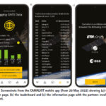
This paper presents results from data collection campaigns using the CAMALIOT mobile app.
Linda See
Novel Data Ecosystems for Sustainability Research Group, International Institute for Applied Systems Analysis (IIASA), Laxenburg, Austria
Benedikt Soja
Institute of Geodesy and Photogrammetry, ETH Zurich, Zurich, Switzerland
Grzegorz Kłopotek
Institute of Geodesy and Photogrammetry, ETH Zurich, Zurich, Switzerland
Tobias Sturn
Novel Data Ecosystems for Sustainability Research Group, International …

Volume XIX, Issue 11, November 2023
Land Administration and Geospatial Information Hard Talk: A Critical Evaluation
Anthony Beck, Vladimir V. Evtimov and Keith Clifford Bell
Understanding the RINEX format for GNSS data transfer and storage
Volker Janssen
The ubiquitous dimensions of Surveying and Mapping deliverables in Nigeria
Pepple, G. T., Udoh, O. J., …

As the world rages with debate,
About who is right,
And whose rights are endangered,
There unfolds a ‘humanitarian catastrophe’…
The death toll is mounting…
Where even babies have become most unfortunate victims,
Who are symbols of hope and happiness,
Who don’t and can’t take sides.
Humanity is paramount…
It must prevail!
Bal Krishna, Editor
bal@mycoordinates.org
Tweet
February 2024
Geo Week 2024
11 – 13 February
Denver, CO, USA
https://www.geo-week.com
MENA Geospatial Forum
14 – 15 February 2024
Dubai, UAE
https://menageospatialforum.com
March 2024
Geo Connect Asia
06 – 07 March 2024
Singapore
https://www.geoconnectasia.com
DGI 2024
11 – 13 March
…
Trimble introduces MPS566 Modular GNSS heading receiver
Trimble has announced its next generation GNSS receiver for marine construction and drilling and piling operations— the Trimble MPS566 Modular GNSS heading receiver. With built-in dual GNSS antenna ports and constellation-agnostic Trimble ProPoint™ technology, the MPS566 delivers highly accurate positions and orientation for work that demands precise heading. With …
UP42, GLOBHE sign partnership
UP42 and GLOBHE have announced their partnership to make high-quality drone data available through UP42. GLOBHE relies on 9500+ local professional drone operators in 142 countries and is the sole drone marketplace platform to support automated data collection at a global scale for sustainable infrastructure, environmental and humanitarian purposes. https://up42.com
Remotely fly X10 …


 (5.00 out of 5)