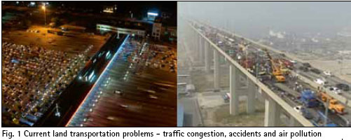
During the last half century, countries all over the world went through a remarkable economic growth, which resulted in higher income levels and changes in people’s way of living. In particular, transportation industry has undergone a dramatic change. The number of privately owned cars has explosively increased to facilitate individuals’ travel. Volume of goods transportation also rose sharply due to expanding global trade and online commerce…

Volume VI, Issue 7, July 2010
Zip
Transport planning in Korea
Eunsung Lee, Jae-Ik Park, Jung-Ho Cho, Moon-Beom Heo, Woo-Yong Kang
PNDs and smartphone navigation both will have its place
Jörn Watzke
Integration in a receiver position computation
Filipo Rodriguez, Gian Paolo Plaia
Need for comprehensive urban information system
Prof P Misra
My Coordinates
EDITORIAL
His Coordinates
Sanjai Kohli
News
INDUSTRY | GPS | …

INDUSTRY | LBS | GPS | GIS | REMOTE SENSING | GALILEO UPDATE
Leica releases MobileMatriX 4.0, updates GMX902 family
Leica MobileMatriX 4.0 supports the new Leica Viva GNSS series, as well as L1 and L1/L2 Post-Processing, Microsoft Windows 7 and many other improvements. It is an advanced solution for mobile GIS applications in combination with …

INDUSTRY | LBS | GPS | GIS | REMOTE SENSING | GALILEO UPDATE
Nokia and CE4A release Terminal Mode Specs
Nokia and CE4A (Consumer Electronics for Automotive) working group have released the Terminal Mode technology specification as a proposed industry standard for the integration of mobile applications into the car environment. The German CE4A group includes …

RS
INDUSTRY | LBS | GPS | GIS | REMOTE SENSING | GALILEO UPDATE
South Korean launch fails
The Korea Space Launch Vehicle 1 is thought to have blown up soon after take-off. The launch was South Korea’s second attempt to put a satellite in space, after a launch in August 2009 failed.
http://news.bbc.co.uk
Commercial Airport Mapping Database by …

INDUSTRY | LBS | GPS | GIS | REMOTE SENSING | GALILEO UPDATE
Indian Cabinet approves national policy on data sharing
The Union Cabinet, at a meeting chaired by the Prime Minister approved the National Policy on Data Sharing which enables making such information available in the public domain. However, the general public may not get …
RUAG Space selected to provide equipment for Galileo satellites
RUAG Space has been selected to supply components worth a total of approximately 35 million Euros to equip 14 satellites in the European Galileo navigation program. In addition to the central control computers and further electronic components, RUAG Space will also be responsible for manufacturing alignment mechanisms …

INDUSTRY | LBS | GPS | GIS | REMOTE SENSING | GALILEO UPDATE
GPS IIIB Program progress
Lockheed Martin has successfully completed a key requirements review for the GPS IIIB satellite series under the U.S. Air Force’s next generation GPS III Space Segment program. The team which also includes ITT and General Dynamics, recently completed a …

Says Sanjai Kohli, Father of Mass Market GPS and Inventor Extraordinaire
Congratulations on winning the European Inventor Award 2010 along with Steven Chen for your outstanding work on developing powerful chipsets. The GPS industry has already felt the impact of your invention, how do you feel about the recognition finally being accorded to you?
We knew that …
August 2010
Bengaluru Space Expo
25-28 August
Bangaluru, India
http://www.bsxindia.com
September 2010
ITS/Navigation Shanghai 2010
1-3 September
Shanghai, China
www.naviforum.org/
ESA International Summer School on GNSS
1-11 September
Denmark
www.munich-satellite-navigation-summerschool.org/
IPIN 2010
September 15-17, 2010
ETH Zurich, Campus Science City
(Hoenggerberg), Switzerland
www.geometh.ethz.ch/ipin/
ION GNSS 2010
21 – 24 September
Portland, Oregon, USA
www.ion.org
G-Spatial Expo
19-21 September
Yokohama, Japan
g-expo@jsurvey.jp
www.g-expo.jp/en/
GDI APAC
28-30 September
kuala Lumpur, Malaysia
www.geopatialdefenceasia.com
International Astronautical Congress 2010
27 Sep – 01 Oct
Prague Czech Republic
iac2010@guarant.cz
www.iac2010.cz/en
Geospatial Intelligence Summit
28-30 September 2010
Vienna, Austria
www.jacobfleming.com
October 2010
INTERGEO
5-7 October
Cologne, …


 (5.00 out of 5)