

Volume 22, Issue 5, May 2026
Technology advances in healthcare and public health management
Mukund Kadursrinivas Rao
GNSS (SBAS)
Constellation Specific Monthly Analysis Summary: April 2026
Narayan Dhittal
Comparative study of Digital Terrain Models (DTM) Using DRTK 2 Drone and GNSS methods
Mouhamadou Moustapha Mbacke´ Ndour,Papa Matar Sylla, Alphousseyni Ndonky and Babacar Faye
Permanent survey marks in New South Wales, Australia
Michael London …

An expanding Ebola outbreak in parts of Africa,
And recent hantavirus cases linked to global travel,
Underline how rapidly health risks can cross borders.
Different viruses, different transmission patterns, but a common warning.
Public health systems remain reactive while outbreaks grow increasingly interconnected.
Ebola continues to test surveillance and fragile healthcare systems.
The hantavirus incident, …
June 2026
ICCGIS 2026
14 – 19 June 2026
Nessebar, Bulgaria
https://iccgis.cartography-gis.com/
4th Geospatial & Space Technology MENA Forum
24 – 25 June 2026
Dubai, United Arab Emirates
https://menageospatialforum.com/
July 2026
XXV ISPRS Congress
4 – 11 July 2026
…
ISRO and JAXA gear up for joint Chandrayaan-5
During May 13-14, 2025, ISRO, India and JAXA, the space agency of Japan, jointly conducted the third face-to-face Technical Interface Meeting (TIM-3), towards the Chandrayaan-5/LUPEX mission, in ISRO Headquarters, Bengaluru. The meeting was attended by senior officials, project executives, and technical team members from ISRO, JAXA, and …
Restrictions for drones near critical infrastructure sites
The U.S. Federal Aviation Administration (FAA) has issued a proposed rule that would allow specific categories of critical infrastructure sites to apply for restrictions on drone operations around their facilities. Sixteen sectors would be eligible for restrictions including energy production, transportation systems, chemical facilities, water treatment plants, and defense …
South Korean military eyes AI-powered platform
South Korea’s military is moving to build an artificial intelligence-powered platform that integrates and analyzes national geospatial and satellite data, in a bid to enable more data-driven operations across the battlefield. The envisioned system would support the full operational cycle — from intelligence, surveillance and reconnaissance to target identification, situational …
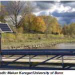
Measuring water levels with cm-level accuracy using GNSS-IR
Researchers at the Institute of Geodesy and Geoinformation at the University of Bonn, led by Dr. Makan Karegar, have transferred water -level monitoring technology from the Rhine to Africa, Australia, and the Philippines as part of ESA projects. Originally developed in the DFG Collaborative Research Center SFB 1502 …
Trimble Technology enables first centimeter-accurate 3D model
Trimble has announced its continued support of Project Pressure by providing advanced GNSS positioning technology and research funding for the nonprofit organization’s latest expedition to map the disappearing tropical glaciers of Puncak Jaya in Papua, Indonesia.
Project Pressure has released a centimeter-accurate, 3D model of the receding ice, …


 (5.00 out of 5)