
NOAA flood mapping now covers 60% of U.S.
NOAA’s National Weather Service (NWS) announced its experimental Flood Inundation Mapping (FIM) tool. The FIM provides near-real-time, high resolution, street-level visualizations of f lood waters to assist NWS forecasters in issuing flood watches and warnings. It helps provide …

Sixth GLONASS-K satellite lifts off
The liftoff of the Soyuz 2-1b/Fregat rocket with the sixth GLONASS-K satellite took place as scheduled on Sept. 13, 2025, from Site 43 in Plesetsk. Around five hours after the launch, the Ministry of Defense reported that both payloads had been delivered into …
RICS launches global AI standard for surveying
The Royal Institution of Chartered Surveyors (RICS) has published the first global professional standard for the responsible use of artificial intelligence (AI) in surveying practice.
Set to take effect on 9 March 2026, the new standard sets out mandatory …
UAVs assist forest officials
ideaForge Technology Limited deployed its Q6V2 UAV to support forest officials in preventing a potential human-elephant conflict in the Silli region of Jharkhand, India. The incident occurred when a herd of elephants strayed from the forest into nearby villages, creating panic among residents. Q6V2 UAV was launhced, …
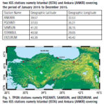
The study investigates ionospheric TEC variation over the Turkish region using 5 GNSS stations. The results showed that the overall TEC values display the trend of normal diurnal and annual TEC variations.
Kutubuddin Ansari
Faculty of Geodesy and Cartography, Warsaw University of Technology, Warsaw, Poland
Janusz Walo
Faculty of Geodesy and Cartography, Warsaw University of Technology, Warsaw, Poland
Selcuk Sagir
Department …

The analysis performed in this report is solely his work and own opinion. State Program: U.S.A (G); EU (E); China (C) “Only MEO- SECM satellites”; Russia (R); Japan (J); India (I)
Narayan Dhital
Actively involved to support international collaboration in GNSS related activities. He has regularly supported and contributed to different workshops of the International Committee on …

The Central and State governments have committed the policy of Jahan Jhuggi-Wahan Makaan, that is In-Situ Slum Resettlement in Delhi, replicating the Dharavi Model of Mumbai. While the policy is already mandated in the Delhi Master Plan, its implementation involves putting in place people centric, evolutionary and support-based tools that are more longitudinal and avoid …

Volume 21, Issue 8, August 2025
Educating primary school students about surveying
Volker Janssen
Solar radio bursts impact on the International GNSS Service Network during Solar Cycle
Manuel Flores-Soriano
GNSS Constellation
Specific Monthly Analysis Summary: July 2025
Narayan Dhital
My Coordinates
EDITORIAL
News
GNSS | IMAGING | UAV | INDUSTRY
CALENDAR
September 2025 – November 2025
Advertisers in this Issue :
SBG System
Tweet
September 2025
IAG Scientific Assembly 2025
1-5 September
Rimini, Italy
www.expouav.comhttps://eventi.unibo.it/iag2025
Commercial UAV Expo 2025
2-4, September
Las Vegas
www.expouav.com
Esri India User Conference 2025
September – Delhi 3rd & 4th, Kolkata 9th
Hyderabad 10th, Mumbai 12th
www.esri.in
ION GNSS+
08-12 …


 (5.00 out of 5)