Articles tagged with: MUNEENDRA KUMAR

“I always read that the world, land and water, was spherical… Now I observed so much divergence, that I began to hold different views about the world and I found it was not round…. but pear shaped, round except where it has a nipple, for there it is taller, or as one had a round ball and, on one side, it should be like a woman’s breast, and this nipple part is the highest and closest to Heaven….” – Kenneth C. Davis New York Times Best Seller “Don’t know much about Geography” Permissions Department, William Morrow and Company, New York, NY, 1992.

Of course, it would be extremely rare, when any GPS surveying and/ or “navigating” to the North Pole is undertaken. One such opportunity occurred In April 2005. British explorer Tom Avery in his effort(s) to recreate Adm. Robert Peary’s epic journey of April 1909 to North Pole took GPS to navigate himself…

To create no residual global rotation with regards to the crust in time evolution in orientation, IERS in the first ITRF88 retained the BIH Conventional Terrestrial System (CTS) and its Conventional Terrestrial Pole (CTP) 1984.0. Since then, it has realized the same “Pole”. However, IERS changed the name “CTP” to International Reference Pole (IRP).
Historical Start
The Earth’s first Terrestrial Reference Frame (TRF) was called Conventional International Origin (CIO) 1905 where the mean orientation of the Z-axis was defi ned by International Latitude Service from six years of observations between 1900 to 1905 (Note: There is NO other “CIO” ever defi ned). The records are not clear whether ILO ever provided a specifi c defi nition for the X-axis and/or the zero meridian.

In 1900, the International Latitude Service started to monitor the wobbling and wandering of the North Pole. Since that year, the North Pole has been moving south. In everyday terminology, it has moved secularly on the Earth’s surface in the only direction it knows, i.e., south. The total motion has been about 13.5 meter over the past 100+ years, which in other words amounts to an amazing rate of 13 cm per year or about 1 cm per month…

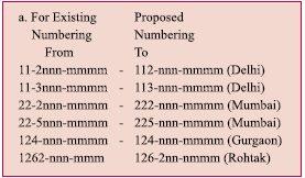
In India, the “extra” digits in telephone numbers have been added a number of times e.g., the digits for Delhi have changed from 5 to 8 in the past five decades. However, with the addition of extra digit of “2” (or “3” or “5”) in the phone numbers of the cities around the countries in December 2002, the total number has reached to “10”, i.e., “2, 3, or 4” digits of city codes plus “8, 7, or 6” digits of phone numbers. In one colony of Delhi, since…

The most important ingredient for “Preparedness”.Unless we are “fully” prepared, we cannot have good and timely
response. And, to be fully prepared with good coordinates is in the
hands of geodesists, surveyors, map or chart makers, and all others,
who generate data. In turn, correct and accurate “Good Coordinates”
and quick and timely advice will strengthen the hands of the country’s
leaders, civil and/or military.If anything is lacking in good
coordinates, “We” would be failing with no room for any excuse(s).

As the GPS surveying techniques started showing promise of high accuracy geodetic positioning in the early 1990s, few “open-minded” geodesists realized the possibility of using ellipsoidal heights in place of orthometric heights. Many conceptual approaches were mentioned and proposed in various applications. However, Steinberg and Papo were the fi rst to publish a paper entitled “Ellipsoidal Heights: The Future of Vertical Geodetic Control” (GPS World, Vol. 9, No. 2, 1998). As could be expected, Petr Vanicek, a geodesy professor, was quick to downplay the proposed new “type” of vertical control (GPS World, Vol. 9, No. 4, 1998). It seems that Steinberg and Papo did not “defend” their new proposal. Thus, in this paper, a review has been made to check and comment on Vanicek’s example against the ellipsoidal heights, reference to orthometric islands, and issuance of a warning for non-dissemination of ellipsoidal heights to Canadian users.


 (5.00 out of 5)