
Galileo – the European Programme for Global Navigation Services for civil purposes is an initiative led by European Union. We provide regular updates to our readers on the Galileo programme.
Abu Dhabi to introduce new road maintenance system
Abu Dhabi is preparing a unique Road and Bridge Asset Management System. The system would establish a satellite-aided geographical database by using the GPS. It will also feature an e-archives for road executive designs and an e-connection with other working systems. The system seeks to standardize the methods and costs of maintenance work of the 20, 000- km road network and 90 bridges in the emirates, according to an official at department for Municipalities and Agriculture. www.khaleejtimes.com
Geospatial Intelligence Standards: Enabling a Common Vision
The National Geospatial-Intelligence Agency (NGA) has issued a new document that provides guidance and direction to develop an overall baseline for common geospatial standards used to share, manipulate, and exploit digital geospatial data. The document, “Geospatial Intelligence Standards: Enabling a Common Vision,” outlines the standards that will be used in the National System for Geospatial-Intelligence (NSG). The NSG is the combination of technology, policies, capabilities, doctrine, activities, people, data and communities necessary to produce geospatial intelligence (GEOINT) in an integrated multi-intelligence, multidomain environment. www.nga.mil
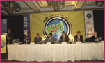
Second ESRI Asia-Pacific User Conference, 18-19 January, 2007, New Delhi, India
The Second ESRI Asia-Pacific User Conference under the theme of “GIS for economic development” was held at Hotel Taj Palace, New Delhi, India on January 18-19. Organized by ESRI India, the event witnessed participation from more than 900 …

Navigare Necesse Est is the Latin tag that underpins the basic necessity of all forms of life to fi nd their way to survive and prosper. Today’s new world of ubiquitous electronic navigation supremely illustrates that dictum. Says Dick Smith, newly elected President of the International Association of Institutes of Navigation (IAIN)
Would you …
Hemisphere GPS Innovation Wins FinOvation Award
Hemisphere GPS has announced that the Outback S2 GPS guidance system has won a FinOvation Award by Farm Industry News. The Award recognizes the most innovative new products published in Farm Industry News during the past year. The guidance system combines Crescent® GPS Technology with a simple guidance interface. When combined with Outback eDrive and the new BaseLineHD, it provides the most affordable one-inch pass-to-pass automated steering system available.
Hemisphere GPS has also introduced centimeter-level accuracy through a Real-Time Kinematic (RTK) application for professionals working in precision agriculture, marine navigation, surveying and others. It also provides the same accuracy as dual-frequency RTK systems but at a fraction of the cost. www.hemispheregps.com
April 2007
63rd Annual Meeting, Featuring New Bio Navigation Workshops
April 23-25, 2007, Cambridge, MA
www.ion.org
2nd National GIS Symposium in Saudi Arabia
23-25April, 2007 Al-Khobar, Saudi Arabia
info@saudigis.org
http://www.saudigis.org/
May 2007
TimeNav’07 – ENC-GNSS 07
29 May – 1 June 2007
Geneva International Conference Center,Switzerland
Spatial Sciences Institute Biennial International Conference
14-18 May, Hobart, Tasmania, Australia
www.ssc2007.com
Intergraph 2007
21-24 May, Nashville, Tennessee, …

Over the years topographic mapping generally involved acquisition of data related to the features of the earth, its environs of user’s interest and its graphic depiction on a suitable media, generally paper, ensuring that the accuracy specifications, which depend upon the type of end product, are strictly adhered to.
Over the years topographic mapping generally involved acquisition of data related to the features of the earth, its environs of user’s interest and its graphic depiction on a suitable media, generally paper, ensuring that the accuracy specifications, which depend upon the type of end product, are strictly adhered to.

Global Navigation Satellite System (GNSS) consists of GPS, GLONASS and Galileo which is still under construction by the European Union. GPS is the most widespread GNSS in the world and applies successfully in so many fields such as positioning, navigation, geodesy, mapping, timing and so on. However, GLONASS has not done its work well for about ten years because of lack of funds. In summer of 2006, Russia’s GLONASS program continued its comeback and will have a full 24-satellite constellation by the end of 2009. Notably, China has a regional RDSS system using three geostationary satellites since 2000.
INS is a self-contained positioning and attitude device. In other words, it meets the all-environment requirement. The primary advantage of using INS is that velocity and position of the vehicle can be provided with abundant dynamic information and excellent short term performance. The main shortcoming is that the INS accuracy degrades greatly over time.
Galileo – the European Programme for Global Navigation Services for civil purposes is an initiative led by European Union. We provide regular updates to our readers on the Galileo programme.


 (5.00 out of 5)