|
|
|
|
| |
 |
|
|
Products
Hemisphere GPS Innovation Wins FinOvation Award
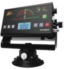
Hemisphere GPS has announced that the Outback S2 GPS guidance system has won a FinOvation Award by Farm Industry News. The Award recognizes the most innovative new products published in Farm Industry News during the past year. The guidance system combines Crescent® GPS Technology with a simple guidance interface. When combined with Outback eDrive and the new BaseLineHD, it provides the most affordable one-inch pass-to-pass automated steering system available.Hemisphere GPS has also introduced centimeter-level accuracy through a Real-Time Kinematic (RTK) application for professionals working in precision agriculture, marine navigation, surveying and others. It also provides the same accuracy as dual-frequency RTK systems but at a fraction of the cost. www.hemispheregps.com
|
|
|
Intermap to provide 3D data for Microsoft’s Virtual Earth
Intermap Technologies Corp. shall provide Microsoft with NEXTMap Britain digital elevation data for use within Microsoft’s Virtual Earth platform. The agreement enables to create and deliver a Live Search Maps product powered by digital terrain model of Great Britain.
www.intermap.com
|
|
|
|
Applanix introduces POSPac Air Software Version 4.4
Applanix has introduced POSPac AIR Version 4.4, the latest postprocessing software used to extend the accuracy potential of the POS AV system. It maximizes data quality and optimize workfl ow from project planning through to project completion.
www.applanix.com
|
|
|
Trimble introduces GNSS receiver for agriculture applications
Trimble has introduced a GNSS receiver for agricultural users-the AgGPS 442 GNSS receiver. It can track GLONASS and next-generation GPS L2C satellite signalsm which improves the farmers ability to work in tough GPS environments with faster initialization times, and provides for increased productivity and reduced downtime in the fi eld.
www.trimble.com
|
|
|
ArcGIS Server Code Challenge announced by ESRI
ESRI invites developers to share their creativity and expertise with the GIS developer community by submitting original code samples to the ArcGIS Server Code Challenge at www.esri. com/codechallenge. Developers will have an opportunity to review and vote for the top three entries based on creativity, applicability, and relevance of the code sample.
www.esri.com
|
|
|
smallTRIP: New Ntrip-client(GSM/ GPRS) with internal GPS receiver

The smallTRIP unit delivers correction data to GPS receivers through mobile Internet (GPRS) in the form of RTK or differential-GPS. Streams of correction data can be in many different formats (RTCM, CMR). It uses Ntrip protocol for communication with Ntrip casters or it can connect directly to a HTTP-stream from an Internet connected reference station. The unit is tested in Europe and the US on different Ntrip casters (GPSSpider, GPSnet and GNCASTER) and with many different GPS-receivers. Another feature of the unit is GSMmodem connection to a modem-based reference station.
www.smalltouch.com
|
|
|
Touchscreen chartplotters for international boaters
Garmin has announced the GPSMAP 5000 series of multifunction displays (MFDs) – super-bright touchscreen chartplotters having large waterproof (IPX7) superbright 12.1-inch diagonal XGA color display. It makes navigating menus a snap because the “virtual buttons” change depending on the function – allowing boaters to intuitively see and select the information they want, while eliminating the clutter they don’t.
www.garmin.com
|
|
|
BrightEarth-Global natural colour mosaic released
ComputaMaps releases BrightEarth, a natural colour image mosaic covering 95% of the Earth’s land surface at a resolution of 14.25m. The source is the orthorectifi ed Landsat 7 imagery acquired between 1999 and 2002 for NASA’s GeoCover programme. Using a proprietary algorithm, it has transformed the original false-color GeoCover imagery mosaics into a single color-balanced global mosaic with bright, vivid natural color that retains the high contrast detail of the original pan-sharpened source imagery.
www.computamaps.com
|
|
|
ProSDK and ProPacks 1.1 released by PCI Geomatics
PCI Geomatics release new version of the ProPacks collection and the PCI Professional Software Development Kit (ProSDK), used for building highly automated and customized workfl ow solutions. It is a set of software components that address a particular application area, such as orthorectifi cation or mosaicking, and extends the capabilities of the ProSDK called PCI Pluggable Functions (PPFs) representing PCI Geomatics’ core technology.
www.pcigeomatics.com
|
|
|
Sierra Atlantic signed as INPHO’s distributor for India
INPHO has appointed Sierra Atlantic Software Services Ltd, Hyderabad, for distributing INPHO’s digital photogrammetric software suite in India. www.inpho.de
|
|
|
NAVTEQ launches Map Reporter
NAVTEQ has updated its popular online feedback tool and renamed it NAVTEQ Map Reporter. The updated system is now map-based, giving users who discover potential discrepancies an easier way to provide feedback by pinpointing the exact location of the concern for possible updating of the database.
www.navteq.com
|
|
|
DVP-GS Version 6.2 released
DVP-GS has announced the release of Version 6.2 of its professional photogrammetry software. It offers new and improved functionality with increased productivity and a completely revamped Orthomosaic module. www.dvp-gs.com
|
|
|
NID and Autodesk to promote design education
The National Institute of Design (NID), India and Autodesk has signed an agreement helping student to develop CAD skills. Richard Jones, Vice President of Autodesk said that under the agreement students on all three campuses – Ahmedabad, Bangalore and Gandhinagar – will be equipped with the latest versions of Autodesk’s design software such as Autodesk Inventor, AutoCAD Mechanical, AutoCAD electrical and ALIAS design tools.
www.gujaratglobal.com
|
|
|
MapInfo Acquires Graphical Data Capture
MapInfo Corporation has acquired Graphical Data Capture, Ltd., (GDC), a London-based location intelligence provider and partner of MapInfo for the past 17 years. GDC develops applications and offers consulting services primarily to local and regional UK government authorities, in addition to utilities, financial services and insurance companies.

|
|
|
Leica Cyclone 5.6 new Capabilities to Laser Scanning
Leica Geosystems announces the release of Leica Cyclone 5.6 software. The new SurveyingT software version lets users take advantage of laser scanners for popular orthophoto and stakeout workflows for surveying and mapping. The software enables users to efficiently control Leica HDS scanners and process rich point cloud.
|
|
|
NovAtel Inc. Launches Latest GPS/GNSS Engine
NovAtel launches DL-V3 – a rugged, feature-rich enclosure housing NovAtel’s GPS/GNSS OEMV- 3 engine. It has features such as Bluetooth for wireless connectivity and Ethernet for remote network access, as well as a removable Compact Flash card for data security and portability. It is also capable of tracking both GPS and GLONASS, and future GPS L5, signals. It delivers sub-meter positioning using OmniSTAR® or Canada-wide Differential Global Positioning System (CDGPS) LBand correction services. Real-time Kinematic (RTK) solutions, including NovAtel’s latest AdVanceT technology
|
|
|
Trimble Acquires INPHO GmbH
Trimble has acquired INPHO GmbH in an all-cash transaction. INPHO has a large customer base of more than 1,000 users in over 100 countries.Its products are used by service companies offering geospatial data collection by photogrammetry and Lidar as well as state authorities involved in supplying geospatial information.
|
|
|
TopoSys North America Inc. founded
TopoSys GmbH, Germany, has founded it North American subsidiary in Denver, Colorado, which would serves as a sales and support center for TopoSys Lidar systems in North America.
www.toposys.com
|
|


 (No Ratings Yet)


