
ISRO to develop Indian satellite security cover
ISRO will develop its own version of the US GPS and Russian Glonass system, albeit with a limited, regional capability, with the added advantage of providing the country’s defence establishment round-the-clock security cover. The constellation of seven satellites will keep an eye on a wide swath of territory – 2,000km – in and around the Indian sub-continent. According to ISRO chief, G Madhavan Nair, the Indian Regional Navigational Satellite System (IRNSS) was being developed “considering security related issues”. www.domain-b.com
Survey of India maps for SatNav
SatNav Technologies and Survey of India (SOI) have signed an agreement that allows SatNav to use SOI maps in its consumer products. It will release SOIapproved digital maps and custom map content for commercial use in personal and mobile navigation and locationbased solutions. www.satguide.in

The high pile wharf has the advantage of slight wave reflection, steady anchoring condition, little investment and the construction time being short. Therefore it has been widely used in coastal areas where the ground has soft soil. But, on the other hand its penetrant structure raises some problems also for the structure. In order to guarantee the request of ships draft, the front water area of the wharf has to be dug more deep,…

The term Terrestrial 3D Laser Scanning scan is commonly referred to the process of collecting large number of data points through high performance hardware devices (3D Laser Scanners) delivering raw data outputs in the form of point clouds or cloud of points (CoP). The concept of High-Definition surveying, on the other hand, extends the capabilities of 3D Laser Scanners by providing effective field and office workflow solutions in combination…
“We are convinced that if we are to play a meaningful role nationally, and in the community of nations, we must be second to none in the application of advanced technologies to the real problems of man and society.”…

In the rapidly changing economic, technological, political, and social environment that characterises the world as we see it in the 21st Century, every profession faces major challenges, surveying being no exception. While some of these challenges are common across all professions, others are specific to the surveying community. In this discussion I choose to separate the challenges facing the surveying profession into these two categories…
September 2009
Benetley Be connected Online Seminars
September to November
http://bentley.com/BeConnected
October 2009
European Navigation Event 2009
6 October
Houten, The netherlands
http://www.navigationevent.com
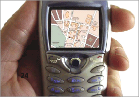
LBS appear to be one of the next natural steps in our move towards a truly unwired permanently connected society
The past decade has seen a quantum jump in mobile usage driven by two factors – one on the basic premise that almost everyone talks and walks and secondly, the underlying technology that has enabled this …

Indian Institute of Surveying and Mapping (IISM) is the country’s premier institution for human resources development in the realm of surveying and mapping in its modern incarnation. IISM recognizes that the cutting edge in the process of development is information dissemination. Hence, its efforts of generating awareness among various organization and training its manpower in modern trends in Surveying & Mapping like GPS, Total Station,…
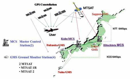
The Multi-functional Satellite Augmentation System (MSAS) is a Japanese Satellite Based Augmentation System (SBAS) [1] which provides Differential GPS (DGPS) corrections and is designed to supplement GPS by reporting and monitoring the reliability and accuracy of GPS signals in real time. MSAS consists of two satellites, (MTSAT-1R at 140E longitude and MTSAT-2 at 145E longitude), four Ground Monitor Stations (GMS), two Master Control Stations (MCS),…


 (5.00 out of 5)