

The 20th INTERGEO will be a mix of technical sessions; a conference and trade show and a variety of side events, giving you a unique opportunity to discuss best practices within the geo-branch. Do not miss this great event: INTERGEO will take place from 7 to 9 October 2014 in international metropolis Berlin.
INTERGEO interview with …

NovAtel Inc. has added the IMUKVH1750 as an inertial measurement unit (IMU) option in its SPAN GNSS/ INS line of positioning products…
Russia’s Deputy Prime Minister Dmitry Rogozin has described as politically motivated the USs’ decision to freeze the construction of GLONASS signal calibration stations…
The Kerala Water Authority (KWA) is vetting a proposal to prepare 3D GISaided maps of pipelines in the city’s distribution system. The maps would help the KWA…
The Canadian Space Agency (CSA) has awarded a $1.35-million contract to Ontario’s Neptec Design Group for work on Canada’s contribution to the Japan…
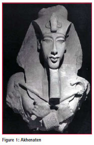
During his relatively short reign of 17 years the highly controversial pharaoh of ancient Egypt derogatorily described as “The Heretic King” caused the most disruptive religious upheaval of the entire period of the legendary civilisation. Akhenaten took the throne of New Kingdom…

After years of development, as the representative of GNSS, GPS technology has been gradually replacing the conventional triangulation techniques and has become the main means of access to ground control point coordinates. From the initial decimeter magnitude to the current sub-centimeter or even millimeter level, the coordinate precision of ground points has been highly improved upon…


 (5.00 out of 5)