| Surveying -New | |
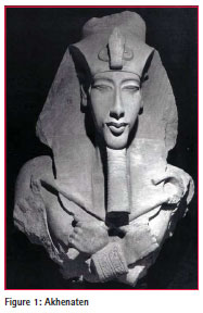
The boundary stones of Tutankhamun’s father – Akhenaten’s city of the sun
The paper describes the design and layout of these impressive ancient surveyor’s boundary stones along with contemporary history leading up to the most recent events affecting Akhenaten’s Stelae as a spectacular example of the vital importance of surveyors during this turbulent period of the Great Egyptian Civilisation |
|
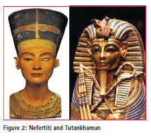
During his relatively short reign of 17 years the highly controversial pharaoh of ancient Egypt derogatorily described as “The Heretic King” caused the most disruptive religious upheaval of the entire period of the legendary civilisation. Akhenaten took the throne of New Kingdom Egypt under his birth name of Amenhotep IV after the death of his father Amenhotep III in 1353 BC. After a few years in charge he changed his name to Akhenaten and his brief time on the throne even brought about a stylistic variation to the artistic depictions of Egyptian art. Even though his rule was so noteworthy it is one of his wives, Nefertiti, and his son, Tutankhaten (who changed his name to the more traditional Tutankhamun after his father’s somewhat mysterious death?) who are the most renowned individuals of the ancient civilisation. Tutankhamun’s golden death mask and the splendid coloured marble bust of his stepmother, Nefertiti, would be the most identifiable artefacts out of any recovered from the historic era of affluence during which they were crafted.
Not only did this determined despot try to replace the established principal God, Amun together with his pantheon of subsidiary gods, with a single deity called the Aten (simply identified as the Sun Disk) he even relocated the capital of the nation at a place which he purported was chosen by his Aten at a site previously unoccupied by humans as far back as Egyptian history could identify. The chosen area for his new capital called Akhetaten (of course!) was in central Egypt between high cliffs to the west and lower highlands along its eastern edge with the life-giving River Nile flowing through the city.
This eccentric Egyptian ruler may have been despised by the temple bureaucracy who resented his dictatorial decree to install a new monotheistic religion over the thousands of years of their established system, he must have been equally revered by his Scribes of the Fields – partly represented by the Cadastral Scribe Surveyors. As a demonstrative sign of the spiritually chosen city site Akhenaten engaged his boundary creators to place most substantial boundary stelae around the perimeter of his new city along its western and eastern sides. The distinctive boundary markers consisted of images of the Pharaoh and his family in adoration of the Aten with the sun’s rays bathing the group along with extensive hieroglyphic recitals declaring how the site was selected and the distances from each stone carving to the next. His obsession with everything “Aten”, even to the extreme of naming ALL of his children with that nomen as a suffix, Merytaten, Meketaten and Tutankhaten can be identifiable with his equally obsessive preoccupation with his new city. Through his insistence on the placement of such impressive boundary monuments and the declaration of the distances from one stela to those adjoining it signifies the essential importance cast upon those Cadastral Scribe Surveyors entrusted with the duty of bringing this perimeter demarcation into reality. Through his own proclamations the boundaries of his capital, literally meaning “Horizon of the Aten”, were established for eternity and divinely protected by the God and his reincarnation on earth, Akhenaten himself.
During the 1980’s an exhaustive reanalysis of each of the surviving boundary stelae was carried out by a team mainly funded by the Committee on Research of the American Philosophical Society under the leadership of William J. Murnane and Charles C. Van Siclen III such field exercise being titled “The El Amarna Boundary Stelae Project.” A very excellent text based on the findings of this project was published which is a most authoritative and thorough treatise on these monuments to the might of the Cadastral Scribe Surveyors of Akhenaten.
Introduction
Akhenaten’s obsession with his instatement of The Aten as the sole Egyptian deity was ultimately rejected and refuted by the majority of the populace led stoically by the religious bureaucracy who resented the dislocation of thousands of years of established theocracy. The new Pharaoh even relocated the capital of his dominion to a desolate area of middle Egypt previously uninhabited said to have been bestowed upon him by his new God. Along with the substantial capital construction necessary for the presentation of the required status to portray the image of the nation’s main city Akhenaten also demonstrated the major significance he placed upon the accurate location and prominence of the monumentation to delineate the boundaries of his new metropolis.
Clearly the Cadastral Scribe Surveyors were among the VIPs in the heretic pharaoh’s divine workforce being responsible for the marking out of the city limits for the new capital with most distinctive stelae carved with the Royal decrees of their omnipotent leader. Placed at strategic positions around the perimeter of the city territory these superb examples of city boundary demarcation have lasted for in excess of 3300 years since their installation, but in more recent times the greed of the ancient artifacts dealers have brought about the destruction of the formerly best preserved example of these stone boundary markers. Hapless thieves tried to steal the Stela S at the south eastern border area by blowing the stone face from the cliff wall with explosives but all they succeeded in achieving was the complete disintegration of the precious link with the revered ancient civilisation.It is hoped that these dunderheads have learnt a lesson from this feeble-minded effort so that there are no further attempts to desecrate the remainder of these priceless ancient landmarks.
The following paper will describe the design and layout of these impressive ancient surveyor’s boundary stones along with contemporary history leading up to the most recent events affecting Akhenaten’s Stelae as a spectacular example of the vital importance of surveyors during this turbulent period of the Great Egyptian Civilisation.
Akhenaten’s accession to power
When Amenhotep III died his son Amenhotep IV ascended to the throne ultimately bringing with him the seeds of unprecedented revolution which would emanate from the throne of the King Himself. The year was 1353 BC and the great empire was already confronting serious challenges to her borders from aspiring tribes led by warrior leaders.
At first there was little suggestion of the major upsets to be thrust upon the unexpecting population and stunned temple bureaucracy but the consequences would be major.
Shortly after assuming his divine position the new pharaoh changed his name to Akhenaten and had instated the representation of the solar disc, The Aten, as the sole god to be worshipped by his resistant minions. His next major disruption to the establishment was to start construction of a new capital city at a previously uninhabited area of central Egypt straddling the Nile in the area now known as El Amarna. His first component in the creation of his new Egyptian Administration Centre was to have his Scribe Surveyors place imposing boundary stelae at the significant points around the perimeter of his new domain to display his control over his metropolis along with the Regal decree to demonstrate the divine selection of this site.
Akhenaten was a very family orientated ruler and he often has himself depicted upon his carved stone imagery nursing or touching his children together with his wives represented at the same level of proportion as himself such presentation being a departure from prevailing standards of art.
His most favoured wife was the beautiful Queen Nefertiti famously immortalised in the superb coloured marble bust held in the Cairo Museum while the most recognised image and character of all from the ancient race is of course Tutankhamun whose treasures focused unequalled interest in ancient Egypt when Howard Carter found his undisturbed tomb cache in 1922. Tut’s mother was another wife named Tiy and his birth name was Tutankhaten which he had changed to the more well known version quite quickly after his father’s mysterious death to reconcile his patriarch’s damage to the morale of his nation.
Modern discovery of the Stelae
The first modern traveller to make note of Stela A was the Jesuit priest Claude Sicard in 1714 and it was only mentioned once again in the eighteenth century in 1777. Next Joseph Bonomi viewed it in 1825 with Robert Hay making sketches of the site in 1827 having possibly been informed of it by John Gardner Wilkinson. The largest of the boundary monuments, Stela U, was discovered by A.C. Harris and George Gliddon in 1840. Various other tourists noted and made drawings of some of the stelae being Nestor L’Hote, George Lloyd, E. Prisse d’Avennes and Karl Richard Lepsius during the 1840’s.
However the most significant and thorough discovery and recording of the majority of the stelae was made by The Father of Egyptology, William Matthew Flinders Petrie, in 1892. You may notice the middle names of this prolific figure of modern Egyptology because he is the grandson of the legendary marine surveyor of Australia Matthew Flinders and with such an illustrious pedigree in scientific discovery it is not surprising that Petrie revolutionised the recording of ancient sites through the introduction of accurate surveying techniques for the chronicling of all discoveries.
In more recent times a more intensive investigation of these phenomenal in-situ boundary stones was undertaken under the leadership of William J. Murnane and Charles C. Van Siclen III in the early 1980’s. The El Amarna Boundary Stelae Project was funded by the Committee on Research of the American Philosophical Society, the Oriental Institute and the American Research Center in Egypt and produced a brilliant book titled “The Boundary Stelae of Akhenaten” first published in 1993 by Kegan Paul International Ltd., London.
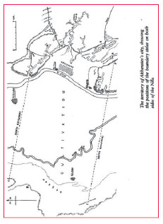
Two types of boundary stelae have been identified by the scholars who have analysed the great monuments. The different styles are known as The Earlier Proclamation and the Later Proclamation with the first placements being made in the King’s Regnal Year 5. The remaining extant stelae are numbered with letters starting with Stela A in an anticlockwise direction up to F on the western side across the southern boundary to Stela P then northerly to Stela X at the north eastern corner to define the northern boundary back across to the starting Stela A. Stelae K, M and X are the only monuments which bear this initial decree also showing his first daughter Meritaten only while the remaining carvings were made in Akhenaten’s sixth Regnal year and later. The stones containing the Later Proclamation are of somewhat more interest to surveyors as they define the dimensions of the city’s limits, measuring from the stelae on the east bank to those on the western borderline. Southern stelae bear a codicil dating to early in Akhenaten’s eighth year which records a royal visit to these sites. After a relative period of inactivity there seems to have been a rejuvenation of effort by the capital works team subsequent to these Royal visitations with the King’s two later daughters being added to the imagery and text sculpted onto the monuments during his eighth year.
A most tragic incident took place in early 2004 when antiquities thieves completed destroyed Stela S with explosives leaving just a gaping hole in the rock where the great monument had proudly stood for over 3,300 years. The only fortunate feature of this recent vandalism is that at least we have thorough and comprehensive recordings of this remarkable symbol of the outstanding society which set it in stone all of those many years ago for the rest of posterity of which artifacts robbers are not inclusive.
Apart from the King’s declaration as to the divine choice for his new capital he also adds the following decree to the titulary on the south eastern stela:
“As for the southern stela which is on the eastern mountain of ‘Horizon of the Orb’, it is the stela of ‘Horizon of the Orb’, the one beside which I make my stand. I shall not go past it to the south forever and ever. Make the south-western stela across from it on the western mountain of ‘Horizon of the Orb’ exactly!
“As for the intermediate stela on the eastern mountain of ‘Horizon of the Orb’, it is the stela of ‘Horizon of the Orb’, the one beside which I make my stand on the mountain of the orient- (side) of ‘Horizon of the Orb’. I shall not go past it to the orient forever and ever. Make the intermediate stela which is on the western (side) of ‘Horizon of the Orb’ across from it on the western mountain of ‘Horizon of the Orb’ exactly! I shall not go past it to the west forever and ever.
“As for the north-eastern stela of ‘Horizon of the Orb’ by which I make my stand, it is the northern stela of ‘Horizon of the Orb’. I shall not go past it downstream forever and ever. Make the north-western stela which is on the western mountain of ‘Horizon of the Orb’across from it exactly!”
The great Pharaoh even goes further with his attention to survey detail by adding dimensions to his Holy City: “Now, as for ’Horizon of the Orb’, starting from the southern stela of ‘Horizon of the Orb’ as far as the northern stela, measured between stela to stela on the eastern (var. western) mountain of ‘Horizon of the Orb’, it makes six iter, one and threequarter rods and four cubits.
“Similarly, starting from the southwestern stela of ‘Horizon of the Orb’to the north- western stela upon the western mountain of ‘Horizon of the Orb’, it makes six iter, one and three-quarter rods and four cubits similarly, exactly!”
Conclusion
In the modern metric system these stated ancient Egyptian dimensions are said to be equivalent to 20,000 cubits (10.5 kms) for the iter or itrw, one rod (or sacred rod of chord) is 100 cubits (52.5 metres) and one cubit is 0.525 metre. Thus the stated separation distances between the stelae is 63 kilometres and 93.975 metres north to south with an east-west line at 192 kms from Stela A to Stela X as well as 200 kms in the south of 200 kms from Stela F to Stela J which would make the area of the capital city about 12,500 square kilometres plus (about 7800 sq. miles plus) This area figure is subject to much more refinement due to the irregularities of the stela positions along the western and eastern boundaries of the city. However such substantial distances to be verified by the Cadastral Scribe Surveyors (Scribes of the Field) would have been a major undertaking with the knotted ropes available to these most skilled ancient surveyors but extant structures like the Pyramids and temples are positive indicators set in stone of the capabilities of their accurate measurement skills.
References
1. BROCK, John F., Four Surveyors of the Gods: In The XVIII Dynasty of Egypt – New Kingdom c. 1400 B.C., Proceedings of FIG Working Week (Cairo, Egypt, Saturday April 16, 2005)
2. BROCK, John F., Pyramids to Pythagoras: Surveying From Egypt to Greece – 3000 B.C. to 100 A.D., Proceedings of FIG Working Week (Athens, Greece, Monday May 24, 2004)
3. BROCK, John F., Surveying For The Pharaohs – The Scribes of Ancient Egypt, Proceedings of The Greatest Show in History: From Moses to MGM – A Surveying Odyssey (Sydney, Monday May 19, 1997)
4. MURNANE, William J. and VAN SICLEN III, Charles C., The Boundary Stelae of Akhenaten, (Kegan Paul International Ltd. 1993, London)
5. MURNANE, William J., “The El Amarna Boundary Stelae Project”, oi.uchicago.edu


 (58 votes, average: 1.02 out of 5)


Leave your response!