
The move on 26 May will see the Airservices Navigation Rationalisation Project switchoff 179 navigation aids, including nondirectional beacons, VHF omni-directional…
Earth-i UK has signed a MoU with space technology and enabled services specialist, Telespazio VEGA. This MoU will permit each company to provide each other’s specialist products…
The new to be released GIS server from Supergeo, SuperGIS Server 3.3, is a product designed to meet the modern technologies in client side applications…
Icaros Inc. has announced that Harris Geospatial Solutions will offer the Icaros OneButton™ family of image processing software as a front-end complement to its…
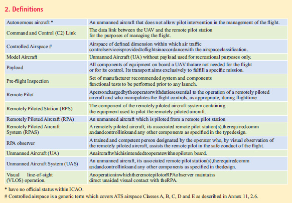
The UAS consists of an Unmanned Aircraft (UA), a Remote Pilot Station (RPS), Command and Control (C2) Link, the maintenance system and the operating personnel…

GPS positioning system is designed to determine the position of a point any time and at any place with an accuracy that could reach a few millimeters depending…

This is with reference to the draft “The Geospatial Information Regulation Bill, 2016”, posted on…

With exhibitors and visitors having high expectations of INTERGEO as an international business platform, Jens Lichte says the organisers are going all-out to position this year’s event in Hamburg as a truly global gathering
Hinte GmbH and DVW – the German Society for Geodesy, Geoinformation and Land Management – have set the stage for future development …


 (5.00 out of 5)