
Urban Population in India increased from 62 million (19%) in 1951 to 377 million (31%) in 2011, and is expected to increase up to around 37% by 2021.
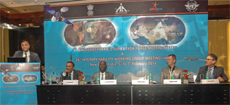
After the recent landmark achievement of certification of Indian SBAS System GAGAN for RNP 0.1 operations, India is hosting two back to back high-level technical meetings i.e. 4th Ionospheric Study Task Force (ISTF/4) under the aegis of ICAO and the 26th Interoperability Working group in New Delhi , providing further impetus to harmonized development of Satellite Based Navigation systems across the world.
Applanix Corp and American Aerospace Advisors Inc have completed a successful series of test flights of AAAI’s RS-16 platform equipped with Applanix’ DMSUAV
30th December 2013 is an important milestone in the history of Indian civil aviation as initial certification of GAGAN (GPS Aided GEO Augmented Navigation) has been issued by DGCA and India joins the elite club of countries along with USA, Japan and Europe to implement the operational SBAS

Spatio-temporal rainfall changes at tropics had raised concern among scientists. However, comprehensive studies at catchment scale of Southeast Asia where the combined regional and local factor is a tough task to be carried out due to the inherent limitations of rainfall data sources especially in the remote

Continuously Operating Reference Stations (CORS) networks have been utilized for the last two decades in most developed and some developing countries by surveyors, geomatics and earth scientists and engineers. They handle Global Navigation Satellite System (GNSS) data which support three dimensional positioning not only
The European Space Agency launched its star-surveying satellite Gaia into space, hoping to produce the most accurate 3-D map of the Milky Way and to better understand the evolution of our galaxy.

The U.S. Department of Transportation’s Federal Aviation Administration (FAA) released on November 7, 2013 its first annual Roadmap outlining efforts needed to safely integrate unmanned aircraft systems (UAS) into the nation’s airspace. The Roadmap addresses current and future policies

Bhuvan (www.bhuvan.nrsc.gov.in), a unique geoportal of NRSC that provide diversified geospatial services, is gaining popularity day by day and is much appreciated for its dynamic services. Initiated in 2009, Bhuvan has grown up rapidly and has made its impact on Indian user community. Expanding it’s state-ofart facilities and a datacentre at Hyderabad, Bhuvan is now extending geographically with its distributed architecture.
The Eighth Meeting of the International Committee on Global Navigation Satellite Systems (ICG) was held in Dubai, United Arab Emirates (UAE) from 10 to 14 November 2013 to continue reviewing and discussing developments in global navigation satellite systems (GNSS) and to allow ICG members, associate members, and observers to address recent developments in their organizations and associations with regard to GNSS services and applications.


 (5.00 out of 5)