| Imaging, News Archives | |
IMAGING
|
||||||||||
Russia to Launch South Korean Satellite in August
A Russian rocket will launch South Korea’s latest multipurpose Arirang-5 satellite on August 22, Seoul’s science ministry said. A backup launch date has also been set for August 23. The Arirang-5 is South Korea’s first satellite with a synthetic aperture radar, which enables observation of the Earth’s surface and also helps monitor natural disasters and the environment. RIA Novosti
China’s satellite data network reaches South China Sea
A satellite data receiving station was launched enabling China to now obtain observation information about the South China Sea.The station, in Sanya in south China’s island province of Hainan, was launched by the Institute of Remote Sensing and Digital Earth under the Chinese Academy of Sciences.
China will now be able to obtain satellite remote sensing data of the country’s southern territorial waters for civil use directly from its ground-based receiving facilities, according to an institute statement. http://news.xinhuanet.com/
ISRO’s geoportal Bhuvan turns 3-dimensional
ISRO’s geoportal Bhuvan, that helps in geo-mapping and navigation across India, has turned 3-dimensional. This is an attempt to bring the portal at par with Google Earth, say scientists.
“The new 3D feature of the portal is ISRO’s attempt to bring Bhuvan at par with Google Earth. The geoportal also includes Pocket Bhuvan. It is accessible on all smartphones and functions like Google Navigation,” said Himanshu Pandya, a scientist at the Space Application Centre (SAC), an important city-based arm of ISRO that provides regular updates to the portal regarding natural disasters and water bodies.
The 3-D features will enhance the experience of portal users. Bhuvan, launched in 2009 to mark the 90th birth anniversary of Vikram Sarabhai, is maintained by the SAC and Hyderabadbased National Remote Sensing Centre. www.indianexpress.com/
Ecuador satellite hits Soviet-era space junk
A tiny Ecuadoran satellite that collided in space with the remains of a Soviet rocket survived the crash, but was damaged and is not transmitting, Ecuador’s space agency EXA had warned that a space fender-bender was likely between its “Pegaso” (Pegasus) nanosatellite and the remains of an S14 rocket launched by the Soviet Union into space in 1985, in the midst of the Cold War. http://www.spacewar.com/reports/
GMES and data, like geese and golden eggs
A recent study brings forward the idea that data from the upcoming Sentinel series of satellites should be regarded as Public Sector Information, increasing their value for money. Through the Global Monitoring for Environment and Security (GMES) programme, decision-makers will have access to reliable, timely and accurate information services to manage the environment, understand and mitigate the effects of climate change and ensure civil security.
The programme will rely heavily on data provided by the Sentinel family of satellites – the first of which is due for launch later this year.
The potential of these data and information to be ‘reused’ both for commercial and non-commercial purposes recently came into focus in an ESA-commissioned study. In the final report, the authors outlined how reusing the data could potentially generate new businesses and jobs, and provide consumers with more choice and more value for money.
The report notes: “GMES may well be Europe’s goose capable of laying golden eggs. But how can we ensure a steady sustainable business model: do we take one egg (direct returns from sales of data) or do we allow the egg to hatch, hoping more golden-egg-laying geese will follow?” http://www.esa.int/
Nigeria: FG to Curb Insurgence with Satellite Imageries
President of Nigeria has declared that the country was prepared to curb insurgency in the country with the use of high resolution imageries to locate any suspicious changes on the landscape. He further said high imageries like Geo-Eye, Quick Bird, Ikonos or digital globe would be deployed to tackle the challenge of insecurity. http://allafrica.com/
First authorized UAV flight in a urban environment in Italy !
ANTEOS RPA of the Italian AERMATICA is the only one UAV that obtained the permission to fly in not segregated airspace from the Italian Civil Aviation Authority (ENAC).
AERMATICA and GEOMATICA_LAB from the University of L’Aquila – led by its Chief Scientist Prof. Donatella Dominici – agreed a collaboration regarding photogrammetric surveys. The first survey has been of one of the most important churches damaged during last earthquake: the Basilica di S.M. di Collemaggio (Unesco Heritage).
The aim of this study is to create a three dimensional models of both the building and its roofs using photogrammetric dedicated techniques. http://www.suasnews.com/
Bihar, India launches aerial survey of revenue land
Bihar government in India has launched an aerial survey of revenue land in the state. The survey, estimated to cost Rs 579 crore, would be completed by 2015 and thereafter, the state would have updated, computerized record of land holdings. Three private agencies have been engaged for the project. http:// articles.timesofindia.indiatimes.com/
Astrium delivers first VNREDSat-1 images just 48 hours after launch
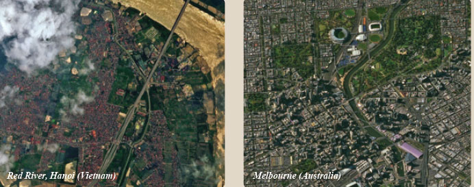
The pictures show Hanoi’s Red River (Vietnam) and the city of Melbourne
(Australia) at a resolution of 2.5 metres. www.astrium.eads.net/en/
3D-enabled spatial data model for the Kingdom of Bahrain
The Kingdom of Bahrain has taken a step closer to developing a new 3D enabled spatial data model of the nation following a new partnership between Ordnance Survey International and the Survey and Land Registration Bureau (SLRB). The SLRB is the government organisation responsible for land, aerial and hydrographic survey services and the registration of real estate properties in the Kingdom of Bahrain. As part of the recently signed agreement, the SLRB will call upon the expertise of Ordnance Survey International to design and build a new 3D-enabled national spatial data model. www.ordnancesurvey.co.uk


 (No Ratings Yet)


Leave your response!