Articles in the Positioning Category

GNSS positioning/navigation devices are rapidly merging into and changing our modern lives, just like the personal computer in the 1980’s and the cellular phone in the 1990’s. It is predicted that by 2012, the annual shipment of navigation devices will increase to over 65 million units, which is more than three times the 19.8 million shipped in 2006 [1]. Also in a situation personal computer and cellular phone ever faced, a higher standard service…
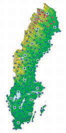
SWEPOS™ is a network of GPS/GLONASS reference stations which began as a co-operation between the National Land Survey of Sweden and Onsala Space Observatory. The early design phases of SWEPOS were made in 1992. It was already then stated that the network should be of both scientific and practical benefit to the professional GNSS users and the public. The purposes of SWEPOS are mainly to [1]…

The system presented in the paper is designed according to the scheme of compensation and processes navigation data with use of a Complementary Extended Kalman Filter (CEKF). The INS/TACAN/ALT system works with a feed-forward correction, i.e. there is no feedback to INS and its errors are corrected externally. The structure of system is shown in the Fig. 1…
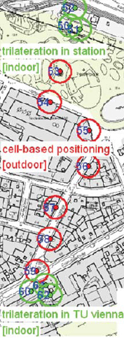
Alternative location methods for absolute positioning in areas where no GNSS position determination is possible due to obstruction of the satellite signals are needed in mobile positioning. Active RFID (Radio Frequency Identification) can be used also for position determination, although the system was not only developed for positioning and tracking but mainly for identification of objects. Using RFID in positioning, different approaches can be distinguished, i.e., cell-based positioning if the RFID tags are installed at active landmarks (i.e., known locations) in the surroundings, trilateration if ranges to the RFID tags are deducted from received signal strength (RSS in RFID terms) values and location fingerprinting where the measured signal power levels are used directly to obtain a position fix. Using Cell of Origin (CoO) the achievable positioning accuracy depends on the size of the cell and is therefore usually several metres up to 10’s of metres using long range RFID equipment. Higher positioning accuracies can be obtained using trilateration and fingerprinting. In this paper the use of trilateration is investigated.

The ionosphere represents one of the most important error sources that affecting GPS positioning. It is strongly related to solar activity and geomagnetic ?eld. The GPS satellites and dual frequency receivers can be used to measure the Total Electron Content (TEC) of the Earth’s ionosphere. Global electron content maps have been produced by various research centers using the world-wide permanent network of GPS receivers. In this study a rapid method of monitoring the ionospheric disturbance using dual frequency GPS data of the Aristotle University Thessaloniki (AUT1) permanent station is presented. The Total Electron Content can be determined using the so called Single Layer Model (SLM) of the ionosphere. The SLM is based on the assumption that all free electrons are concentrated in a spherical layer of in?nitesimal thickness (single layer) at height H above the earth’s surface. The Total Electron Content is modeled as a truncated Taylor series with the geographical latitude and the hour angle of the sun as independent variables, using the L4 – geometry free linear combination. The results are con?rmed using global information for Sun spot and geomagnetic activity from NOAA and Kyoto University respectively.

In the last several years we have seen an explosion of consumer GPS products. Telematics systems, LBS applications on cell phones, GPS-enabled PDAs, and more novel GPS products such as pet finders have flooded the marketplace, with new products and applications announced almost daily. Likewise, public awareness of the potential utility of GPS has increased. Microsoft’s and Google’s entrance into the GPS and mapping market have helped accelerate consumer understanding and adoption of location technology. This is also causing a major demand among users of LBS technology to “show what is around me.” In a word, GPS is a general term in the marketplace to which consumers are accustomed in how they understand and explain all location-enabled products and applications. What’s interesting is that GPS is not even the positioning-enabling (or location-enabling) technology inside many of these new locationaware applications that are getting a lot of traction these days. Moreover, Google and the other online mapping consumer websites are a disruptive technology for GPS because they don’t require the use of GPS – users can either self provision by entering a street intersection or applications like Google Local and Microsoft Local Live use WiFi for location sensing to the nearest access point.
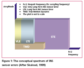
According to Skaloud [1999], the inertial sensor errors are composed of long term errors (low frequency components) and short term errors (high frequency components). Therefore, a conceptual plot of the frequency spectrum of the inertial sensor errors in the measurements can be illustrated as in Figure (1).
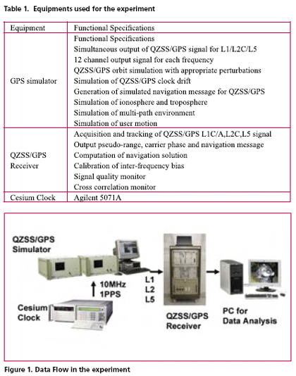
GPS modernization will expand the area of positioning service and will increase its convenience. Particularly, the third civil frequency namely L5, which will be provided by both modernized GPS and QZSS, is expected to improve the performance of precise positioning using carrier phase observation. This paper reports an experimental result regarding the convenience of additional L5 signal. Actual navigation signals generated from GPS simulator were received by triple frequency GPS receiver in the experiment. Navigation data, pseudo-range and carrier phase observation have been obtained and used for the analysis. This experiment verifies the improvement of ambiguity fixing time and multi-path mitigation using three frequency signals.
In the present paper, a method making a long baseline kinematic positioning possible in the present dual frequency system is discussed
In the discussion, the wide lane observation equations are used, since the initial ambiguities of wide lane combinations are calculated easily by using HMW (Hatch- Melbourne-Wübbena) combinations.
The three prime entities that are involved in the maintenance of Land information system (LIS) are the Department of Revenue, Department of Survey, Settlement and Land Records, and Offi ce of land registration. In addition to this, the appropriate municipal or village administrative unit is also involved. This is the convention in many states in India. The land records in India, do not provide ultimate title to property. In other words we need a system of effi cient maintenance of land records which is essential for protection of land rights of several millions of people in the country. Land has been one of the most sought after possessions in developing countries such as ours, wherein, the land holding has socio economic significance and status. Thus there is a need to develop an integrated LIS. A lot can be said and discussed about various activities and issues that are being dealt to create a LIS in different parts of the country. There are some success stories in Karnataka and some efforts of Governments in the states of Andhra Pradesh, Gujarat and Madhya Pradesh.


 (5.00 out of 5)