Articles in the Articles Category

The primary objective of ISAC is to build satellites to meet national requirement of the country in various application areas like satellite-based communication, navigation, national natural resources management, oceanography, meteorology, cartography and exploration of outer space and other planets, etc.
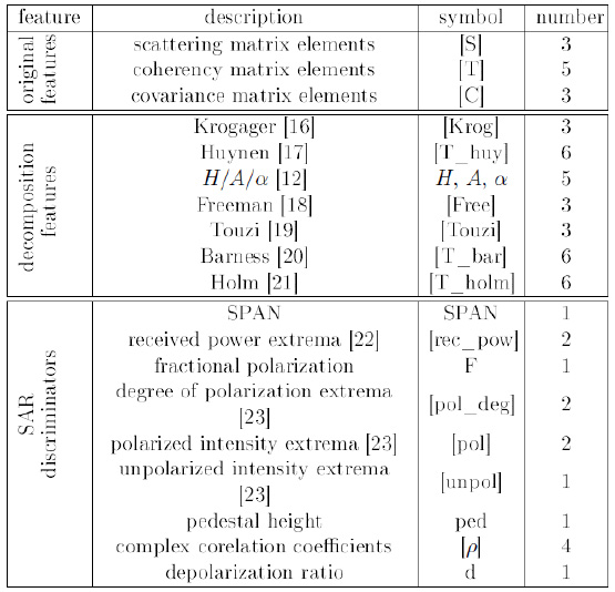
Two Radarsat-2 images acquired in fine quad-polarized mode were chosen for this study. The images were collected in leaf-on and leaf-off seasons. The experimental results demonstrated that the neighboring information provides valuable information for the classification of Polarimetric SAR data. The classification results showed that the proposed methodimproves classification accuracy significantly over the baseline methods.
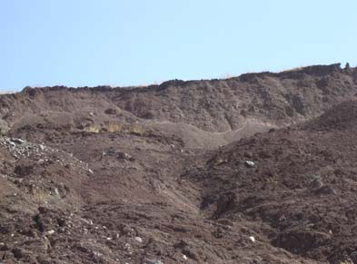
Landslide occurrence is one of the natural disasters which causes great damages annually all over the world and that is the reason, prediction and monitoring of landslides is of great concern. Landslide susceptibility determination relies largely on information which is provided by the landslide inventory maps. Therefore, precise land displacement determination can be regarded as one of the preliminary steps towards a more reliable landslide prediction.

A comparison between the seismicity and active faulting density maps indiactes that a good spatial correlation can be observed between these two parameters. It probably means that active faults are the main seismogenic sources responsible for generating earthqukes in this region. The good consistency observed between the seismogenic zoning map presented in this research and the results of the previous works indicates that the spatial analysis techniques can reliably be used for seismic hazard regionalization and identifying seismogenic hazardous zones in seismically active regions.

Ali Javidaneh, Mohammad A. Rajabi, Shima Rahmatizadeh
Ali Javidaneh
Graduate students of GIS
Department of Surveying and Geomatics Engineering,
College of Engineering,University of Tehran
Tehran, Iran
ajavidaneh@ut.ac.ir
Shima Rahmatizadeh
Graduate students of GIS
Department of Surveying and Geomatics Engineering,
College of Engineering, University of Tehran
Tehran, Iran
sh_rahmat@ yahoo.com
Mohammad A. Rajabi
Associate professor of GIS
Department of Surveying and Geomatics Engineering,
College of Engineering, University of Tehran
Tehran, Iran
marajabi@ut.ac.ir
KEYWORDS
Urban Growth, Cellular Automata, neighborhood …
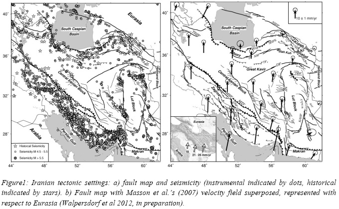
Large scale seasonal atmospheric correction will be investigated using ERA-Interim meteorological model and GPS data. A twisted plane is also fitted to remove orbital errors. To investigate the long wavelength tectonic signal due to interseismic strain accumulation, a time series analysis of the selected Images has been done on a pixel basisin order to enhance signal to noise ratio affected by remaining atmospheric signal.

To this end, spatial information
from IKONOS panchromatic image and spectral information from IKONOS multispectral
image was employed. Spatial resolutions of these images are 1m and 4m and the numbers
of bands are 1 and 4, respectively. The validity of the proposed method was substantiated
through comparison of IKONOS original image to the reconstructed image.

The Satellite Navigation solution is the most preferable, effective and economic aid to various Low and Medium Grade Inertial Sensors in order to get better Navigation accuracy for medium and long duration of navigation solutions. The navigation data from INS and Sat. Receiver at different intervals is synchronized and fused together by using Kalman Filter algorithm so as to obtain precise Navigation solution as long as Sat.




 (5.00 out of 5)