Articles in the Articles Category

November 2023
GEOINT Innovation Summit
1-2 November 2023
National Harbor, Maryland, USA
https://geoint.dsigroup.org
43rd INCA International Congress
6-8 November 2023
Jodhpur, Rajasthan.
https://43inca.org
Trimble Dimensions 2023
6-8 November
Las Vegas, USA
www.trimble.com
GoGeomatics Expo
6-8 November 2023
Calgary, …
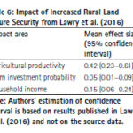
Land tenure security is a critical government service that has repercussions on agricultural productivity, housing development, business investment, and the development of urban areas. The present study presents a cost-benefit analysis of tenure security in Sub-Saharan Africa. Readers may recall that we published the first part of the study in September 2023 issue of Coordinates. …
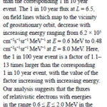
In this study, an extreme value analysis is condcuted of the daily average relativistic electron flux in GPS orbit as a function of position and energy using data from the US NS41 satellite from 10 December 2000 to 25 July 2020
Nigel P. Meredith
British Antarctic Survey, Natural Environment Research Council, Cambridge, United Kingdom
Thomas E. Cayton
Santa Fe, …

The disasters that recently hit Morocco and Libya
Are different in nature,
But they remain same in terms of deaths and devastations.
The victims, as generally happens in such situations,
Were largely left to fend for themselves
The trauma of the affected,
Though, will take a long time to heal,
The world is quick …

Says Sherman Lo, President of the Institute of Navigation (ION). He shares his views on a range of issues in an interview with Coordinates
Sherman Lo
Senior research engineer at the Stanford GPS Laboratory. He also is executive director of the Stanford Center for Position Navigation and Time (SCPNT) and a Stanford instructor. His research work focuses …
October 2023
FIG COMMISSION 7 Annual Meeting 2023
2-4 October
The Netherlands
figcommission7@fig.net
Asian Conference on Remote Sensing (ACRS 2023)
30 October to 3 November
Taipei, Taiwan
https://acrs2023.tw
Intergeo 2023
10-12 October
Berlin, Germany
www.intergeo.de
United Nations/Finland Workshop on the Applications of GNSS
23 – …
Land tenure security is a critical government service that has repercussions on agricultural productivity, housing development, business investment, and the development of urban areas. The present study presents a cost-benefit analysis of tenure security in Sub-Saharan Africa. We present this study in two parts. The first part focusses on the cost …

The results conclude that both Indonesia and Malaysia still face land registration issues
Ricco Survival Yubaidi
Faculty of Law, Universiti Kebangsaan Malaysia, Malaysia
Mazliza Mohamad
Faculty of Law, Universiti Kebangsaan Malaysia, Malaysia
Saidatul Nadia Abd Aziz
Faculty of Law, Universiti Kebangsaan Malaysia, Malaysia
Abstract
Every country has its land policy system. Indonesia employs deeds registration which refers to the Basic Agrarian Law (BAL) …

In this article, the results obtained assessing the Galileo HAS performance at high latitudes in a period of intense ionospheric activity during the ongoing 25th solar cycle are presented
Melania Susi
Ph.D. in Engineering Surveying and Space Geodesy from the University of Nottingham, UK, where she was also a Marie Curie fellow. After being a scientific technical …
September 2023
Commercial UAV Expo
5-7, September 2023
Las Vegas, USA
https://www.expouav.com
ION GNSS+ 2023
11-15 September
Denver, Colorado, USA
www.ion.org
European Lidar Conference (ELC)
13 – 15 September
Cluj-Napoca, Romania
https://enviro.ubbcluj.ro
DroneX Trade Show & Conference 2023
26-27 Septembe
London, United …


 (5.00 out of 5)