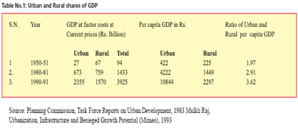
Rural development may be defined as structural changes in the socio-economic situation to achieve improved living standard of low-income population residing in rural areas and making the process of their development self sustained. It includes economic development with close integration among various sections and sectors; and economic growth specifically directed to the rural poor. In fact, it requires area based development…

Leica MobileMatriX v1.51 launched
Leica MobileMatriX is said to support a Multi-Sensor GIS. Within a Multi- Sensor GIS fi eld crews can attach several sensors – TPS, GPS, Levels and Laser Range Finders – at the same time and also can measure with various sensors simultaneously. Multi-Sensor GIS is an emerging trend for mobile GIS and mapping applications.
Leica also announces the upcoming release of Leica GradeSmart 3D (V5.2), a smart machine automation dozer and grader solution for the construction industry. It will introduce new features and improvements designed to enhance speed of operation, support and usability and streamlining of the data transformation process.
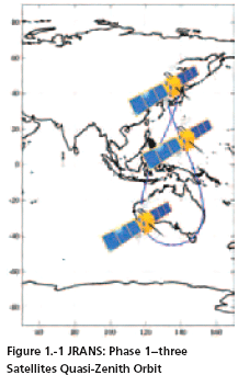
In the 1970s, the US Department of Defense began GPS development as a military force enhancer. In 1983, President Reagan offered GPS civil services to the world, free of direct charges, as a result of the KAL007 disaster. This global offer sparked widespread civil use of GPS and significant investment in civil GPS technologies, to include GPS civil augmenting satellites (e.g. US Wide Area Augmentation System (WAAS), European…

Galileo to be scaled down?
The Financial Times claims the EU may be forced to operate the Galileo constellation with fewer than the currently proposed 30 satellites. The FT quotes Philippe Busquin, a former European research commissioner who now oversees the Galileo project as a member of the European Parliament as saying: ‘It’s not clear that we really need 30 satellites. We could certainly make Galileo a success with 24 or 25.’ Jack Metthey, a director handling research in the European Commission, also describes the Galileo budget situation as ‘very, very tight’, adding: ‘Having less satellites would certainly help address the money issue.’’ However, it is acknowledged that a reduction in the number of satellites could undermine the quality of the system, by reducing coverage and precision, two of Galileo’s trump cards as a 21st- Century constellation. www.rin.org.uk
May 2006
4th Taipei International Conference on Digital Earth
25- 26 May, Taiwan, Taipei
derc@mail.pccu.edu.tw
http://deconf.pccu.edu.tw/
June 2006
ICORG …

A nautical chart is a medium of information and tool for safe maritime navigation. It is the chief nautical instrument for ocean route planning and safe navigation. With the time not only the user’s requirements have increased, but also the advancement in the expertise in the field of nautical cartography has resulted in better product in the most useful way. With the advent of modern cartography, chart contents are stored in…
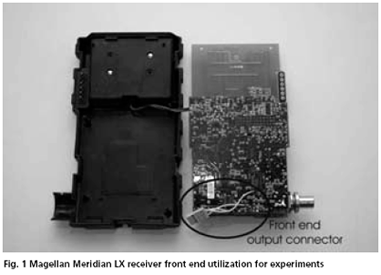
Many researchers and R&D laboratories in the world deal with the design of the software-based or experimental GNSS receivers using digital signal processing for work and experiments with received navigational signals. These concepts have one in common: the necessity of use of some analogue RF part before conversion of the signal to the digital domain. The problem of the RF front end design of the experimental or special purpose navigation receivers has to be solved. It is not an easy task as can be seen from many papers and conference contributions. The aim of this paper is analysis of the possibility of such GNSS RF front end design. We will discuss the following three main approaches
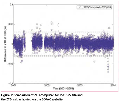
Atmospheric water vapour estimation from the GPS data, surface total pressure and the mean tropospheric temperature is the most cost effective method which gives all weather good spatio-temporal coverage. Precipitable Water Vapor (PWV) in the atmosphere can be estimated from GPS data by determining the travel time delay of GPS radio signals through the troposphere. Water vapour is already identified as…




 (5.00 out of 5)