
BSNL Cellone launches pilot project in Andhra Pradesh
The BSNL cellone has taken up a pilot project in Andhra Pradesh, India to develop location-based services for cellone subscribers. A gamut of services like Industry “Where Am I” information by various industry services will be provided. Once successful, the services will be introduced in entire South India, said J V Reddy, General Manager, Cellone services, A P Telecom. www.hindu.com

China has a vast expanse of land with intertwining rivers and mountains, abounds in lakes and reservoirs. The survey of rivers and lakes as well as the protection and exploitation of these resources plays an important role in Chinese economy. Cross-section survey of water bodies is a key part in hydrographic engineering survey. Traditional methods of cross section survey of a river such as theodolite intersection, theodolite stadia, electronic distance measurement, depth-surveying bar, leadline, handlead survey and echo sounder are the main methods used for water bathymetry. These methods are not only prone to the inaccuracy of instruments, distances, weather conditions, intervisibility and communication device, but also involved in tedious workload which leads to low efficiency. Some unfavorable factors such as the flow of the water and the nonlinear movement of the surveying ship make measuring the depth of the water more difficult. Lack of skills and cooperation among surveyors might result in a low accuracy in the position fix of cross-section points, thus further affects the quality of cross-section survey of the river. The application of real-time kinematic (RTK) GPS positioning technique has opened a new avenue for the crosssection survey of rivers (Wu, 2005). Simultaneous utilization of RTK GPS technology and the shipboard sounding method (e.g. digital depth sounder) will greatly improve the accuracy and efficiency of cross-sectioning survey of rivers(Qiu and Fong, 2002; Qiu 2004; Zhang et al, 2002).

I am delighted to participate in the 26th Congress of the Indian National Cartographic Association (INCA). My greetings to the organizers, delegates of the Conference, cartographers, scientists and technologists, users of cartographic products and distinguished guests.
India has a vision of transforming itself into a developed nation before 2020. There are number of missions which need inputs from cartography technologies that will certainly accelerate the process of development. The programme such as Bharat Nirman Programme including PURA (Providing Urban Amenities in Rural Areas), networking of rivers, infrastructure development in 63 cities through Jawaharlal Nehru Urban Renewable Mission, mapping of earthquake prone areas and recurring floods in north Bihar and Assam require vital inputs at the stage of planning and implementation level. The mission of INCA should be to assist the implementation of developed India vision using their core competence in cartography in partnership with ISRO, NRSA, Survey of India, State Remote Sensing centers, Thematic map making organizations, Indian Remote Sensing Industries, Academia, Research Institutions and other IT organizations. Hence, I would like to talk to you on the topic “Cartographers: Partners in National Development”. Let us now look at some typical requirements of rural and urban development programmes of the nation, where cartographers are major partners.

By 1840 Everest was beginning to think of retiring. He was reaching completion of the Great Arc which was his initial aim but after that he had no further plans that would keep him in India. The last link in the Arc was the remeasurement of the Bidar …
There is a need to make available high resolution digital maps produced in India.
There is a need to place them on a website
There is a need to create a virtual Earth for India for easy access to its citizens.
There is a need to do this in a time bound manner with …
January 2007
Second Asia Pacific Conference for ESRI Users
18-19 January 2007
The Taj Palace Hotel …

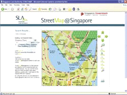
Singapore Land Authority puts map-based land ownership information on the Net
Imagine: you want to know whether a plot of land or a building is state or privately-owned in order to tip-off a case of mosquitoesbreeding, overgrown or fallen trees, illegal parking, noise pollution, or even rubbish dumping. Imagine: you are interested to rent space and …


Map the earth to enrich the globe
DR A P J ABDUL KALAM
River cross-section surveying using RTK Technology BENLIN XIAO, FENGMING WAN, CHANGQING WU AND KEFEI ZHANG
Is definition of WGS 84 correct?
MUNEENDRA KUMAR AND JAMES P REILLY
Using Assisted-GNSS to locate handsets in wireless networks DR NEIL HARPER
GIS in local government ALLAN K BARNES


 (5.00 out of 5)