

India launches nationwide CORS
Union Minister of State (Independent Charge) Science & Technology, Dr Jitendra Singh launched state-of-art latest National Survey Network. The nationwide “Continuously Operating Reference Stations” (CORS) Network. It will be operated by the Survey of India, which has set up more than 1,000 CORS …
Prof M S Swaminathan,
A plant geneticist, agronomist, agricultural scientist,
An advocate of sustainable agriculture,
A proponent of the use of technology in general, and geospatial in particular,
With a caution “not to worship technology, but the outcome one desires”,
And a key architect of India’s ‘green revolution’
Who also warned against ‘greed revolution’ A
nd …
November 2023
GEOINT Innovation Summit
1-2 November 2023
National Harbor, Maryland, USA
https://geoint.dsigroup.org
43rd INCA International Congress
6-8 November 2023
Jodhpur, Rajasthan.
https://43inca.org
Trimble Dimensions 2023
6-8 November
Las Vegas, USA
www.trimble.com
GoGeomatics Expo
6-8 November 2023
Calgary, …
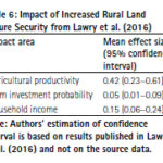
Land tenure security is a critical government service that has repercussions on agricultural productivity, housing development, business investment, and the development of urban areas. The present study presents a cost-benefit analysis of tenure security in Sub-Saharan Africa. Readers may recall that we published the first part of the study in September 2023 issue of Coordinates. …
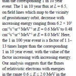
In this study, an extreme value analysis is condcuted of the daily average relativistic electron flux in GPS orbit as a function of position and energy using data from the US NS41 satellite from 10 December 2000 to 25 July 2020
Nigel P. Meredith
British Antarctic Survey, Natural Environment Research Council, Cambridge, United Kingdom
Thomas E. Cayton
Santa Fe, …
Volume XIX, Issue 9, September 2023
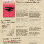
Testing the Galileo High Accuracy Service (HAS) at a High Latitude and under Ionospheric Scintillation
Melania Susi, Daniele Borio, Althaf Azeez, Jihye Park, Kinga Wc˛ zka and Ignacio Fernandez-Hernandez
Land registration acceleration in Indonesia: lessons learnt from land registration system in Malaysia
Ricco Survival Yubaidi, Mazliza Mohamad and Saidatul …

The disasters that recently hit Morocco and Libya
Are different in nature,
But they remain same in terms of deaths and devastations.
The victims, as generally happens in such situations,
Were largely left to fend for themselves
The trauma of the affected,
Though, will take a long time to heal,
The world is quick …

Says Sherman Lo, President of the Institute of Navigation (ION). He shares his views on a range of issues in an interview with Coordinates
Sherman Lo
Senior research engineer at the Stanford GPS Laboratory. He also is executive director of the Stanford Center for Position Navigation and Time (SCPNT) and a Stanford instructor. His research work focuses …
October 2023
FIG COMMISSION 7 Annual Meeting 2023
2-4 October
The Netherlands
figcommission7@fig.net
Asian Conference on Remote Sensing (ACRS 2023)
30 October to 3 November
Taipei, Taiwan
https://acrs2023.tw
Intergeo 2023
10-12 October
Berlin, Germany
www.intergeo.de
United Nations/Finland Workshop on the Applications of GNSS
23 – …


 (5.00 out of 5)