

In the rapidly changing economic, technological, political, and social environment that characterises the world as we see it in the 21st Century, every profession faces major challenges, surveying being no exception. While some of these challenges are common across all professions, others are specific to the surveying community. In this discussion I choose to separate the challenges facing the surveying profession into these two categories…
September 2009
Benetley Be connected Online Seminars
September to November
http://bentley.com/BeConnected
October 2009
European Navigation Event 2009
6 October
Houten, The netherlands
http://www.navigationevent.com

says Dr V Jayaraman, Director, National Remote
Sensing Centre, Indian Space Research Organisation,
in an exclusive interview with Coordinates magazine
on ‘Bhuvan’
How do you envisage the role of Bhuvan?
The role is very clear; it is an Indian Earth Observation visualisation portal. Over the past two decades, ISRO has spearheaded myriad unique applications …
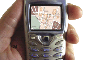
LBS appear to be one of the next natural steps in our move towards a truly unwired permanently connected society
The past decade has seen a quantum jump in mobile usage driven by two factors – one on the basic premise that almost everyone talks and walks and secondly, the underlying technology that has enabled this …
INDUSTRY | LBS | GPS | GIS | REMOTE SENSING | GALILEO UPDATE
wireless adapter can take advantage of its positioning technology and locate a user. Users
Opera Software and Skyhook Wireless …
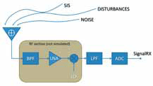
The current panorama of navigation satellite systems is rich of proposals for novel modulations and bands, to be prospectively used in the current and incoming systems. In this perspective, the know-how on the inherent nature of signals and systems is a fundamental resource to proactively cope with the multiple aspects of interaction and integration among signals, services and applications…

Of course, it would be extremely rare, when any GPS surveying and/ or “navigating” to the North Pole is undertaken. One such opportunity occurred In April 2005. British explorer Tom Avery in his effort(s) to recreate Adm. Robert Peary’s epic journey of April 1909 to North Pole took GPS to navigate himself…

Indian Institute of Surveying and Mapping (IISM) is the country’s premier institution for human resources development in the realm of surveying and mapping in its modern incarnation. IISM recognizes that the cutting edge in the process of development is information dissemination. Hence, its efforts of generating awareness among various organization and training its manpower in modern trends in Surveying & Mapping like GPS, Total Station,…
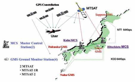
The Multi-functional Satellite Augmentation System (MSAS) is a Japanese Satellite Based Augmentation System (SBAS) [1] which provides Differential GPS (DGPS) corrections and is designed to supplement GPS by reporting and monitoring the reliability and accuracy of GPS signals in real time. MSAS consists of two satellites, (MTSAT-1R at 140E longitude and MTSAT-2 at 145E longitude), four Ground Monitor Stations (GMS), two Master Control Stations (MCS),…

Could you highlight the strengths of Vexcel Imaging large and medium format camera’s for our readers.
The strength of Vexcel is outstanding market knowledge, unparalleled technical experience and the attitude for innovation, all combined to maximize the customer benefi t of our products. Vexcel entered the market of digital large format aerial cameras in 2004, about three years later than the competition with a new concept, the UltraCam. Since then we have increased our market share constantly and became the market leader quickly – we have sold more than 125 UltraCams and additionally quite some camera upgrades. Obviously the market has decided for frame cameras and has made the UltraCam the most successful large format camera series.


 (5.00 out of 5)