

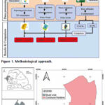
This paper outlines the journey of permanent survey marks, from manufacture via distribution and preparation of locality sketch plans through to their initial digital occurrence on public record.
Michael London
Manager SCIMS & CORS at DCS Spatial Services, NSW Department of Customer Service, in Sydney, Australia.
Dr Volker Janssen
Geodetic Surveyor in the Geodesy & State Adjustment team at …
The result from the GNSS processing method achieved the best performance in terms of absolute error evaluation
Mouhamadou Moustapha Mbacké Ndour
UFR-SI, University of Iba Der Thiam, Thiès, Senegal
Papa Matar Sylla
Holding Gueye, Dakar, Senegal
Alphousseyni Ndonky
UFR-SI, University of Iba Der Thiam, Thiès, Senegal
Babacar Faye
Simon & Christiansen Afrique (S.C.A), Dakar, Senegal
Abstract
The spatial representation of the Earth’s surface, as well …

The analysis performed in this report is solely the author’s work and his opinion.
Narayan Dhital
Actively involved to support international collaboration in GNSS related activities. He has regularly supported and contributed to different workshops of the International Committee on GNSS (ICG), and the United Nations Office for Outer Space Affairs (UNOOSA). As a professional employee, the …

As we architect the next generation of Research Projects and National Health Data Stacks, our conclusion must be rooted in a “Phy-gital” reality where technology does not replace the Physician or experience, but empowers them with planetary-scale health insight intelligence.
Dr. Mukund Kadursrinivas Rao
Is an internationally recognized leader in space and geospatial technologies, with deep multidisciplinary …

Volume 22, Issue 4, April 2026
GNSS Constellation Specific Monthly Analysis Summary: March 2026
Narayan Dhital
The effect of smart contracts (blockchain technology) on Jordan’s land registry and survey department for
sustainable development
AbdelKarim Fawwaz AlBataineh
Maps – Connecting the past, present and future
Ashok Kumar Jain
My Coordinates
EDITORIAL
News
IMAGING | GNSS | GIS | INDUSTRY
CALENDAR
May 2026 – November 2026
Advertisers …

A courtroom in the United States,
Is now confronting a long-standing question.
Did social media merely host behaviour or actively shape it?
As Mark Zuckerberg defends Meta,
The issue extends beyond one company.
It is about the architecture of attention.
Past goals to maximise user engagement now face legal scrutiny.
Design choices that may amplify …
May 2026
GeoIgnite 2026
11 – 13, May
Ottawa, Canada
https://geoignite.ca
IGSM 2026
11 – 16 May
Zagreb Croatia
https://igsm.net
EUROGEO conference
21 -223, May
Tilburg, Netherlands
www.eurogeography.eu
GISTAM 2026
21-23 May
Benidorm, Spain
https://gistam.scitevents.org
FIG 2026
24 – 29 May
Cape Town, South Africa
https://fig2026.org
June 2026
ICCGIS 2026
14 – 19 June 2026
Nessebar, Bulgaria
https://iccgis.cartography-gis.com/
4th Geospatial & Space Technology MENA Forum
24 – 25 June 2026
Dubai, United Arab Emirates
https://menageospatialforum.com/
August 2026
13th IGRSM Conference 2026
05 – 06 August
Kuala Lumpur, …
Septentrio extends its boxed receiver range with AsteRx EB
Septentrio announces a new enclosed multi-frequency GNSS receiver: AsteRx EB. Its IP67 enclosure protects the receiver from harsh weather conditions, while built-in advanced GNSS+ algorithms ensure reliable operation in environments that are challenging for GNSS, such as areas with foliage or near GNSS interference sources. The …
Survey to determine highest mountain peak begins
Survey of Bangladesh has taken initiative to determine the country’s highest peak. It will conduct survey in the Ruma and Thanchi upazilas of Bandarban district. The survey conducted using modern geodetic methods and advanced GNSS technology. International standards to determine the height of the country’s highest peak above …
EASA and EUROCONTROL publish joint Action Plan
The European Union Aviation Safety Agency (EASA) and EUROCONTROL published a joint Action Plan designed to strengthen the safety and resilience of European aviation operations amid the growing challenge of GNSS interference.
Key Elements of the Joint Action Plan
Through joint monitoring and data-sharing, EASA and EUROCONTROL aim …


 (5.00 out of 5)