Ali Javidaneh, Mohammad A. Rajabi, Shima Rahmatizadeh
Ali Javidaneh
Graduate students of GIS
Department of Surveying and Geomatics Engineering,
College of Engineering,University of Tehran
Tehran, Iran
ajavidaneh@ut.ac.ir
Shima Rahmatizadeh
Graduate students of GIS
Department of Surveying and Geomatics Engineering,
College of Engineering, University of Tehran
Tehran, Iran
sh_rahmat@ yahoo.com
Mohammad A. Rajabi
Associate professor of GIS
Department of Surveying and Geomatics Engineering,
College of Engineering, University of Tehran
Tehran, Iran
marajabi@ut.ac.ir
KEYWORDS
Urban Growth, Cellular Automata, neighborhood …

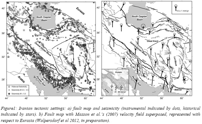
Large scale seasonal atmospheric correction will be investigated using ERA-Interim meteorological model and GPS data. A twisted plane is also fitted to remove orbital errors. To investigate the long wavelength tectonic signal due to interseismic strain accumulation, a time series analysis of the selected Images has been done on a pixel basisin order to enhance signal to noise ratio affected by remaining atmospheric signal.

To this end, spatial information
from IKONOS panchromatic image and spectral information from IKONOS multispectral
image was employed. Spatial resolutions of these images are 1m and 4m and the numbers
of bands are 1 and 4, respectively. The validity of the proposed method was substantiated
through comparison of IKONOS original image to the reconstructed image.
The X900+ is proposed in various bundled packages to fit end users’ need with a choice of various data collection software (CHC’s Landstar and Carlson’s SurvCE) and handheld controllers (CHC’s LT30 and Getac PS236).
Spirent Communications has launched new simulation software that combines inertial MEMS sensor with multi-GNSS (GPS, GLONASS, etc.) testing. SimSENSOR includes trajectories that embed representative human motion gestures, such as arm movements. In additon MEMS noise models and errors such as bias and drift are also available under user control. The software can test fusion algorithms that take inputs from a large variety of sensors, including accelerometers, gyroscope, magnetometer, digital compass and barometric height sensors.
European Commission vice president Antonio Tajanihas unveiled a new service intended to make satellite data more reliable. The European Data Access Service (EDAS) will make data from the European Geostationary Navigation Overlay Service (EGNOS) available on the Internet. As a result, people will be able to access this GPS data from hand-held devices, Tajanisaid, improving the accuracy of things like high-precision fertiliser spraying, automatic road-tolling, fl eet management, inland waterway navigation, dangerous goods transportation or accurate area measurement.
Esri has joined the ocean business alliance World Ocean Council (WOC) and will support its international initiatives for sustainable development and conservation of the ocean. Esrichief scientist Dawn Wright will share her geospatial expertise with WOC’s Coastal and Marine Spatial Planning (CMSP) and Ocean Science working groups. WOC members are oil and gas, seafl oor mining, shipping, fisheries, aquaculture, tourism, and offshore renewables companies.

DigitalGlobe and GeoEye have announced that the boards of directors of both companies have unanimously approved a defi nitive merger agreement under which the companies will combine in a stock and cash transaction valued at approximately $900 million. The combination of DigitalGlobe and GeoEye will create a global leader in earth imagery and geospatial analysis with a more diversifi ed revenue base, a superior fi nancial foundation and signifi cant growth potential.


 (5.00 out of 5)