| Mycoordinates | |
Managing land information
|
||||
|
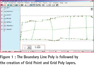
LAND forms important part of development activity. Land revenue is one of the sources of income for state governments. It may come from land holdings by private individuals, real estate transactions or other natural resources being tapped by various sections of the society. Hence, creation of a Land Information Management System involves: * Collection and depiction of accurate information on boundaries, land holdings and ownership, with reference to other spatial information. A LIMS is a computer system stored with spatial data pertaining to land parcels which can be easily retrieved, received and sent, for depiction, query, analysis and manipulation for arriving at judicious decisions. The LIMS should also generate reports and outputs of the analysis which is easy to handle and independently meaningful. Development of a LIMS involves the following: 1. Data Collection. It is important at this stage to understand the basic issues involved in developing an effi cient LIMS. These basic issues are: * Magnitude of the basic tasks in a cadastral system – number of parcels to measure and register. Status of the system at presentCadastre in India is a State Subject. The respective state governments have their own system of collection, depiction and maintenance of land information. Cadastral records form the input to assess land revenue. Most of these records have been developed by surveys carried out more than 50 years before. Positional information and measurements Measurements are not on a national framework. Different techniques were adopted by government agencies while initially building these records. Though at the time of these surveys, the techniques were modern, in the present context, they are outdated and burdened with errors. Descriptive and numerical information recorded in fi eld have been converted into graphical records. These have been prepared decades ago and not updated. They have the following drawbacks:- 1. The field and graphical records are in a mutilated condition. Attribute information The land use information is not updated from time to time. This leads to under valuation of the holdings leading to loss in revenue during transactions. In most of the states, the land administration is managed by using hard copy revenue data either in the form of maps or descriptive documents. The information has following drawbacks: * They are outdated by decades and hence the government is undergoing loss due to incorrect assessment of taxes. What needs to be doneIt is essential that creation of Land Information Management System is done with the following approach: 1. State level and National level connectivity. Need for national connectivityCadastral records need to be corrected for creation of a scientifi cally designed Sustainable LIMS. Correction cannot be done in an ad-hoc manner because public will have no faith in the system. Hence it is necessary that the records are created afresh, by actual survey on the ground. During the process, most modern methods of survey should be adopted so that the errors in the records due to inconsistent methodology are removed. While doing so, if the national connectivity can be achieved, it will be easy for integration of the data and analysis on a national scenario. There is also requirement to streamline the procedures in carrying out the fi led data collection so that inconsistency can be removed to the maximum extent. (Figure -1) |
||||


 (No Ratings Yet)


