| Mycoordinates | |
Managing land information
|
||||
|
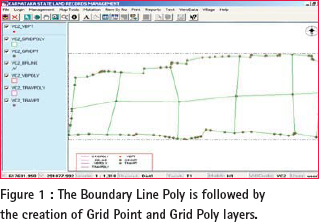
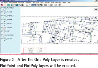
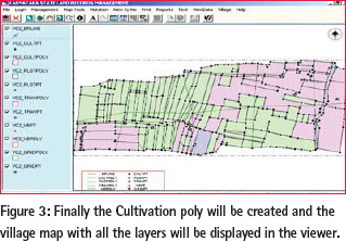
LAND forms important part of development activity. Land revenue is one of the sources of income for state governments. It may come from land holdings by private individuals, real estate transactions or other natural resources being tapped by various sections of the society. Hence, creation of a Land Information Management System involves: * Collection and depiction of accurate information on boundaries, land holdings and ownership, with reference to other spatial information. A LIMS is a computer system stored with spatial data pertaining to land parcels which can be easily retrieved, received and sent, for depiction, query, analysis and manipulation for arriving at judicious decisions. The LIMS should also generate reports and outputs of the analysis which is easy to handle and independently meaningful. Development of a LIMS involves the following: 1. Data Collection. It is important at this stage to understand the basic issues involved in developing an effi cient LIMS. These basic issues are: * Magnitude of the basic tasks in a cadastral system – number of parcels to measure and register. Status of the system at presentCadastre in India is a State Subject. The respective state governments have their own system of collection, depiction and maintenance of land information. Cadastral records form the input to assess land revenue. Most of these records have been developed by surveys carried out more than 50 years before. Positional information and measurements Measurements are not on a national framework. Different techniques were adopted by government agencies while initially building these records. Though at the time of these surveys, the techniques were modern, in the present context, they are outdated and burdened with errors. Descriptive and numerical information recorded in fi eld have been converted into graphical records. These have been prepared decades ago and not updated. They have the following drawbacks:- 1. The field and graphical records are in a mutilated condition. Attribute information The land use information is not updated from time to time. This leads to under valuation of the holdings leading to loss in revenue during transactions. In most of the states, the land administration is managed by using hard copy revenue data either in the form of maps or descriptive documents. The information has following drawbacks: * They are outdated by decades and hence the government is undergoing loss due to incorrect assessment of taxes. What needs to be doneIt is essential that creation of Land Information Management System is done with the following approach: 1. State level and National level connectivity. Need for national connectivityCadastral records need to be corrected for creation of a scientifi cally designed Sustainable LIMS. Correction cannot be done in an ad-hoc manner because public will have no faith in the system. Hence it is necessary that the records are created afresh, by actual survey on the ground. During the process, most modern methods of survey should be adopted so that the errors in the records due to inconsistent methodology are removed. While doing so, if the national connectivity can be achieved, it will be easy for integration of the data and analysis on a national scenario. There is also requirement to streamline the procedures in carrying out the fi led data collection so that inconsistency can be removed to the maximum extent. (Figure -1) |
||||
|
||||
What is required?The salient requirements will be: Urban areas In urban areas, the land value is quite high and the spatial data is multi-fold requiring different types of data for different purposes, which the LIMS should be able to generate from the information stored. Data collected to meet mapping standards on 1:1,000 scale with height accuracy of 0.5 meters should be suffi cient for most of the land management purposes. For example:- * spatial data showing accurate footprints of buildings with road network will be required for Location Based Services (LBS), like telecom, gas, power, internet, cable TV, vendors etc. Geographical positional accuracy may not be of great importance, but relative positions should be sufficient. Rural Area In rural area the land value is not as high as urban areas. But, ownership details and plot measurements should be accurate to avoid disputes on ownership and boundary. Data collected to meet mapping standards on 1:5,000 scale with height accuracy of 2 metres should be suffi cient for most of the land management purposes. They should depict:- * village boundaries with road connectivity information from village to village, for the country as a whole is required. Hilly and Forest areas In hilly and forest areas, the land value is not that high. Data collected with mapping standards on 1:10,000 scale with height accuracy of 5 metres should be suffi cient to meet following needs:- * Accurate boundary demarcation and depiction compatible with adjoining village boundary details. |
||||
|
||||
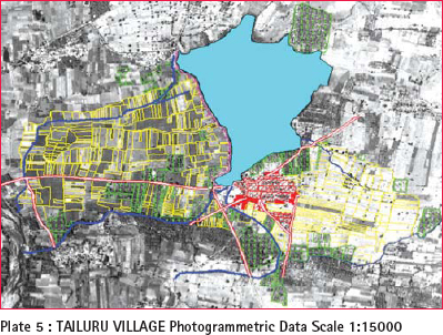
Technology availableDifferent technology available and limitations are discussed in brief below. Ground survey cannot be avoided to build a foolproof record. Depending on the constraints and ground conditions, particular technology can be used. Electronic Total Station Survey Establishing control by traverse and later distance measuring is done using the total stations. This replaces the conventional theodolite and chain measurements or plane table traverse for establishing control. Detail survey is done by digital recording of data instead of FMBs of conventional system. The data can be downloaded, processed and records created. This process is time consuming. Global Positioning System and Total Station GPS is used for establishing control points required for detail survey in an area. This technique is replacement for the theodolite and traversing method, reducing the efforts and time required for establishing stations and observation. However, clear sky view of about 15° over the instrument is essential for tracking of the navigation satellites. Diffi cult to use in jungle/ tree covered areas. Total station is used for further traversing and detail survey electronically, and process in a computer medium. However in this method, we get accurate records after the entire process is completed. Staged upgradation of records using available records is not possible. This is a time consuming process. Photogrammetric survey combined with GPS, Total Station and ground checking Aerial photo gives a pictorial ground truth and is a proof of ground at the time of photography for times to come. Digital Aerial photographs on 1:25,000 scale are suffi cient to prepare a base map on 1:5,000 scale. However, contiguous area of about 5000 sq km will be economical. For rural area this should be suffi cient. In urban areas where land value is of signifi cance, we require measurement accuracy upto 5- 10cm in a plot of 6metres x 9 metres size. In such areas 1:1,000 scale survey will be required and aerial photo on 1:5,000 will be essential. GPS is used to establish minimum ground control required for photogrammetric survey. A base map will be generated on 1:5,000 scale for rural areas and 1:1,000 scale for cities which can be taken to the ground for ground checking and picking up attribute information. The process can be done in two ways: * Generation of line maps from aerial photo: Using digital photogrammetric technique, line maps can be created which can be taken to ground for incorporating cadastral information and other topographical details. This can be brought back to offi ce and incorporated in the data base. Use of PC Tablet/ Palm top for detail survey and data capture in field The digital line maps prepared in photogrammetry can be stored in PC Tablet/ Palm top and taken to ground to incorporate attribute information, down load to computer and process to get information desired. Certain amount of post processing of data will be required. Airborne Laser Terrain Mapping This technology is very costly but can be used in forest areas to get accurate height. Certain amount of post processing is required. Suggested procedureThe task of creating a LIMS cannot be achieved at one go. It is proposed to achieve the goal in an incremental manner with the following objective:- * Establish National Connectivity and use the work of scanning and computerization done already to superimpose and build fi rst level LIS using line map prepared using geo referenced Aerial Photographs (Figure -5) |
||||
|
||||||||||||
How to achieve the above goalAchieve National Connectivity Survey of India has already undertaken the work of establishing 300 precise GPS stations in India which will be about 100 km apart. Using these points as base, Survey of India will provide GPS stations at about 5km apart ensuring 2 points for each village, which will be prominent points (Tri junctions of village). These points will further be used for establishing dense control by Total station traverse or GPS for plot level survey. Preparation of Image Maps and Line Maps on 1:1,000/1:5,000/1:10,000 scale High Resolution satellite imagery will be used to prepare geo-referenced ortho rectifi ed Image maps for plain areas. Aerial Photographs on scale 1:20,000 will be used for undulating terrain. This will be done by using the 5km apart GPS control points for rectifi cation of the satellite image or aerial photographs. The available village maps, digital or otherwise, will be superimposed on the Image maps. This Image map will be digitized to create Line Maps with topographical features, and plot boundaries as existing in the village map records, to form First Level LIS. The measurements recorded in creating the old records will be linked to the digital records in a GIS environment. This will be completed by Survey of India in two years time. Achieve measurement accuracy by Resurvey of plots using local resources and update the records Survey of India will help State Government to further densify the control by GPS/ Total Station to facilitate village boundary and plot boundary survey. Required Training as Capacity Building Measure can also be imparted. However, Survey of India does not wish to carry out the job of building further cadastral records by ground measurement of plots. This needs to be done by respective state Land records personnel using the GPS points and Line Maps already prepared, to meet legal requirements. Survey of India can render supervision efforts/ technical know how to build the computerized LIS. In a coordinated effort, this process should be completed in 3 years time, as a National Movement. Collection of other attribute Information required for land management A suitable data base form should be devised to collect and record the land information and demographic information which will help assessment of tax and economic status of each plot owner. Information should be collected for each plot and ownership on a well designed format, with a key fi eld which can be used as link between different thematic information for that ownership. This work could be outsourced to some extent, by dividing the forms to different categories of information, so that information required as per statutory requirements could be collected by the Land Records offi cials and other information could be collected by out sourcing. Certain information regarding water source and soil classifi cation can be obtained from the respective organization and incorporated in the data base. Analysis and output The collected information on control, topography and cadastral details can be processed in the computer using a suitable software for getting plot, grid and village map outputs. Other data collected will help in assessment of tax and economic status of the families. Land use information collected will help analysis from local level to national level. By a suitable generalization technique, the integration of topographical maps on small scale may be done using the same information so that the data on cadastral records and topographical maps will be compatible. This will help integration of Natural resources data in the context of National Spatial Data Infrastructure (NSDI). ProposalSurvey of India will take up the project using any of the above mentioned methods/ approach depending on the requirement of the states. It will only extend necessary help in training of persons at state level or technology to the industry, to help creation of a LIMS as follows: PHASE I * GPS Control for National Connectivity in two stages( 100 km apart in stage I and 2 points per village in II Stage): This will be done by Survey of India. PHASE II Achieving measurement accuracy, revision survey and correction of records: The existing line maps generated in Phase I will be used for deriving coordinates and positions of plot boundary as identifi ed on ground and marked on line maps. This will save lot of time and cost of resurvey. Most of the plot boundaries could be identifi ed on the line maps as they are created from the image maps. With training to local level offi cials, this job can be done by Land records offi cials, within their own resources. The measurements so obtained, could be used to correct and update the records. As each village would have properly geo referenced GPS points, there will not be much error in the data so gathered. Minor errors will be adjusted within the village and hence records will match with adjoining plot maps without any diffi culty. Same data will be used to prepare the village, Taluk and small scale maps at higher levels by data integration. Advantages of GPS/Total Station/ Photogrammetric survey and ground checking procedure: This approach will help in :- 1. The existing records in measurement can be used as attribute and first level data can be electronically generated and used. This will take about 2 years for the entire country. Conclusion Survey of India will adopt procedures and technology depending on the need of each state and help in transfer of technology, supervision of work, and build capacity among states and industry to do this gigantic task. It will provide facility in it’s premises for tasks which are of classifi ed nature, like use of photogrammetric techniques. It will also strive to build capacity at local level among people to have a system for systematic and continuous upgradation of information. |
||||||||||||
|
||||||||||||
|



 (No Ratings Yet)


