| GNSS | |
The importance of mitigation of GNSS vulnerabilities and risks
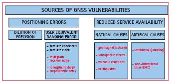
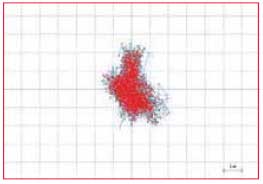
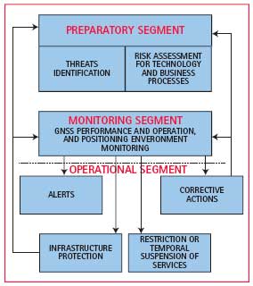
Consciously or not, all humans are navigators, so it is without wonder that satellite navigation has swiftly become a backbone of modern civilisation. All of the sudden, situation awareness and management become significantly improved by introduction of the helpful and inexpensive technology that provides positioning services of unprecedented quality. It is hard to find a technological or socioeconomic systems that has not yet utilised the benefits of integration of satellite navigation systems. The way the transport works is completely changed by utilisation of the GNSS-based traffic management and safety systems on roads (GNSS-based fleet management, eCall in Europe), on the sea (AIS/VTMIS, GMDSS), and in the air (GNSS/GPS/EGNOS as the air navigation systems). Land and asset management segments flourish, while position details of spatial objects can be efficiently mapped to the information landscape. Agriculture benefits enormously from the ability to accurately map the spatial distribution soil data, and devise advanced soil treatment procedures based on evidence. Systems like power distribution networks, mobile telecommunication networks, and the financial systems increasingly take advantage of the ability of satellite navigation systems to provide a very reliable and accurate time synchronisation. Personal navigation has expanded from navigation-only devices to GNSS-enhanced smart-phones, allowing for introduction of the whole segment of location-based services, both commercial (navigating an user to the nearest point of interest, for instance), regulated (road charging service, as an example), and safety-related (E112 and eCall in Europe, and E911 in the US, VIPs’ and disabled individuals tracking). Figure 1: A pleasant day at the Earth’s surface can be at the same time subject to a severe space weather disturbance that signifi cantly deteriorates GNSS performance (Baska, Krk Island, Croatia) The GNSS applications heavily rely upon the performance, availability and robustness of the core GNSS systems. Every deterioration of GNSS performance and operation may cause severe consequences on performance and operation of the GNSSbased technological and socio-economic systems. While not a single applications should rely upon only one fundamental (in many cases: positioning) system, the over-reliance on GNSS is already evident. GNSS vulnerabilities and risks – What can go wrong?Almost everything can go wrong. Position estimation using satellite systems, like the other positioning determination methods, is a measurement-based process. Real world environment often brings many challenges to measurement processes in a form of a set of influencing physical quantities (variables) that caused measurement errors and, consequently, the uncertainty of measurement results. In the case of position estimation using satellite navigation systems, certain scenarios may lead to the complete inability to perform position estimation. In essence, the technology environment of a GNSS comprises four main components: – satellite components – (terrestrial or ground)control component – user equipment component – propagation media. While several components are controllable providing certain prerequisites are met (for instance, satellites will most probably operate as expected in quiet space weather conditions), the others are completely out of any reasonable influence of a GNSS operator. For instance, a sudden ionospheric storm, a part of propagation media environment, is completely out of control of a GNSS operator, leaving the users at risks of getting either an inaccurate position estimate, or not getting any estimate at all. Potential sources of GNSS performance and operation deteriorations and disruptions, summarised in Fig 1, can be considered the causes of GNSS vulnerabilities and risks. More generally, they can be split into two major groups, one consisting of those sources that cause the position estimation errors, while the other gathers sources affecting positioning and timing service availability. Positioning errors (Fig 2) are caused by dilution of precision and the user equivalent ranging error. Dilution of precision results from reduced availability of satellite GNSS signals often caused either by intentional or unintentional obstructions of the sky view. User equivalent ranging error comprises positioning error sources related to satellite and control components (satellite ephemeris and satellite clock errors), user component (multipath and receiver noise errors) and propagation media (ionospheric- and tropospheric-induced errors). The GNSS ionospheric delay is the single most important contributor to the GNSS positioning error budget. Reduced service availability may cause various levels of GNSS disruptions, from limited deterioration of GNSS performance and operation, to complete denial of service. Causes of the reduced service availability may be of natural or artificial origins, as depicted in Fig 1. Geomagnetic storms, significant disturbances of the Earth’s geomagnetic field, and ionospheric storms, considerable modifications of the vertical ionospheric profile, pose particularly important threats to GNSS performance and operation, as revealed by numerous studies conducted worldwide. Caused by space weather (mostly solar) disturbances, geomagnetic and ionospheric storms have global outreach and can last from several hours to several days, while reaching various levels of intensity. In addition, the ionospheric storms may be induced in spatially limited areas by natural processes affecting local distribution of charging particles in the ionosphere, such as volcanic eruptions and earthquakes. Local ionospheric disturbances pose especially dangerous threats to GNSS performance since they often go unnoticed, depending on the region of the world where the local ionospheric storms take place. The intentional causes of GNSS performance deterioration and disruptions are on the rise, especially jamming and spoofing. At the same time and considering increasing demand for radio spectrum, the increased number of nonintentional artificial effects on GNSS performance should be expected. The GNSS vulnerabilities and risks affect different GNSS-based applications in different manners, depending on the quality of positioning service required for particular applications. A commercial information service providing guiding information to the nearest petrol station will not be strongly affected with a sudden increase in position estimation error, while the same will cause serious consequences in the case of positioning for the E112 emergency call. Mitigation of GNSS vulnerabilities and risksWith the wide-spread utilisation of GNSS, and apparent and unavoidable GNSS vulnerabilities and risk in effect, the enhancement of the GNSS resilience through mitigation of GNSS vulnerabilities and risks becomes a necessity for all stakeholders involved in GNSS utilisation: GNSS operators, national authorities responsible for radio spectrum management and protection, GNSS-based systems designers and operators, GNSS-based service providers, regulators, and GNSS and GNSS-based systems and services users. The GNSS operators have already deployed mitigation methods addressing sustainable positioning performance, providing positioning assistance and augmentation services, performance monitoring, and facilitating the improved user equipment design. Still, a considerable space of GNSS vulnerabilities and risk remains uncovered for a very simple reason that GNSS operators cannot control the whole GNSS operation environment. Here we propose a GNSS resilience scheme that comprises all GNSS stakeholders’ actions in an effort to build the sustainable GNSS vulnerabilities and risks mitigation, as depicted in Fig 4. The proposed GNSS resilience scheme is composed of the three segments: – preparatory segment, – monitoring segment and – operational segment. Preparatory segment identifies potential threats to the GNSS and GNSS-based systems and services performance and operation, and assesses the potential technology and business processes disruptions due to GNSS vulnerabilities and risks. In due course, conducting controlled stress tests is highly recommended for agencies, organisations and companies with process that heavily rely on GNSS. As a part of preparatory activities curbing the GNSS vulnerabilities and risks, the establishment of the reasonable and educated utilisation of GNSS arises as an absolute necessity. The users of GNSSbased systems and services must be aware of the limitations of technology and potential GNSS vulnerabilities and risks. The preparatory segment should yield a knowledge base of potential threats, as well as risk assessment and the book of resilience methods and corrective actions for every technology and business process utilising GNSS. Third-party expertise should be considered in conducting the activities related to the preparatory segment of the GNSS resilience scheme.Monitoring segment comprises activities and methods related to continuous monitoring of GNSS performance (accuracy, availability) and operation (satellite health, accuracy of satellite ephemeris and standard ionospheric correction model parameters), as well as positioning environment (space weather and ionospheric disturbances monitoring and forecasting, jamming and spoofing detection). Monitoring activities should be performed in a timely manner and with the spatial distribution of monitoring probes that provide the equal level of the national coverage and the appropriate time margins for initiation of operational activities. In the case of detection of any GNSS risk in effect, the operational segment should be launched. Depending on the quality of risk identification and forecasting quality, the appropriate alert should be issued to the operators of the GNSS-vulnerable systems and services. This will allow for deployment of the internal mitigation procedures, resulted from the activities of the preparatory segment, and may involve temporal reduction of even suspension of vulnerable systems and services that are based on GNSS. Operators of GNSSbased systems and services exposed to GNSS vulnerabilities and risks in effect should consider deployment of corrective actions, such as: closing subsystems temporarily and utilisation of alternative auxiliary systems. Finally, depending on the intensity of threatening conditions, the protective measures maybe implied on national infrastructure (power and telecommunication networks, financial systems etc.) if GNSS performance deterioration may cause the lasting damage. ConclusionGrowing importance of GNSS results in increased vulnerabilities and risks of systems and services utilising the GNSS, and requires risk-aware GNSS deployment. While a number of technology-related mitigation actions have already been deployed and then new and enhanced ones are under development, building the GNSS resilience should be extended to the user segment. National authorities should accept the responsibility for deployment of essential protective and mitigation activities addressing the GNSS-based systems and services of national importance. Operators of commercial and regulated services should do the same in their field of responsibility, at the same time assessing the potential effects of GNSS performance deteriorations and disruptions to their technology and business processes, devising procedures for corrective actions and mitigations. End-users should enhance their awareness of potential threats, vulnerabilities and risks related to GNSS-based systems and services they use, and assess the potential effects on their personal activities. The advanced assessment of potential effects of the GNSS vulnerabilities and risks can be performed by utilisation of the actions including stress tests in controlled positioning environments (either real or simulated). As the result, the case-studies should help to build a dedicated knowledge base. Further consolidation of the acquired experience and knowledge on the effects on the international basis should become a foundation for sustained utilisation of GNSS as a component of national infrastructure. ReferenceAmerican Meteorological Society. (2011). Understanding Vulnerability & Building Resilience. AMS. Washington, DC. Available at: http://bit.ly/rnkRQu Filjar, R. (2008). A Study of Direct Severe Space Weather Effects on GPS Ionospheric Delay. Journal of Navigation, 61, 115-128. Hapgood, M and A Thomson. (2010). Space weather: Its impact on Earth and implications for business. Lloyd’s 360o Risk Insight. London, UK. Available at: http://bit.ly/9Pjk9R John A Volpe National Transport Systems Center. (2001). Vulnerability Assessment of the Transportation Infrastructure Relying on the Global Positioning System. Available at: http://bit. ly/5NTMy8, accessed on 3 May 2010. Thomas, M et al. (2011). Global Navigation Space Systems: reliance and vulnerabilities. The Royal Academy of Engineering. London, UK. Available at: http://bit.ly/feFB2i
|


 (10 votes, average: 4.40 out of 5)


