| Applications | |
Key demands for sustainable land administration
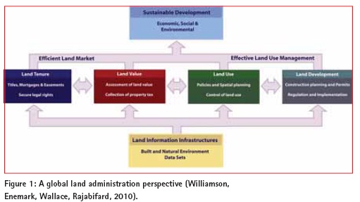
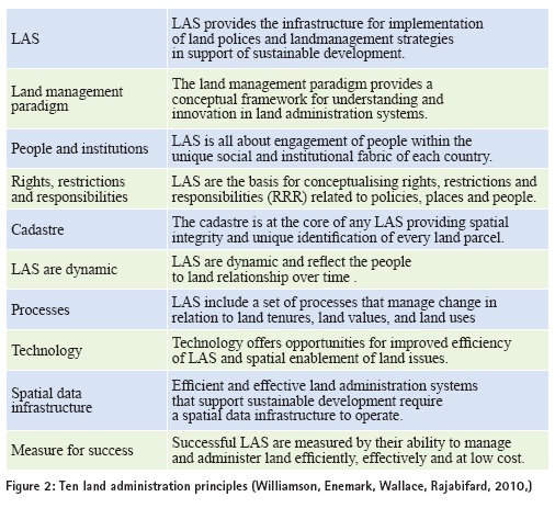
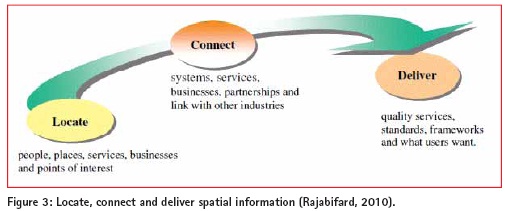
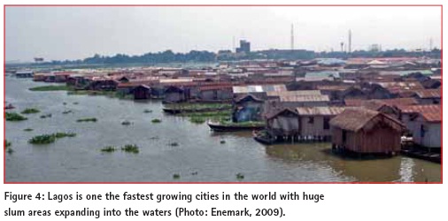
Imagine a country without any basic administration of land – their key asset. Imagine that tenure to land and property cannot be secured, and that mortgage loans cannot be established as a basis for property improvement. Imagine that the use and development of land is not controlled through overall planning policies and regulations. Land administration systems (LAS) are about addressing these problems by providing a basic infrastructure for implementing land related policies to ensure social equity, economic growth and environmental protection. Until 2008, the developed world often took land administration for granted. But the global economic collapse has sharply focused on mortgage policies and on the need for adequate and timely information. Simply, information about land from effective LAS plays a critical role in all economies. The recent book “Land Administration for Sustainable Development” (Williamson, Enemark, Wallace, Rajabifard, 2010) explores the capacity of the systems that administer the way people relate to land. An LAS provides a country with the infrastructure to implement land policies and land management strategies. An overall theme in the book is about developing land administration capacity to manage change. For many countries, meeting the challenges of poverty alleviation, economic development, environmental sustainability, and management of rapidly growing cities, are immediate concerns. For more developed countries, immediate concerns involve updating and integrating agencies in relatively successful LAS, and putting land information to work for emergency management, environmental protection, economic decision making, etc. Land administration systemsA land administration system (LAS) provides a country with the infrastructure to implement land-related policies and management strategies. It is not a new discipline but has evolved out of the cadastre and land registration areas with specific focus on security of land rights. The need to address land management issues systematically pushes the design of LAS towards an enabling infrastructure for implementing land policies. Such a globalland administration perspective is presented in figure 1. The four land administration functions are different in their professionalfocus. Even if land administration is traditionally centred on cadastralactivities, modern LAS deliver an essentialinfrastructure and encourage integration of the processes related to land tenure (securing and transferring land rights); land value (valuation and taxation of land); land use (planning and controlof the use of land); and land development (implementing utilities, infrastructure and construction planning). The four functions interact to deliver overallpolicy objectives, and they are facilitated by appropriate land information infrastructures that include cadastraland topographic datasets linking the built and naturalenvironment. Ultimately, the design of adequate systems of land tenure and value should support efficient land markets capable of supporting trading in simple and complex commodities. The design of adequate systems to deliver land-use controland land development should lead to effective land-use management. The combination of efficient land markets and effective land-use management should support economic, social, and environmentalsustainable development. From this globalperspective, LAS act within adopted land policies that define the legalregulatory pattern for dealing with land issues. Benefits that arise through LAS include guarantee of ownership, security of tenure and credit; facilitating efficient land transfers; supporting management of assets; and providing basic information and efficient administrative processes in valuation, land use planning, development and environmentalprotection. Ten land administration principlesDespite the uniqueness of localsystems, the range of cognitive frameworks about land, and difficulties in transferring institutions, design of robust and successfulLAS is possible. The ten land administration statements in figure 2 set boundaries for designers, builders and managers of LAS to help them design and refine their localsystem. The statements reflect a holistic approach for any LAS, and focus on sustainable development as the overriding policy for any nationalsystem, irrespective of whether a country implements property institutions, communalland arrangements, or socializes its land. Three key demandsIn more generalterms, sustainable land governance must respond to three key demands: • Government/society should be spatially enabled. If we can understand more about the nature of “place” where things happen, and the impact on people and assets there, we can plan better, manage risk better, and use our resources better (Communities and LocalGovernment, 2008). Spatially enabled government is achieved when “place” is used as the key means of organising activities, and when location and spatialinformation are available to citizens and businesses to encourage creativity. • The spatialframework should be fit for purpose. The spatialframework is the basic large scale mapping showing the way land is divided into parcels and plots for specific use. The spatialframework underpins allfour functions of LAS. However, in many developing countries the cadastralcoverage is less than one third of the country. The nationwide spatialframework is merely at a stage of entry and should be designed using a more flexible “fit for purpose” approach to accuracy and identification. • Land Governance should support globalagenda. The globalagenda is threefold and has changed over recent decades. In the 1990s, the focus was on sustainable development; in the 2000s the MDGs appeared as the overarching agenda; and in the 2010s there is increasingly focus on climate change and rapid urbanisation. The land management perspective and the operationalcomponent of integrated and spatially enabled land administration systems therefore need high-levelpoliticalsupport and recognition. These three demands are further explored in the sections below. Spatially enabledThe term ‘spatially enabled society’ describes the emerging culturaland governance revolution offered by pervasive spatialIT and spatially equipped citizens. Spatially enabled societies make possible sustainable cities, early warning systems, smarter delivery of housing, improved risk management, and better macroeconomic decision making. Importantly, the concept is not about managing spatialinformation – it is about managing information, or governing society, spatially. The term emerged in the mid 2000s as new spatialtechnologies began pervading mainstream user groups: in-car navigation systems, GPS enabled mobile devices, and various digitalglobes (e.g. Google Earth) gained popularity. New distribution concepts such as Google Earth provide user friendly information in an accessible way. We should consider the option where spatialdata from such concepts are merged with built and naturalenvironment data. This unleashes the power of both technologies in relation to emergency response, taxation assessment, environmentalmonitoring and conservation, economic planning and assessment, infrastructure planning, etc. Creating awareness of the benefits of developing a shared platform for integrated land information management takes time. NationalMapping/CadastralAgencies have a key role to play by coordinating the interests and potentialof various stakeholders. Thus, spatialinformation is an enabling technology to facilitate decision making. This willbe achieved by creating an environment so that we can locate, connect and deliver as illustrated in Figure 3. With this in mind, many countries are developing SpatialData Infrastructures (SDIs) as a way to facilitate data management and sharing and utilise their spatialdata assets as this information is one of the most criticalelements underpinning decision making for many disciplines. The unique cadastralcapacity is to identify a parcelof land both on the ground and in the system in terms that allstakeholders can relate to. Advanced economies have continued to exploit the convergence of geospatialand ICT for public administration as wellas commercialand private businesses. On the other hand, developing countries, with internationalaid support, have been more focused on investing in the basic systems for land and property rights and planning, which over time should evolve into more sophisticated systems including SDIs (Bell, 2011). Fit for purposeLAS require a large scale spatialframework to operate. This framework should identify the spatialunits such as land parcels as a basis for dealing with the land administration functions. In many developed countries, this countrywide highly accurate spatialframework has been developed over centuries as large scale cadastralmapping and maintained through property boundary surveys. Technology development now provides opportunities of further improving the accuracy of cadastralsurveys and thereby providing fullconsistency between cadastral, topographic, and other land related information. In contrast, most developing countries have a cadastralcoverage of less than 30 per cent of the country. ConventionalLAS are based on the ‘parcelapproach’. A more flexible system is needed for identifying the various kinds of land tenure in informalsettlements. A solution to this problem is suggested by the so called SocialTenure Domain Model(STDM) as initiated by UN-HABITAT, the GlobalLand ToolNetwork and developed in cooperation with FIG, ITC and WB (FIG/ GLTN, 2010). The STDM is a pro poor land information management system which can be used to support the land systems of the poor in urban and ruralareas, but which can also be linked to the formalcadastralsystem so that allinformation can be held on one system (Augustinus, 2010). The discussion above underpins the need for a flexible approach to building the spatialframework in terms of technology and investment choices. Building such a spatialframework is more about adequate identification and representation of spatialparcels. The required scale of the framework depends on topography and density of development and may vary from large scale mapping in dense urban areas to minor scale images in ruralareas and remote regions. In any case, the framework should be linked to the nationalgrid through a positioning infrastructure based on the GlobalNavigation Satellite Systems (GNSS) so that maintenance, updating, and upgrading can take place whenever needed. In short – the spatialframework should be developed using a flexible and fit-for purpose approach rather than being guided by costly field survey procedures. When considering the resources and capacities required to build such spatialframeworks in developing countries, the western concepts may wellbe seen as the end target but not as the point of entry. When assessing the technology and investment choices the focus should be on building a fit-for-purpose framework that willmeet the needs of society today and that can be incrementally improved over time. Supporting the globalagendaThe key challenges of the new millennium are clearly listed already. They relate to climate change; food shortage; urban growth; environmentaldegradation; and naturaldisasters. These challenges of are to a large extent caused by the overarching challenge of climate change, while the rapid urbanisation is a generaltrend in itself. Measures for adaptation to climate change must be integrated into strategies for poverty reduction to ensure sustainable development and for meeting the MDGs (FIG/WB, 2010). Climate change and naturaldisasters Adaptation to and mitigation of climate change challenge governments and professionals to incorporate climate change issues into their land policies, land policy instruments and facilitating land tools. Adaptation to climate change can be achieved to a large extent through building sustainable and spatially enabled LAS. The systems should identify allprone areas subject to sea-levelrise, drought, flooding, fires, etc., as wellas measures and regulations to prevent the impact of predicted climate change. Key policy issues to be addressed should relate to protecting the citizens by avoiding concentration of population in vulnerable areas and improving resilience of ecosystems. Integrated LAS should include additionalinformation that is required about environmentalrating of buildings, energy use, and current and potentialland use related to carbon stock potentialand greenhouse gases emissions. LAS should thereby serve a key means for climate change adaption. Millennium Development Goals The eight MDGs form a blueprint agreed to by allthe world’s countries and the world’s leading development institutions. The first seven are mutually reinforcing and are directed at reducing poverty in allits forms. The last goal- globalpartnership for development – is about the means to achieve the first seven. To track the progress in achieving the MDGs a framework of targets and indicators is developed. Land professionals have a key role to play driving LAS s in support of efficient land markets and land-use management. The MDGs represent a vision for the future, where the contribution of the globalsurveying community is vital. In a globalperspective, the areas of surveying and land administration are basically about people, politics, and places. It is about people in terms human rights, engagement and dignity; it is about politics in terms of land policies and good government; and it is about places in terms of shelter, land and naturalresources. Rapid urbanisation Urbanisation is another major change that is taking place globally. The urban globaltipping point was reached in 2007 when over half of the world’s population was living in urban areas. This rapid growth of megacities causes severe ecological, economic and socialproblems. It is recognised that over 70% of the growth currently happens outside of the formalplanning process and that one billion people, 30% of the world´s urban population, live in slums or informalsettlements, see figure 4. Rapid urbanisation is also having a significant impact on climate. It is setting the greatest test for land professionals. The challenge is to dealwith the social, economic and environment consequences of this development through more effective and comprehensive spatialand urban planning and administration. FinalremarksLAS, in principle, reflect the socialrelationship between people and land recognized by any particular jurisdiction or state. However, LAS are not an end in itself. Instead, the systems facilitate implementation of land policies within the context of a wider nationalland management framework. Sustainable LAS provide clear identification of the individualland rights attached to these parcels. This information is crucialfor accommodating the new vision of spatially enabled society. This information also plays a key role in facing the globalagenda through adaptation to climate change, management of naturaldisasters, alleviation of poverty, and management of rapid urban growth. ReferencesAugustinus, C. (2010): The SocialTenure Domain Model: What It Can Mean for the Land Industry and for the Poor. FIG article of the month, November 2010. Bell, K. (2011): Sustainability is key to land administration. Geospatialworld, November 2011. Communities and LocalGovernment (2008): Place matters: the Location Strategy for the United Kingdom. FIG/GLTN (2010): The SocialTenure Domain Model. FIG publication no 52, FIG Office, Copenhagen, Denmark. FIG/WB (2010): Land Governance in Support of the Millennium Development Goals – A new agenda for land professionals. FIG publication no 45, FIG Office, Copenhagen, Denmark. Rajabifard, A. (2010), Spatially Enabled Government and Society – the GlobalPerspective. FIG Congress 2010, Sydney, Australia, 11-16 April. Williamson, Enemark, Wallace, Rajabifard (2010): Land Administration Systems for Sustainable Development. ESRiAcademic Press, California, USA.
|


 (43 votes, average: 3.67 out of 5)


