Articles in the GNSS – New Category


In the first phase of the Covid-19 crisis, many countries of the European Union (EU) introduced severe measures limiting the free movement of persons and goods across borders. The objective of these measures was the contention of the spreading of the virus…

The impact of COVID-19 is most dramatic in the slow down of workforce training, education, and research at universities
Chris Rizos
Emeritus Professor in the School of Civil and Environmental Engineering and a co-director of the Satellite Navigation and Positioning (SNAP) Lab at UNSW. Chris is presidentelect of the International Union of Geodesy & Geophysics (IUGG)
At first …
China launches last BeiDou satellite
China recently launched the last satellite of the BeiDou Navigation Satellite System (BDS) from the Xichang Satellite Launch Center in southwest China’s Sichuan Province. The satellite, carried by a Long March-3B carrier rocket, is the 30th BDS-3 satellite and the 55th of the whole BeiDou satellite family. The launch marked …

Availability of Ground Control Points for surveying and engineering projects is a major challenge in developing countries including Nigeria…
Isro develops desi atomic clock, to be used in navigation satellites
In a significant development, Indian Space Research Organisation (Isro) has developed an atomic clock that will be used in navigation satellites to measure precise location data. The space agency currently imports atomic clocks from European aerospace manufacturer Astrium for its navigation satellites.
Tapan Misra, …
Russia’s Deputy Prime Minister Dmitry Rogozin has described as politically motivated the USs’ decision to freeze the construction of GLONASS signal calibration stations…

The region of Balkan Peninsula and in particular, the territory of Bulgaria characterizes with active tectonics and seismotectonics. A number of geological, geophysical and geodetic investigations demonstrate the recent activity of the region, and have tried to give a reasonable…

After years of development, as the representative of GNSS, GPS technology has been gradually replacing the conventional triangulation techniques and has become the main means of access to ground control point coordinates. From the initial decimeter magnitude to the current sub-centimeter or even millimeter level, the coordinate precision of ground points has been highly improved upon…
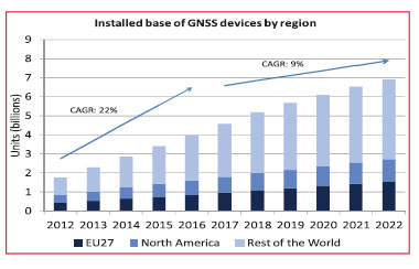
On the 15th of October 2013 the European GNSS Agency (GSA) released the latest version of its GNSS Market Report. The Market Report brings an updated and enhanced view of the GNSS global market “as it is experimenting rapid developments”. It encompasses a larger scope than before

The main focus of this paper is the spectral and spatial characterization of GNSS jammers with specific emphasis on multi-frequency wideband jammers which are able to simultaneously jam up to three frequencies. The paper extends previous analysis to jammers also operating in the L2 and L5 bands


 (5.00 out of 5)