| GNSS - New | |
Comparative analysis of online GNSS processing websites on selected geodetic control stations in Oyo town, Nigeria
The results obtained from differential GNSS observation and online processing websites were compared and analysed to determine their accuracy levels with applications areas |
 |
|
 |
|
 |
|
 |
|
 |
|
Availability of Ground Control Points for surveying and engineering projects is a major challenge in developing countries including Nigeria. Reliable control stations are either several kilometres from project sites or not available in some cases. Surveying and mapping projects are carried out with GNSS receivers in differential mode with at least two receivers and the data processed with proprietary software from GNSS equipment manufacturers which make project cost too expensive for clients. Continuously Operating Reference Stations (CORS) in developing countries is an alternative to passive ground control stations but CORS users face some challenges such as data not available when needed, difficulty in accessing the data, lack of understanding in processing field observations with CORS data together. This study was undertaken to assess the accuracy levels of some selected free Online GNSS Processing Websites for the establishment of ground control stations. Methodology included establishment of second order control stations using GNSS receivers and uploading the field data to selected Online processing websites. The results obtained from differential GNSS observation and online processing websites were compared and analysed to determine their accuracy levels with applications areas. Recommendations included creating awareness among surveyors and other professionals on the functionality, reliability and dependability of online GNSS processing websites so that users can fully explore the potential of the online facilities in mapping and possibly cadastral applications in Nigeria and other parts of the world.
Introduction
Many applications in physical planning and scientific studies require geospatial data from field measurements. The field survey measurements will only become useful when processed with reliable Ground Control Points (GCPs). Global Navigation Satellite System (GNSS) is the modern method for establishment of ground control points and for easy navigation and positioning. Components of GNSS include the US Global Positioning System, Russian GLONASS, European Union Galileo and Chinese Beidou. Control surveys establish precise horizontal and vertical positions of reference monuments, there are two general types of control surveys namely horizontal and vertical controls (Ghilani & Wolf, 2012). Horizontal control surveys generally establish geodetic latitudes and longitudes of stations over large areas. From these values, plane rectangular coordinates, usually in a state plane or Universal Transverse Mercator (UTM) coordinate system can be computed. Vertical control surveys establish elevations for a network of reference monuments called benchmarks. Depending on accuracy requirements, they have traditionally been run by either differential levelling or trigonometric levelling. GNSS survey can also establish vertical control but are limited by the need for a precise geoid model. Network of ground control points serve as the basis for originating or checking subordinate surveys such as topographic and hydrographic mapping; property boundary delineation; and route and construction planning, design, and layout. They are also essential as a reference framework for giving locations of data entered into Land Information System (LIS) and Geographic Information System (GIS).
GNSS has been used extensively by surveyors primarily for geodetic control networks and for photo control. The system has become more compact, more technologically advanced, easier to use and with a full complement of satellites enabling 24-hour usage, the diversity of surveying applications has increased significantly. GNSS systems are now available for many surveying and mapping tasks, including establishing control, setting out, real-time deformation monitoring, on-board camera positioning for aerial photography and the list is continually growing. GNSS is a tool for fixing positions, navigation and timing. GNSS receivers range from low-cost systems with a positional accuracy of tens of meters, to high-cost geodetic survey systems able to determine positions to the centimetre and millimetre level. For survey accuracies, it is essential that hardware and software specifically designed for survey applications are used and these should always be utilized in the manner for which they were designed.
Positioning modes in GNSS can be absolute positioning or relative positioning. Absolute positioning involves Precise Point Positioning (PPP) which is a positioning technique that removes or models GNSS system errors to provide a high level of position accuracy from a single receiver without any base station. Relative positioning is called differential positioning which employs two or more GNSS receivers simultaneously tracking the same satellite to determine their relative coordinates. The requirement for relative positioning is that at least one station should be selected as base station.
International GNSS Service (IGS) maintains open access and free highquality GNSS data and products for scientific, educational and commercial applications (www.igs.org/about). The products are contributed from more than 100 countries and by over 200 selffunding agencies, universities and research institutions. The IGS operates a global network of GNSS ground stations, data centres and data analysis centres to provide data and other derived data products for earth science research, positioning, navigation and timing applications. GNSS data Analysis centres attempt to estimate inter-system calibration biases, compare equipment performance and further develop processing software capable of handling multiple GNSS observation data. The IGS Real-Time Service (RTS) is a GNSS orbit and clock correction service that enables Precise Point Positioning (PPP) at worldwide scales. The RTS products enable applications such as scientific testing, geophysical monitoring, hazard detection and warning, weather forecasting, time synchronization, GNSS constellation monitoring, imagery control and many other public-benefit applications (Agrotis et al., 2012). Surveyors, GIS analysts, engineers, scientists, and the public at large that collect GNSS data and use CORS data to improve the precision of their positions.
Regarding the improvements in GNSS data processing methodology, many new opportunities have been offered to the users. Several software packages to process precise GPS/GNSS data for research applications have been developed by different international research groups. The availability of executable code, documentation, and user support varies with the individual development group. Recently, web based GNSS positioning services have begun to be developed as an additional option to classical evaluation methods. Such services produce solutions automatically by using some of the GNSSS observations loaded via the web interface over the Internet. GNSS observations collected in the field are recorded in standard data formats such as Receiver INdependent EXchange (RINEX) and then uploaded to web-based positioning services, allowing location coordinates of observation points to be obtained in short time and free of charge (Ulukavak,2018). Many organizations have developed online GNSS processing services. These services provide GNSS processing results to the user free of charge and with unlimited access. The user sends a Receiver Independent Exchange Format (RINEX) file to the service and within a short period of time, the estimated position of the receiver used to collect the RINEX data is sent back to the user.
The only requirement for using these services is a computer having an internet connection and web browser. These services are designed to be as simple as possible for the user and with minimal input. Some of these services process not only the GPS but also the data of other systems, particularly those of GLONASS, and provide resilience and a higher accurate positioning service in certain cases to their users (Isioye et. al., 2019). Web-based positioning services have been considered as an alternative to scientific or commercial software for years. These services provide many advantages to users by reducing the cost of software, hardware, tools, personnel and transportation services.
The results of GNSS observations uploaded to these services provide many advantages such as the possibility of downloading results from the web interface or sending the results to the users via e-mail. Many of these services are free and some of them require free membership for accessing with a username and password while using (Ulukavak, 2018). In general, these services use the data and products of the high accurate and precise International GNSS Service (IGS).
Problem definition
Getting reliable Ground Control Points (GCPs) for surveying and mapping projects is a major challenge in developing countries including Nigeria. Data from the existing Continuously Operating Reference Stations (CORS) is either not accessible or not available to users. Control establishment and mapping projects with GNSS receivers are carried out in differential mode with the use of at least two receivers. The receivers are expensive and the post processing software is costly. The existence of online GNSS processing services has provided alternative solution to this challenge. It is also necessary to evaluate the accuracy levels of these online processing centres and guide users on their application areas.
This study was aimed to carry out comparative analysis of online processing service centres and provide the accuracy levels of coordinates derived from the centres using different processing techniques.
The objectives set to achieve the aim of the study included project planning, selection and monumentation of observation points, GNSS data acquisition, processing and analysis of results.
Study area
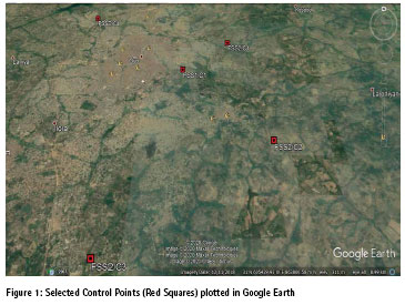
The project site is Oyo town in Oyo State, Nigeria. Oyo town covers approximately an area of 28,454 square kilometres and it is located on latitude 7.8430oN and Longitude 3.9368oE. The selected stations for monumentation are located in the following areas:
i. Emmanuel Alayande college of Education main gate at Erelu, Oyo West Local Government Area.
ii. Bode Thomas High School along Oyo / Ogbomosho road, Atiba Local Government Area
iii. Along Awe / Iwo road, Afijio Local Government Area, Oyo.
iv. Federal College of Education (Special) main gate, Afijio Local Government area,
v. Federal School of Surveying, Oyo East Local Government Area
The selected points were beaconed with concrete pillars of cement, gravel and sand mixed in the proportion of 1:2:3 (one portion of sand, two portions of gravel and three portions of sand) of dimension 20cm x 20cm x 100cm.
Online GNSS service centres used
The study used the following online services:
i. Online Processing User Service (OPUS): This is operated by the US National Geodetic Survey (NGS). Users can upload dualfrequency GPS data collected with a survey-grade receiver in static mode. The centre can process the data either as static or rapidstatic modes depending on the data span. Observation files under two (2) hours are processed as rapid-static whereas files between 2hrs. and 48 hrs. are processed as static. OPUS utilizes relative positioning for positioning with respect to three nearby CORS stations. The solution will be sent via the e-mail provided by the user within few minutes.
ii. MAGIC GNSS: The free online multi-constellation GNSS PPP service was developed by the Spanish GMV Aerospace and Defense Company, in 2008. This service supports not only GPS but also other GNSS satellites. Users can send the dual-frequency observation files via the service’s web site or e-mail. The PPPderived coordinates can be estimated in static or kinematic modes. The magicGNSS provides three different levels of usage as: a post processing service (for registered users), e-mail service (free) and real-time service. The results including coordinates and the reports are sent back to the users through e-mail.
iii. Canadian Spatial Reference System – Precise Point Positioning (CSRS-PPP): The service has been operated by Natural Resources Canada, Canadian Geodetic Survey since 2003. The online post-processing PPP service is free and users submit GNSS data to the service via web page with a valid e-mail address to which the processed results will be sent. It accepts single or dualfrequency data from GPS and GLONASS satellites by using the best available ephemerides (final, rapid or ultra-rapid), and can process the data approximately 90 minutes after data collection.
iv. Automatic Precise Positioning Service (APPS): The service is operated by NASA Jet Propulsion Laboratory, California Institute of Technology. User can send their observation files via web site, e-mail or service’s ftp site. The PPP-based service provides static and kinematic processing modes by using JPL’s GPS orbit and clock products.
v. AUSPOS-Online GPS Processing Service: This free online service provided by Geoscience Australia accepts only dualfrequency geodetic quality GPS data observed in static mode for more than 1-hour data span (preferably 2-hour). The service does not process kinematic data and other GNSS data. The data can be sent to the service through the web site or using ftp site. It utilizes a relative method for positioning by establishing a network consisting of the nearest 15 IGS stations using the best available IGS products. The result in Adobe PDF format Australia accepts only dualfrequency geodetic quality GPS data observed in static mode for more than 1-hour data span (preferably 2-hour). The service does not process kinematic data and other GNSS data. The data can be sent to the service through the web site or using ftp site. It utilizes a relative method for positioning by establishing a network consisting of the nearest 15 IGS stations using the best available IGS products. The result in Adobe PDF format includes station coordinates computed in ITRF2014 and other information will be e-mailed to the user when the processing is completed within few minutes.
vi. Trimble CenterPoint RTX (Real Time Extended): The free service operated by Trimble provides a cm-level of accuracy for positioning globally using dualfrequency data collected in static sessions for at least 60 minutes. The service is now available for other satellites (GLONASS, Galileo, BeiDou and QZSS).
Methodology
This involved the procedure and techniques adopted for the establishment of horizontal and vertical positions for the new control stations using GNSS positioning technique. GNSS receivers were properly selected and configured for the field observation. Two ground control stations established with Nignet (Nigerian Network of CORS) within the Federal School of Surveying campus were used as base stations to coordinate other newly established stations and observations lasted for two hours on each station occupied by GNSS receiver. During the observations, height of instrument was properly measured with tape and recorded.
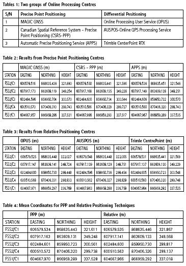
The field observed data was downloaded and processed to obtained coordinates (X, Y and Z) of stations occupied. The downloaded data was first processed with proprietary software and uploaded to GNSS online processing centres for further analysis and more refined results. The processing methods can be grouped into two namely absolute (Precise Point Positioning) and relative (Differential) processing methods (Table 1).
The coordinates obtained from online services were projected to Universal Transverse Mercator (UTM) in Zone 31N using WGS 1984 as reference ellipsoid as shown in Table 2 and Table 2.
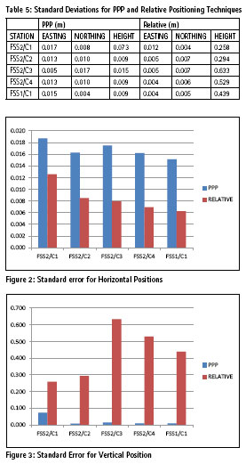
Table 5 shows standard deviations of the eastings, northings and heights obtained Online processing centres, standard deviation is a measure of the amount of dispersion of a set of values. A low standard deviation is an indication that the values tend to be close to the mean while a high standard deviation indicates that the values spread out over a wider range.
Ranges of standard deviations for the two positioning techniques as computed from Table 5 are:
a PPP technique
Easting Coordinates = 0.017 – 0.005 = 0.012m
Northing Coordinates = 0.017 – 0.004 = 0.013m
Heights = 0.073 – 0.009 = 0.064m
b Relative positioning technique
Easting Coordinates = 0.012 – 0.004 = 0.008m
Northing Coordinates = 0.007 – 0.004 = 0.003m
Heights = 0.633 – 0.258 = 0.375m
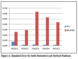
Examining the standard deviations in Table 5 and Figure 2, it is obvious that relative positioning techniques are more precise for horizontal positions. For height, Precise Point Positioning (PPP) gives more precise results and it can be recommended that if users intend to establish control points in both horizontal and vertical positions, PPP is more preferable (Figure 3 and Figure 4).
Conclusion and recommendations
A comparative analysis of some online GNSS processing services for the establishment of ground control stations has been made. It was discovered that online GNSS processing services are reliable for users using either precise point positioning or relative positioning techniques. However, projects requiring high accuracy in vertical position or both horizontal and vertical position should adopt Precise Point Positioning techniques. Other factors influencing accuracy achieved include observation period which should not be less than 2 hours, height of instrument which should be measured accurately and setting the instruments away from objects causing multipath effects. The following are recommended: i. Online GNSS data processing centres can be adopted for control establishment for surveying, mapping and engineering projects and GIS data collection
ii. To obtain high degree of accuracy, dual frequency GNSS receivers should be used in static survey method and observation should not be less than two hours
iii. There should be awareness among surveyors and other professionals on the functionality, reliability and dependability of online GNSS processing websites so that users can fully explore the potential of the online facilities in mapping and possibly cadastral applications in Nigeria and other parts of the world.
References
AUSPOS – Online GPS Processing Service: https://www.ga.gov. au/scientific-topics/positioningnavigation/ geodesy/auspos
Canadian Spatial Reference System (CSRS): https://www.nrcan.gc.ca/ maps-tools-publications/tools/geodetic-reference-systemstools/ canadian-spatial-referencesystem- csrs/9052#csrs
Ghilani, C. D. & Wolf P. R. (2012). Elementary Surveying: An Introduction to Geomatics 13th ed., Upper Saddle River, New Jersey Pearson Education, Inc., pp.331-397
International GNSS Service (IGS): The IGS at a Glance. http:// www.igs.org/about (Accessed on 15th January, 2020)
Isioye, O. A., Moses, M. & Abdulmumin, L. (2019). Comparative Study of Some Online GNSS Post-Processing Services at Selected Permanent GNSS Sites in Nigeria. http://dx.doi. org/10.5772/intechopen.79924
MAGIC GNSS: https:// magicgnss.gmv.com/# (Accessed on 17th January, 2020)
Online Positioning User Service (OPUS): What is OPUS? https:// www.ngs.noaa.gov/OPUS/about.jsp (Accessed on 17th January, 2020)
(Accessed on 15th January, 2020)
The Automatic Precise Positioning Service (APPS): http://apps.gdgps.net/
Ulukavak, M. (2012). Evaluation of GNSS Data with Internet Based Services: The Case of HRUH Station (pp. 73-74). http://dx.doi. org/10.5772/intechopen.79064


 (No Ratings Yet)


Leave your response!