| SDI | |
User requirements analysis for the development of NSDI
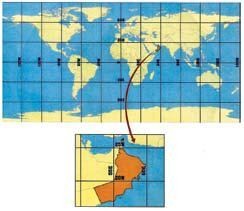
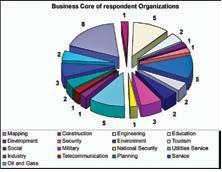
The economic and social development in the Sultanate of Oman during and after 1970 became the basis of assessment and planning to identify priorities of national development. For this, the role of geographic data to support sound decisionmaking has been considered important to support development programmes. Thus, the framework of dataset or the fundamental data in the Sultanate needs to clearly identify what constitutes the basic data used and produced by the government and private institutions. In Oman, there have been discussions and interactions for last many years to enrich this aspect with achievements. Still, there is no consensus in views or whatsoever about framework datasets which would give importance to the geographical datasets to be as value to the government agencies and to private sector companies to achieve their needs. To run an NSDI, the critical points considered to be must are – to have the proper identification of datasets which have different national importance; activation of specific standards; and identification of priorities and commitments among the organizations working in the field of GIS. Therefore, the common datasets for the Sultanate are those data which are used with great popularity by the various members of the GIS community to meet their various needs. Certainly, there is a need to identify the datasets required by the widespread users and also a need to find out whether these datasets meet the expectations of those who use them. There is also a need to know the productive enterprises and the extent of duplication with others. With these objectives, this study is structured to clarify these aspects, identify and prioritize the framework datasets through the study elements that is embedded with questionnaire, interview and review of the data valuable in order to identify the fundamental data to represent the foundation stone for a wide range of activities and applications. To reach the goal by determining the specific aspects of the datasets available in the Sultanate, which is seen as more applicable for large segment of users and help in the discovery of any framework datasets, priority should be given to this integration in Oman NSDI. Sultanate of Oman at a glanceThe Sultanate of Oman occupies the south-eastern tip of the Arabian Peninsula between latitude 16° 40´ and 26° 20´ northand longitudes 51° 50´ and 59° 40´ east. It is bordered to the west by the United Arab Emirates and the Kingdom of Saudi Arabia and the South by the Republic of Yemen, the Strait of Hormuze to the North and Arabian Sea to the East. Spatial data evaluation methodsOne of the fundamental starting points for developing NSDI in the Sultanate is to clearly understand, identify and describe the user requirement. The study explores, develops and evaluates specific spatial data which will be suitable to be the core of NSDI dataset. Questionnaire, interview and data review are the important elements of this study. These elements give a clear picture about the situation of spatial data activities of the Sultanate of Oman. The study elements are targeted to GIS organisations in all development sectors in the Sultanate, whether they are producers or users of the geo-spatial data. The business core of these organisations, as illustrated in figure 2 indicates that the mapping sector leads due to its significant impact on geospatial data production in the Sultanate by eight institutions, followed by engineering sector, environment and utilities services by three institutions for each. The third happens to be the military and services followed by the rest of other sectors. The main message coming out of these organisations is that there are diverse opinions about NSDI and types of fundamental geospatial datasets. However, there is a general agreement on essentiality to adopt the government NSDI technology. Questionnaire contentsThe questionnaire has been designed carefully to cover all the study aspects. It is conducted in four parts in quantitative manner as mentioned below: • Part A: Awareness of the existence and benefits of National Spatial Data Infrastructure (NSDI). • Part C: Availability, accessibility, applicability and usability of data
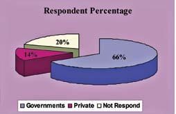
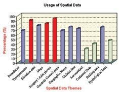
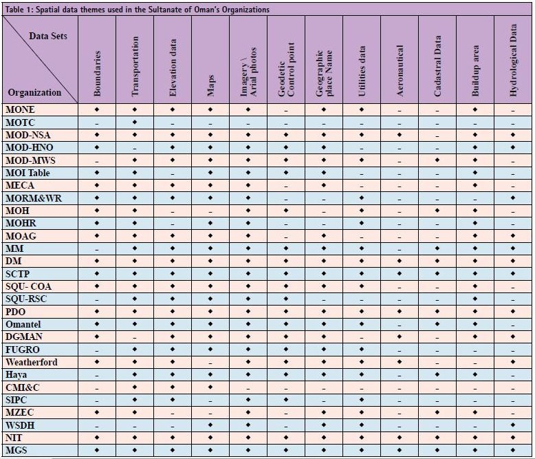
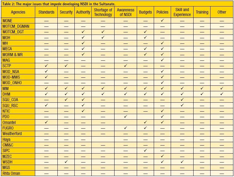
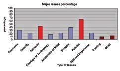
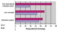
Figure 4: Percentage of used spatial data in the Sultanate according to the questionnaire outcome. Questionnaire respondentsThe intention of this survey was to incorporate views from users in different sectors. The questionnaire was distributed to 35 organizations working in the field of GIS including government and private sectors. 28 organizations responded the feedback questionnaire. The respondent percentages from government department and private sectors are illustrated in Figure 3. Spatial data usageThe information of spatial data usage which brought by the questionnaire was analysed. The findings are mentioned in table 1 and figure 4. The outcome of the analysis indicates spatial data interests i.e. images / aerial photo, transportation data and maps constitute around 80%. Geographic place names, build up area and elevation data come second with almost 70%. Utilities, geodetic control points and administrative boundaries also have relatively high percentage of usage at 60% level. The less percentage usages, below 42%, are hydrological data, cadastral and aeronautical information which apparently interested to a few agencies. Fundamental datasetsThe user need assessment as resulted from this study suggested the fundamental datasets for the Sultanate of Oman. This data is a group of basic information for the data that can not be derived from other information, which represent the phenomena as location, objects, or important subjects to understand the environmental, social benefits and economic levels of regional and subnational and local communities. Taking into account the essential needs users from different sectors and the relevant technical specifications such as the quality, continuity and accuracy. On basis of the definition and the criteria mentioned above, the fundamental datasets for the Sultanate of Oman have been chosen as following: • Transportation • Boundaries information • Geodetic Control Network • Utilities and services • Imagery \ Arial photos • Elevation data • Maps • Cadastral data • Hydrography • Geographic place names • Aeronautical data Issues impeding NSDI developmentSeveral issues have been highlighted according to organizations perspective, which considered impeding the NSDI development. Table 2 and figure 5 indicate that more than 65 % of the respondents have chosen policies as the major issue impeding the NSDI development. Authorization and budgets come second (42%) and third (40%) correspondingly. 30-19 % of the respondents consider standards, security, shortage of technology, awareness of NSDI and skill of experience as issues that are affecting the development of the NSDI. The less aspectual types are training which come less than 10% of the total 23 responses while 5 responses have been excluded due to lack of information. Metadata circulationThe current situation on the production and circulation of metadata information needs to be evaluated in the coming years. Although the results of the survey indicate there is growing interest by creating metadata by almost half of the respondents, the largest percentage (57%) of firms do not own or have traded metadata while (70%) from the rest whom have metadata do not use and follow international well known standards. This finding reflects negatively on the integration of geographical data and therefore will not bring the principles of participation. The questionnaire also indicated that there is a positive sign that the majority of the respondents who don’t use metadata realize the importance of such data and that they are in interested in activating it in the near future. Figure 5: Illustrates the major issues percentage Standards usageStandards are one of the foundations upon which the NSDI can be built and a mainstay in the integration of geographic data in order to achieve subscription principle among the members. Figure 6 illustrates the majority of respondents up to (62%) using the standards that correspond with their requirements and meet their needs. This certainly reflects the quality of the product, but to achieve the benefits of standards among the members, it must serve the purpose of integration and data exchange. The result, unfortunately, is disappointing. The study has shown that only 35% of users have used uniform standards while the rest are using their own standards. Furthermore, more than 65% of the organisations do not have any membership or linkages, whether internal or external standards organisations. The weak linkage between institutions and absence of a body or centre that concern the standards application between the institutions of the Sultanate can be the reason for such an outcome. Figure 6: Represents the metadata activist between respondents Accessibility and applicability of geospatial data
Distribution, participation and existence of agreements for the integration and data exchange are the main problems being faced by the geo-spatial activities in Oman. It is clear that the majority (75%) of the institutions are facing problems in achieving the subscription (figure 8), and this is due to the many reasons such as the maturity of government initiatives to provide comprehensive with accuracy and calibration required, and understanding the nature of geographical data in terms of specifications compatible with the integration and multi-use. For this, reliance on individual initiative and individual use is prominent in more than (50%) of the institutions included in the study which suggests the need for halting the flow of funds and the depletion of the effort to achieve the objectives of individual limited. ConclusionThe paper elaborates the geospatial data situation in the Sultanate of Oman by reviewing questionnaire results. The fundamental geospatial data which uses mostly in government and private institutions was specified to be the backbone of Oman NSDI. The paper also explains the most important points concerning the nature and accuracy of these data, and the availability of the user’s needs which are compatible with sustainable development in the Sultanate. The results indicate there are many issues concerning geo spatial data in the Sultanate that need to be evaluated and resolved before initiating the NSDI. The issues being considered as most important obstacles facing the establishment NSDI are essential development of standards for data acquisitions and all producers must comply them for data integration. In addition, the associated legislation to coordinate the participation and finding executants for data access whether individually or collectively is also required. On metadata use, the study shows clearly that producers interest does not exceed third of the institutions included in the study while the double of this percentage do not use geographic data standards. For this, the integration of these data among themselves for many applications most certainly is another obstacle that affects data sharing and distribution. ReferenceMinistry of Development (MD, 1996) Socio-Economic Atlas , Information and Documentation Centre, November 1996, page 2-4.
|



 (50 votes, average: 1.00 out of 5)


The OGC has just completed a global survey on the business value of open standards with several hundred respondents from around the world. It seems that some education and awareness is required in Oman around the value of standards.
The OGC is building the linkages described in this article with a number of organisations in Abu Dhabi, Bahrain and Dubai – Oman, Qatar, Saudi and other countries from the region should also be involved.
I am willing to provide some input on the standards usage aspect based on my role at the OGC, and also my role at the GSDI Association. Feel free to contact me sramage@opengeospatial.org
Leave your response!