| Application - New | |
The land reforms in the Democratic Republic of Congo
Practical solutions for the protection of smallholder land rights |
 |
|
 |
|
Abstract
In the East of the Democratic Republic of Congo (DRC), insecurity of tenure rights, displacement, poverty and general security issues are major obstacles to economic and social development and a transition to a more peaceful and prosperous society. Congolese land reforms are part of a process to promote the country to the status of emerging economy by 2030 and industrialized country by 2050. Reforms that promote and protect the rights of vulnerable farmers and contribute to these objectives require pragmatic and effective solutions. This paper presents such a practical solution to the insecurity of occupation and land use in the east of the Democratic Republic of Congo, where people in most cases access and govern land via customary systems. The presented case describes the efforts around improving tenure security of a consortium that is working to contribute to peace building through a large-scale irrigation project called Maji Ya Amani – Water for peace.
Introduction
In the East of the Democratic Republic of Congo (DRC), insecurity of tenure rights, displacement, poverty and general security issues are major obstacles to economic and social development and a transition to a more peaceful and prosperous society (see: Betge 2019). Persisting tensions between legal and customary land governance systems, which also occur in many other countries in sub-Saharan Africa, are increasing the complexity of the situation and in particular the challenges facing smallholder farmers (see also: Knight 2010).
In much of sub-Saharan Africa, the colonial land policies used customary law and land tenure as instruments, inviting colonial governments to justify the dispossession of the local population while serving local communities as an (apparent) tool to protect themselves against new land losses (Peters 2013). Since the colonial times, African governments have repeatedly tried to reorganize their land tenure systems. Extensive land titling programs were initiated in the 1960s and 1970s by the newly independent countries (ibid.). These aimed at transforming customary forms of land ownership to create a modern land market and strengthen the security of land rights. Most of these programs did not lead to increased investment and productivity, but have strengthened the patterns of unequal access to land and increased conflicts around land (ibid.). However, it is clear that customary tenure systems can similarly create high inequalities, highly exclusive property systems and, in many cases, have not been able to prevent the alienation of land through large-scale external investment with very negative effects for the poor.
In recent years, land tenure reforms have generated renewed interest and various African governments have developed new land policies (Cotula et al 2004). Land policies and reforms are meant to be used as pro-poor land tools for more transparent and accountable land administration (Peters 2013).
At the same time, they are supposed to respond to economic growth and development. The DRC government has engaged in a broad process of land reform in the current decade, with different phases of progress and stagnation (Koné et al 2016). Congolese land reforms are part of a process to promote the country to the status of emerging economy by 2030 and industrialized country by 2050 (CONAREF 2018).
In November 2018, an interprovincial workshop was held in Bukavu to draft a national land policy for the Democratic Republic of Congo where basic aspects were agreed upon, among which:
• The need to revise the land law of 1973;
• Securing and registering user rights and use of technological innovations;
• Greater mobilization of land for economic growth and poverty reduction;
• Development of more effective and efficient land administration systems;
• Guarantee of access to land in line with the interests of the majority of the population.
Recently, a consultation process was launched in different provinces of the DRC to gather feedback on the first draft of the national land policy document (see: conaref-rdc.org). At a Conference on Lands and Conflict in Eastern DRC, held in Bukavu in June 2019, various practical options for improving the land rights situation in the Democratic Republic of Congo were discussed by a broad range of stakeholders including local governments, customary chiefs, national government, NGOs and international partners. A central point of discussion was the fragility of informal and customary land ownership, particularly in conflict-affected areas.
The formalization (titling) of customarily owned land poses its own problems and may even exacerbate conflicts. However, the previous significant acquisitions of customary land (see for example Peters 2013) and ongoing violent conflicts around land in areas where land governance is mainly customary, as well as frequent dispossessions of customary landowners in the DRC (see for example Vlassenroth nd) clearly require practical and effective solutions to the prevailing insecurity of land tenure.
This paper presents such a practical solution to the insecurity of tenure in the east of the Democratic Republic of Congo, where people mainly access and govern land via customary systems. The context, process, prospects and potential traps of the solution are discussed in detail, based on the experience of a consortium-led integrated water resources management project. As part of this project, a system for the allocation of grouped titles was tested as the most practical way to protect existing land rights in an environment highly affected by the conflict.
Case context
The presented case describes the efforts of the Dutch International NGO ZOA in a consortium that is trying to contribute to peacebuilding through a large-scale irrigation project called Maji Ya Amani – Water for peace. The project is set in the border region of the DRC with Burundi and Rwanda in the Ruzizi plain. In this context, land rights are a particular concern because in the area, different communities have a history of conflict over land issues, notably due to repeated clashes between pastoralists and farmers, as well as broader issues of political and economic power. In addition, the sharp increase in land value that will be achieved through irrigation of about 1035 hectares of land in the plain will be a potential source of conflict, especially if outside actors are interested in taking advantage of it. From the beginning, it was understood that improving the land through irrigation would result in an increase in land value and potential speculation, jeopardizing those who currently occupy and use the land (see Betge et al 2019. In the project area, most of the land rights are rooted in customary systems that are strained due to ethnic tensions, migratory pressure, and violent conflict. The land related problems in the area are exacerbated by the influx of new residents, the shrinking of available fertile land (due to demographic and climatic reasons), land sales organized by chiefs without the knowledge of the smallholders, and co-operatives that are well organized but whose boundaries are not always clear (ibid.). Routes to cattle watering holes have been altered as water becomes more scarce, while other routes have been appropriated by small farmers in need of land (ibid.).
In order to prevent the local population from losing access and ownership of land, an overview of current patterns of land use and ownership was needed, on the basis of which existing rights could be guaranteed.
ZOA facilitated an extensive participatory mapping exercise supported by the Cadasta Foundation and using the Cadasta platform for data storage. This demarcation, based on the principles of the Social Tenure Domain Model (STDM), has provided a platform for reaching consensus among the different actors involved at all levels and including traditional authorities, different organizations and civil society, local and provincial authorities, land administration (cadastre & CTI), technical services (agriculture and rural development) and each affected landowner.
The fundamental legislation regulating land rights in RDC includes law no. 73- 021 of 20th July 1973 on the general property, land, and real estate and the regime of security interests (so- called Bakajika Law). This text and its decrees of application function as the Land Tenure Code (Betge et al 2019).
Process
To mitigate the risk of conflict, ZOA and Cadasta Foundation facilitated a broad participatory mapping exercise together with the government, the customary authorities, and local communities to map and document land rights and the irrigation infrastructure across an initially estimated 5,000 parcels (Betge et al 2019). Including the land administration authorities in this process was key to enable the preparation for recognition of land rights and to ensure process ownership by the state.
Despite the long-standing rivalries and history of violence in the area, key traditional leaders agreed to support the project following their involvement in the participatory mapping exercise (Betge et al 2019). Provincial authorities have also given guarantees that the current access and land use arrangements will be protected and the participatory demarcation was conducted with the active involvement of the communities, local land bureaus, and technical experts trained by Cadasta. ZOA’s partners are simultaneously working on the establishment of land management councils and other supportive measures. They actively engage the broader community in awareness raising campaigns and the drawing up of by-laws for land management to prepare for the re-established irrigation infrastructure.
The graph (figure 1) gives an overview of the participatory mapping process that eventually led to the legal solution for securing tenure described below.
The “Consolidated Title” as a method of land tenure security adopted by the stakeholders, notes the co-ownership between the occupants in the irrigated area of Luberizi to protect the land rights of family farmers. For any co-owner of a land title in the irrigated area of Luberizi, the individual land right is recorded in an individual file issued from the participatory mapping. This individual file shows the picture of the owner, his/her family and relatives who can inherit the land in case the owner passes away and is attached to each group title to establish the extent of the rights of the members of the co-ownership. The plots are grouped according to legal standards in the DRC to be the object of the grouped securitization in order to secure the irrigated area of Luberizi, and improve the land security and access to land of the population.
The group titling of land is a special regime to protect the collective interest of the farmers and ensure the sustainability of the family farm, in accordance with Congolese Law. Given the initial situation of the occupants, including the challenges related to the exorbitant cost per individual title and contextual factors (impossibility to facilitate the creation of a special zone in Luberizi to protect specific local rights), it was agreed, with all the operators to secure their lands in the area through the grouped titles.
The graph (figure 2) provides an overview of the different steps followed until the issuing of the group titles.
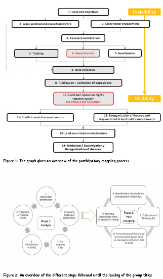
In the graph (figure 2), it can be seen that the whole process took place in nine steps divided into two phases (analysis of the existing plots through participatory mapping and post mapping operations). During these stages, there was a direct and active implication of the members of the community, local, territorial, provincial and national authorities, it is important to highlight that the technical part of the work was done by specialized technicians from both the government technical services and project technicians in collaboration with Cadasta (https:// cadasta.org/). At the beginning of this process, it was a question of obtaining the commitment of the different stakeholders through identification and mobilization and memorandum of understanding to support the process was signed.
Subsequently, six teams, each made up of four people (a representative of the local land administration, a representative of the community, a social facilitator and a cartographer) were trained on the “CADASTA” technology. CADASTA technology was created in 2015 to allow individuals, organizations, communities and governments to collect precise information related to land tenure and natural resource management. It makes it possible to analyze, save and share real data on any given land with a precision of approximately 30 cm.They were also trained on how to use electronic equipment (developing an ODK Collect form, using smartphones and Trimble catalyst antennas) and participatory mapping techniques.
Before the participatory mapping, thanks to the support of community leaders, the owners of the plots in the perimeter were identified, sensitized, mobilized and made aware of the importance of this approach to securing land using “CADASTA”. During this stage, the roles and responsibilities of each member of the team and the planning of activities for the participatory mapping were defined. The participatory mapping activities took place in two stages. (i) Field work in which information such as the dimensions of the plots/boundaries, identities and relatives of the owner of each plot were collected electronically and manually. (ii) The second step was to download the information from the smartphones to the server (Cadasta platform) and thus recover them via QGIS in order to develop the sketches (croquis) of the plots.
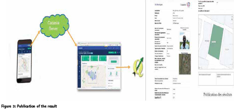
The publication of the results consisted of printing out all the information and were made public in each village to make sure that any complaints, disputes, possible errors and conflicts have been identified and referred to specialized structures for mediation and conflict resolution. This is a crucial stage as in this model no group title can be delivered if not all the conflicts have been resolved. The process proved highly complex as different stakeholders needed to be involved in all the steps: government authorities, local authorities, land administration officers, famers and civil society organisations; to resolve the conflicts before issuing the group titles.
The group titling model was assumed to be the best available option for the following reasons:
• It reconciles legality and the legitimacy, through the participatory process;
• It increased the social cohesion among the population of this area;
• The group titles allowes poor farmers to have access to credit and to be able to invest in agricultural activities;
• Moreover it prevents potential land grabbers to easily acquire land from the poor famers.
Securing rural land in a conflict-affected area is an important and delicate issue that requires special attention from interveners and broad stakeholder participation. In addition, with regard to the land of local communities and indigenous (specifically Pygmy/Batwa) peoples, the 1973 Act created uncertainty about their exact status and insecurity with regard to the rights of users by providing that usufruct rights acquired according to custom, would be settled by an order of the President of the Republic. This order has never been signed to date.
Given the extent of land conflicts in all territorial entities of the South Kivu Province, resulting among others from the multiplicity of practices that are considered outside the law, and taking into account the process of land reform launched by the Government of the Democratic Republic since July 2012, a custom-based decentralized land management system in South Kivu Province is needed to secure the rights of customary land users while protecting them from arbitrariness.
Risks and risk mitigation
There are certain risks to the chosen approach relating to four broader categories: social, political, power-related, and economic. Social risks mainly relate to the peaceful cohabitation among the people sharing the same group title as they are from different ethnic backgrounds and communities in the area. Political risks relate to the lack of good governance in DRC and the potential that in due time a different (land) governance regime may come up with new laws altering and potentially complicating access to land. Economic risks are also related to the relations among people sharing the same title. For example, in case they agree to apply for credit as a group and some of the group members do not adhere to the credit rules, banks and other finance institutions might have to stop providing credit service to the group as a whole. Abuse of power by power holders remains the most incalculable and most difficult to mitigate risk. Generally, in order to mitigate the identified risks, the occupants need to remain social coherence and continue to cooperate to safeguard the acquired social peace and to boost the local development. The external interveners need to do their utmost to support this process, fulfilling the different and complementary roles established by the consortium. This requires e.g. the setting up and accompaniment of land management committees, structures for increased community cohesion, continuous monitoring of social developments by the consortium partners and flexibility in programming based on feedback from the communities.
Arguably, in order to mitigate the risks in a sustainable way, it is believed that the basic act (acte de base) as a supporting document of each grouped title is a key element. This basic act is a legaladministrative document governing all rights and duties between persons grouped in a title. This allows the co-owners to determine who will keep the common title, the person who will represent the others at financial institutions, in case they request a credit “input”, etc. In addition to this basic act, the co-owners define how the succession will be made in case of sale of part or all of the individual plot of a co-owner, but also who bears the costs related to the transfer of rights. Likewise, the procedure on how conflicts arising in the group will be managed internally and their possible referencing to higher levels for dispute resolution will be detailed in this document to prevent and manage any disputes.
Discussion
As described above, the land governance system in the DR Congo is changing in response to urgent challenges related to land tenure security and conflicts that are exacerbated by or even rooted in land questions. At the same time, the authorities in DRC are struggling to provide good governance and administrative services on all levels and the ongoing conflicts in the eastern part of the country frequently disrupt attempts to improve service delivery and governance.
In this context and without a clear indication when new land laws will be adopted and implemented, different types of interveners who aim to contribute to conflict reduction and social and economic development in the country need to find practical solutions to land related challenges that hinder progress in other domains.
Both customary and state systems are challenged either by lacking legitimacy or lacking legality, in some cases both. This requires finding solutions that can address these challenges as well as possible. In the context of ongoing reform processes and violent conflicts, such solutions will always be imperfect and likely require trade-offs. However, the approach described in this paper has to date proven to enable a cooperative mode of progressing with a programme that has the potential to significantly improve the economic opportunities and the social cohesion and stability of one highly fragile area. The development of this approach required adaptive programming, time and resources committed by the different stakeholders, including the donor, and a healthy dose of pragmatism. Despite these requirements, the approach appears a promising option for other areas of the DRC that experience similar challenges.
Conclusion
Group titling presents a challenging but highly interesting option in the context of the Congolese land reform process. The model can provide a solution when it comes to securing the land of poor rural famers who cannot pay for an individual title due to its immense costs but whose tenure security is permanently threatened because of a lack of formal recognition and social and political stability.
The group title can contribute to economic development is serves as a guarantee to financial institutions while tenure security allows for land investments.
Furthermore, the group title supports processes to increase social cohesion among the co-owners as they set rules on how and where to keep their common titles and collaboration. Positive impact has been observed in Luberirzi, where different community members who could not even talk to each other in the past are now collaborating and plan common development activities together. Last but not least, the group titling model proves an opportunity in the context of the DRC with parallel systems of customary and statutory land tenure. The legality and relative legitimacy of the group title approach serve to reconcile the statutory and customary system as the traditional authorities and formal authorities are among the key stakeholders within this model and are brought together in a pragmatic and cooperative way. While this model might not be the best solution imaginable, for contexts like the Ruzizi plain it seems to be the best one available.
Bibliography
Betge, David (2018): On Common Ground – Addressing Land Rights in the African Great Lakes Region, Paper Presented at the World Bank Annual Land and Poverty Conference, Washington D.C. 2018, Online: https://www.researchgate.net/ publication/321938473_On_Common_ Ground_-_Addressing_Land_Rights_ in_the_African_Great_Lakes_Region
Betge, David (2019); Land Governance in Post-Conflict Settings: Interrogating Decision-Making International Actors. Land 2019, 8 (2), 31: https:// doi.org/10.3390/land8020031
Betge, David and Anne Girardin, Madeleine Weber (2019): Mapping for Peace and Prosperity: Applying participatory mapping in conflictaffected settings. Paper presented at the World Bank Land and Poverty
Conference 2019: Catalyzing Innovation March 25-29, 2019, Washington, DC CONAREF 2018: DOCUMENT DE POLITIQUE FONCIERE NATIONALE DRAFT 1, DECEMBRE 2018, Commission Nationale de la Réforme Foncière
Cotula, Lorenzo and Camilla Toulmin, Ced Hesse (2004): Land Tenure and Administration in Africa: Lessons of Experience and Emerging Issues. Iied, FAO, International Institute for Environment and Development, London.
Knight, R. S. (2010), ‘Statutory Recognition of Customary Land Rights in Africa: An Investigation into Best Practices for Lawmaking and Implementation’, FAO Legislative Study No. 105, Food and Agricultural Organisation of the United Nations, Rome.
Koné, Lassana and Alain Ngulungu, Nadia Mbanzidi, Patrick Kipalu and Théophile Gata. (2016): Land reform and protection of communities’ rights. Report of the seminar on information sharing on the land reform process and the protection of communities’ rights in the implementation of forest policies and climate initiatives in the DRC.
Peters, Pauline (2013): CONFLICTS OVER LAND AND THREATS TO CUSTOMARY TENURE IN AFRICA. African Affairs, 112(449), 543-562. Retrieved January 16, 2020, from www.jstor.org/stable/43817368
Vlassenroot, Koen (nd): Households land use strategies in a protracted crisis context: land tenure, conflict and food security in eastern DRC, Conflict Research Group, University of Ghent
The paper was prepared for presentation at the “2020 World Bank conference on Land and Poverty ” The World Bank – Washington DC, March 16-20, 2020.


 (5 votes, average: 3.40 out of 5)


Leave your response!