| Surveying | |
The Jamaica VRS and Cadastral Surveying
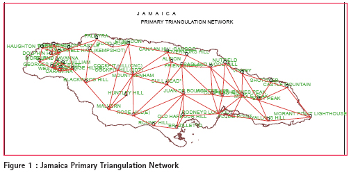
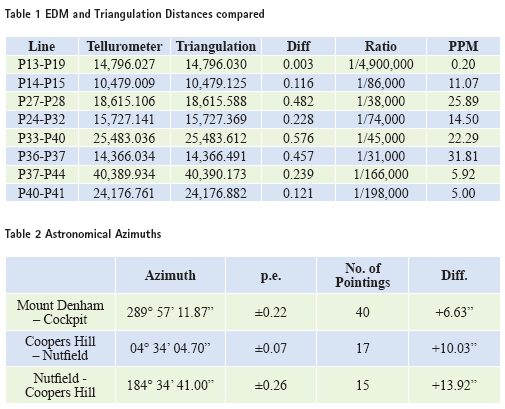
Virtual Reference System (VRS) comprises a network of three (3), or more, continuously operating Global Navigation Satellite System (GNSS) receivers, sited at points of known coordinates up to 70 Km apart and connected via data links. A control centre, with computer processing capability as well as a mobile phone data link, such as Global System for Mobile communication (GSM), is established for communication between the control centre and the users’ rover receivers. All receivers are linked via land line telephones to the control centre. Data from these receivers are fed into the control centre via the telephone links and used at the control centre to compute corrections for the two major sources of errors that affect GNSS measurements – and are easily mathematically modelled – ionospheric and tropospheric errors. Other errors/biases including satellite and receiver clock errors are removed by double and triple difference options, while those falling in neither category e.g., cycle slip and multipath errors, are minimized through the use of proper observational techniques. Any user with a GNSS receiver in the roving mode and connected, whether by wire or Bluetooth to a GSM ready cellular telephone, may dial into the control centre and send a standard National Marine Electronics Association (NMEA) position string which includes its coordinates as determined by the receiver autonomously, provided a signal is available. The control centre computes corrections for the rover as if the base station were at the rover’s position. This is what is regarded as the Virtual Reference Station. The configuration effectively eliminates the need for users to establish their own base station, as in the case of Real Time Kinematic (RTK), and translates into significant cost savings for those investing in GNSS technology. Of course users will have to pay providers for their cellular calls to the control centre. So far, there has been no indication of user fees to be charged by the National Land Agency of Jamaica, to the users of the VRS. The corrections transmitted to the rover from the control centre are good enough to yield centimeter accuracy for the coordinates of the rover station. This level of accuracy would be quite acceptable for most applications including Cadastral, Engineering Topographic, Hydrographic and Mining Surveying. Virtual Reference Systems may be mounted on an existing local geodetic control infrastructure where the reference stations occupy known control points. Alternatively, they may form a completely new network of points or indeed a combination of both. Since the safety and security of the equipment is of paramount importance, the locations of existing control points would not in all cases, be suitable for VRS Stations. In any event, the VRS network would be tied to the local geodetic control so that the control network can act as an integrity monitor for ground truthing the VRS coordinates. However, concerns have been raised as to whether the Jamaican control network in its current form can adequately support a VRS in this regard. The integrity monitoring feature of a National Control in support of a VRS, is a vital aspect of the use of VRS in Cadastral Surveying. Jamaica geodetic controlThe Jamaica Geodetic Control Infrastructure was originally established in three tiers, Primary, Secondary and Tertiary. The Primary network originally comprising of thirty-eight points was observed by Royal Engineers between November 1937 and April 1939. An additional six stations were subsequently incorporated by the Government Survey Department Surveyors to complete the network in 1944. The points form a mesh network of triangles spanning the length (230 km) and breadth (80 km) of the island. Typical side lengths range between 13km and 42 km. Given the nonexistence of Electromagnetic Distance Measurement (EDM) devices at that time, only one distance was measured and all the angles in each triangle were measured. The azimuth of one side was obtained through stellar observations. The datum point was established by connecting a point (Flagstaff at Fort Charles, Port Royal) to the United States of America (USA) Navy Department’s 1873 network of points where astronomical longitudes were observed between the United States mainland through a number of the West Indian Islands to Central America and South America. Observations for astronomical latitudes were made at the same time at each station where longitude was established. This gave rise to a Pure or Classical form of Triangulation (Figure 1). on a non-geocentric datum. A line of levels was run between a control station called Plumb Point and a mark on the officer’s bath (swimming pool) at Port Royal. The mark was reported by the British Admiralty to be 1.0668m (3.50 ft.) above mean low water as determined by the British Admiralty in 1886. The heights of all other primary triangulation stations were determined from reciprocal vertical angle measurements and related to the height of the Plumb Point Station. When Electronic Distance Measurement (EDM) became available, a campaign was launched to upgrade the network. Between 1961 and 1963, a Tellurometer was used to measure all the lines on the periphery of the primary triangulation network. A number of other lines were measured also. A comparison was made between the E.D.M distances (in feet) and those calculated from the triangulation. Table 1, provides some comparisons. The difference are all positive and exhibits a progressive deterioration in the scale of network as one goes from west –P13 (near the base) to east – P37 i.e. 1/4,900,000 to 1/31,000. This trend strangely reverses in areas in the east (P37-P41) where there are weak triangle misclosures, so that the ratios ‘improves’ to 1/198,000 (Robinson 1975) In 1959 the Inter American Geodetic Surveys (I.A.G.S.) observed a fi rst order azimuth for the line Mt. Denham to Cockpit. In 1968 Mr. Keith .A. Lee (Local Surveyor) of the Survey Department determined the azimuth of the line Coopers Hill to Nutfi eld reciprocally. The results and differences when compared with the R.E.’s azimuths for same lines are shown in Table 2. These differences in azimuth were considered large and followed a systematic pattern of these azimuths being greater than those calculated from the triangulation by the R.E.’s. Mr. K. Lee checked the R.E.’s computations for the azimuth Maxwell Hall to Etingdon and discovered an error of -10.39”. Mr. Lee’s check resulted in a computed azimuth of 81 16’ 46.64” as against the original computed azimuth of 81 16’ 36.24”. The application of this difference brought all four azimuths in closer agreement but still exhibiting an inconsistency of 7.29” between the lines Mt. Denham to Cockpit and Nutfi eld to Coopers Hill.(Mugnier, Cliff 2003) Further reductions by application of the Laplace Azimuth equation to the astronomical azimuths produced a +1.1” difference between the I.A.G.S. azimuth and the R.E. azimuth (corrected by K.A. Lee), for the line Mount Denham to Cockpit. This difference was far more acceptable for Primary Control standards. The error of -10.39” in the orientation of the triangulation network caused an anti-clockwise rotation of the network about the fixed point (Flagstaff at Port Royal), which resulted in a positional vector error for a point, say at Negril Lighthouse – 200km west, of 10m. This error varies directly with the radial distance of points from the Flagstaff. All modern maps of Jamaica produced prior to 1968 were based on this network and exhibits this system systematic error in the position of points. (Robinson, 1975).
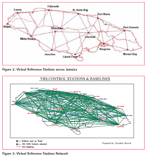
Re-adjustmentIn 1963, the then Survey Department requested the Directorate of Overseas Surveys to carry out a complete readjustment of the triangulation and E.D.M. traverse network. The reasons were: – • to homogenise all coordinates for points in the network • to take advantage of the E.D.M. traverse around the island to provide a new scale for the network. • to take advantage of the correct azimuth of the line, Maxwell Hall to Ettingdon • to include other observed azimuths to strengthen the orientation of the network. • to include additional observations (angular and linear) to strength the network. The primary triangulation network for the new (1969) adjustment consisted of observations taken by the Royal Engineers and additional measurements done by the Survey Department. At the same time it was decided to change spheroid and carry out all computations on the CLARKE 1866 spheroid instead of the then CLARKE 1880 spheroid. These decisions were agreed on by the Jamaica Survey Department and the Directorate of Overseas Surveys. The adjustment was computed by the variation of geographical coordinates and was completed in 1969. Hence the datum name JAD69 on which Latitudes and Longitudes/Northings and Eastings were published. The network remained in this form for another three decades until the National Land Agency decided to transition to a geocentric datum consistent with WGS84 named JAD2001. This datum was realised through the adoption of points established in the WGS84 datum, at the two (2) international airports by the United States of America National Geodetic Survey as part of a seventytwo (72) hour campaign carried out to establish accurate control at airports to support the improvement to takeoff/ landing infrastructure and ultimately the airports’ category rating. Existing triangulation control points (JAD69) were then coordinated from these points, using GNSS, as the Agency moved to densify the network by establishing new points in the JAD2001 datum. It is anticipated that the existing network of JAD69 points will be transformed into this new system using, for example grid fi le distortion modelling (Collier & Bowden 1999) or by readjusting the network, holding JAD2001 coordinates of JAD69 points fi xed, to achieve a complete renovation of the Geodetic Infrastructure. In the absence of a rigorous renovation of the national network through a dense observation campaign, with a complete adjustment on the WGS84/JAD2001 Datum, it is hoped that the result of the approach that the Survey and Mapping Division is taking, as articulated above, will render the geodetic infrastructure of a suffi cient accuracy to provide users of VRS a sound integrity monitor for their surveys. Jamaica VRS networkThe government of Jamaica under a contract to Spatial Innovision Limited, the regional dealers for Trimble products, has installed a Virtual Reference System constituted by thirteen continuously operating reference stations (CORS) across the island (see Figure 3). The system allows for the real-time augmentation of the information acquired by a single active receiver in the fi eld. The thirteen stations are placed across the island so as to enable full island coverage. This will allow for the use of VRS in any location where no less than three reference station receivers within a seventy kilometre range of that location, will provide a position fi x to an active receiver in real-time. The control centre, which is located at the National Land Agency (NLA) transmits differential corrections through a General Packet Radio Service (GPRS) cellular enabled network which is received in real-time allowing for on-site, realtime results. It is anticipated that this infrastructure will be a major boost to the effi ciency of the modern land surveyor. It is expected that the implementation of the Virtual Reference System will revolutionize the surveying and construction sectors as it will lower the cost of positioning. Unique and precise coordinates will be provided for each point that is coordinated with this system as it will be confi gured to function in the JAD2001 datum.
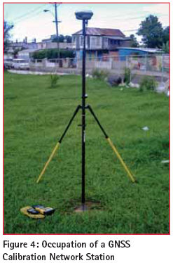
In this campaign, one (1) of the airport control and eleven (11) other existing points for which JAD2001 coordinates were previously determined during the NLA’s densifi cation program, were occupied; six (6) for eight (8) hours and the other six (6) for twenty-four (24) hours. In a constrained adjustment of the network in which the airport control and one (1) other point was held fi xed, the residuals at the other points ranged from -0.026m to +0.042m in Northings, -0.044m to +0.051m in Eastings and -0.555 to +0.269 in Height. The less than acceptable spread in the height residuals can be easily explained on the account of the status of our height control given earlier. While using VRS therefore, surveyors expect to achieve in the order of ±0.05 m in Northings and Eastings when checking or integrity testing the VRS before and after using the system for Cadastral Surveys. For the VRS to be of any value in Topographical and Engineering Surveys, substantial work needs to be done to improve our height control infrastructure. To be continued in next issue
|


 (12 votes, average: 3.92 out of 5)


Leave your response!