| GNSS | |
The benefits of future GNSS
|
||||
|
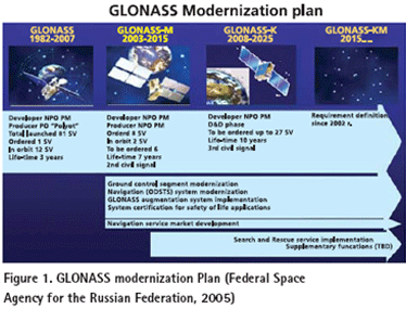
GLONASS GLONASS was originally deployed as the Soviet Union’s answer to GPS. The design of GLONASS is very similar to GPS except that each satellite broadcasts its own particular frequency with the same codes (this is known as a FDMA, or Frequency Division Multiple Access, scheme), while GPS satellites broadcast the same frequencies and a receiver differentiates between satellites by recognizing the unique code broadcast by a given satellite (this is known as a CDMA, or Code Division Multiple Access, scheme). GLONASS can also provide a different level of service to Military users compared to Civilian users. Since the collapse of the USSR, the Russian Federation has struggled to fi nd suffi cient funds to maintain GLONASS and there are only 14 satellites functioning (as opposed to the 24 necessary for full operational capability) at the present time. However, the Russian Federation has recently commenced a program to revitalize GLONASS (Federal Space Agency for the Russian Federation, 2005). * Current activity centers on launching GLONASS-M satellites with an improved 7-year design lifetime, which will broadcast in the L1 and L2 bands (though not on the same frequencies as GPS).From 2007 to 2008 it is planned to launch GLONASS-K satellites with improved performance, which will also transmit a third civil signal known as L3 (not the same frequency as GPS’s L5). The stated intention is to achieve a full 24 satellite constellation transmitting the two civil L1 and L2 signals by 2010. The full constellation is planned to be broadcasting three sets of civil signals by 2012, as illustrated in the Figure (1). It is worth noting that at the end of 2004 the Indian Government announced it would be contributing funds to assist Russia revitalize GLONASS. Although the frequencies of GPS and GLONASS are different, a single antenna can track all the transmitted signals. The data modeling challenges for integrated GPS/GLONASS processing have already been addressed, and survey-grade receivers capable of tracking both PS and GLONASS have been available for many years. These combined receivers have demonstrated a marked improvement in reliability and availability in areas where satellite signals can be obstructed, such as in urban areas or under tree canopies (Lachapelle, 2002). Galileo Perhaps the most exciting impact on the future of GNSSs is the decision by the European Union to launch its Galileo project. Both the US GPS and Russian GLONASS are under military control, whereas Galileo was originated from the desire of civilian service. In the early 1990s, the EU began to conceive its own global satellite navigation system for better and guaranteed coverage over northern Europe. The EC assumes political responsibility for Galileo and ESA leads the program development (European Commission, 2003). The design calls for a constellation of 30 satellites in a similar orbital confi guration to GPS, but at an increased altitude (approximately 3000km higher than GPS) which will enable better signal availability at high latitudes. While the Galileo design aims for a level of interoperability with GPS, some aspects are not compatible. Galileo satellites will broadcast signals compatible with the L1 and L5 GPS/GLONASS frequency bands. Those Galileo signals are designated as L1, E5a and E5b. Galileo will also broadcast in a third frequency band at E6; which is not at the same frequency as L2/L2C GPS/GLONASS. The details of the services from Galileo are subject to change but the current plan is to offer fi ve levels of service, two of which are fee-based and one of which is restricted: The Open Service uses the basic L1/L5 frequency band signals, free-toair to the public with performance similar to single- or dual-frequency GPS and GLONASS. The Safety of Life Service allows similar accuracy as the Open Service but with increased guarantees of the service, including improved integrity monitoring to warn users of any problems. This is a fee-based service. The Public Regulated Service is aimed at EU public authorities providing civil protection and security (e.g., police, quasi-military), with encrypted access for users requiring a high level of performance and protection against interference or jamming. The Search and Rescue Service is designed to enhance current space-based services by improving the time taken to respond to alert messages from distress beacons. The Commercial Service allows for tailored solutions for specifi c applications based on supplying better accuracy, improved service guarantees and higher data rates. This is a fee-based service. Ten navigation signals in the frequency range of 1164 ~ 1215 MHz (E5a and E5b), 1215 ~ 1300 MHz (E6) and 1559 ~ 1592 MHz (E2-L1-E11) are selected. Among those signals, six are accessible to all Galileo users on E5a, E5b and L1 as an OS and a SoL; two signals on E6 with encrypted ranging codes are only accessible to CS users, and the remaining two (one in the E6 band and one in the E2-L1-E1 band) with encrypted ranging codes and data are accessible to authorized users of the Public Regulated Service (PRS). The development of the Galileo system consists of three phases. During the fi rst phase (2001 to present), the mission requirements were consolidated, the satellites and ground based components were under developed, and the overall in-orbit validation (IOV) of Galileo was started. IOV includes the delivery of the fi rst four satellites in the Galileo constellation of 30, along with a number of ground control and monitoring stations. The fi rst launch of Galileo satellites was at the end of 2005. Now it is on the very edge to the second phase – deployment phase (before 2012), which covers the entire network of ground infrastructure and the launch of the remaining 26 satellites; then in the third phase starting from 2012, the whole system will become commercially operational. |
||||


 (No Ratings Yet)


