| GNSS | |
The benefits of future GNSS
|
||||
|
THE conventional geomatics industry including mapping and surveying applications has been revolutionized with the use of GPS, which is the best known, and currently fully operational satellite based navigation system operated by USA (Parkinson, and Spilker Jr., 1995). In the mean time, Russia also operates its own satellite based navigation system called GLONASS. The USA is modernizing GPS in order to retain its superiority in satellite based navigation technologies (MacDonald, 2002,). In order to keep up with USA’s progress in building next generation system, Russia is taking serious steps to modernize GLONASS as well (Federal Space Agency for the Russian Federation, 2005). The GPS and GLONASS signals are free but its availability is not guaranteed and currently most users are prepared to accept this risk (Parkinson, and Spilker Jr., 1995). However, as satellite navigation becomes a vital technology across a number of critical industrial sectors, the prospect of, for example, a nation’s transport infrastructure becoming dependent on this technology is a strategic risk that most industrial countries are not willing to accept. This argument initiated the Galileo program in Europe. Therefore, those systems form the mainframe of Global Navigation Satellite Systems (GNSS) (MacDonald, 2002,). Unlike GPS, Galileo will also offer a guaranteed service to users who are willing to pay for it (e.g. commercial service – CS, and Public Regulated Service PRS) in addition to a free signal similar to that of GPS (Open Service – OS and Safety of Life service – SoL). Galileo will be available to the public in 2012 (European Commission, 2003). Despite many technical differences between these three GNSS systems, the commonality of the carrier frequencies they use creates the potential for the future development of an interoperable GNSS receiver. The vast majority of the world will be users of these existing systems. The fundamental questions then are: “Which system or systems should a country use?”; “How to choose a combination of the systems?”; “What are the benefi ts and respective merits of those systems?” There is no simple answer to these questions, as the best solution will undoubtedly depend on the targeted application, which has its own requirements in terms of accuracy, reliability, robustness, cost and other application-specifi c criteria. What can be provided, however, is a means whereby parameters that describe these performance requirements can be computed. Comparing those pricy hardware GNSS simulators, high-accuracy software simulations are a cost-effective and precise tool to evaluate the performance characteristics attainable from the future GNSSs, and have been recognized as an appropriate pre-development tool for satellite navigation systems and applications in Canada and European countries. In addition, the entire hardware simulators available on the market can only emulate the signals from a single system at the present time. On the other hand, a dual systems simulator is easier to implement in the software level. The technical benefits of this approach lie in the fact that the software simulations are reproducible and totally controlled, and parameters can be changed individually if necessary for an in-depth understanding of the underlying effects. This paper introduces a qualitative assessment of the performance characteristics of the future GNSS infrastructure around Taiwan area using a multi-system software simulation toolkit being developed; therefore, representative results over Taiwan are demonstrated. Evolving From GPS to Future GNSSGPS Modernization GPS Modernization Motivated by the United States Department of Defense (DoD), the current GPS has experienced three decades’ development. Although the original motivation was only for military purposes, GPS has been widely used in civilian applications during the past few decades. However, the integrity, availability, and accuracy still need further improvement for various applications. For the surveying industry, applications can be classifi ed according to the achievable accuracy: * Single Point Positioning (SPP) is the technique for which GPS was originally designed and delivers the Standard Positioning Service (SPS) performance mentioned above. Differential GPS (DGPS) can overcome some of the limitations of GPS by applying corrections to the basic pseudorange measurements, based on a receiver making measurements at a known point (a reference station). The accuracy achievable from DGPS can range from a few meters down to few decimeters, depending on the quality of the receiver and the DGPS technique used (Parkinson, and Spilker Jr., 1995). * GPS Surveying also works differentially but can achieve centimeter accuracy using a special measurement technique. A typical receiver, for both SPP and DGPS1, measure the ranges to the satellites by timing how long the signal takes to come from the satellite (the pseudorange, referred to as such because this measurement is contaminated by the receiver clock error) (Lachapelle, 2002). However, receivers used in surveying and geodesy measure the phase of the underlying carrier wave signal (the so-called carrier phase). For baselines between points separated by more than 20km, it is important that such receivers can also correct for the ionosphere (Lachapelle, 2002). For shorter baselines, dual-frequency receivers are necessary for rapid initialization of cmlevel positioning. Given that civilians users only have access to the SPS, surveying receivers employ sophisticated signal processing techniques to measure the phase of the L2 signal. This level of sophistication is a major reason why surveying receivers are more expensive than receivers used for SPP and DGPS. Therefore, a GPS modernization program was initiated in the late 1990’s, in an attempt to upgrade GPS performance for both civilian and military applications. The GPS modernization program started with the cancellation of SA in 2000. It will be followed by the addition of a new a second civil code on L2 (L2C), then a third civil frequency L5. Further modernization consists of the assessment and design of a new generation of satellites to meet military and civil requirements through 2030. Table1 includes a summary of the launch schedule of the modernized GPS satellites according to MacDonald (2002). GPS Block IIR-M is the second part of Block IIR, with eight modernized satellites being built by Lockheed Martin. The IIRM satellites will have a new civil signal on L2 at higher signal power than normal IIR satellites. The Boeing Company has the contract for GPS Block IIF, with nine satellites in total that are intended to provide improved anti-jam capability, increased accuracy, higher integrity, and secured operational M-codes. Additionally, a third civil code at a new frequency L5 will also be included. The purpose of the GPS III program is to deliver major improvements in accuracy, assured service, integrity, and fl exibility for civil users. Currently led by both Lockheed Martin and Boeing both, the team of GPS III program has proposed the use of the same signal structure as Galileo for its open signals and decided the year 2012 as the target date of the launch of fi rst GPS III satellite. |
||||
|
||||
|
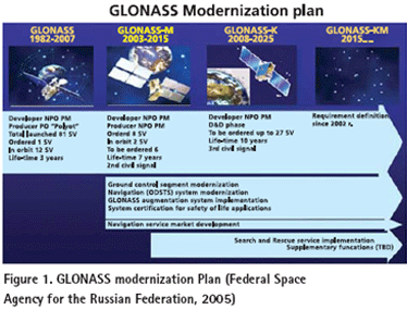
GLONASS GLONASS was originally deployed as the Soviet Union’s answer to GPS. The design of GLONASS is very similar to GPS except that each satellite broadcasts its own particular frequency with the same codes (this is known as a FDMA, or Frequency Division Multiple Access, scheme), while GPS satellites broadcast the same frequencies and a receiver differentiates between satellites by recognizing the unique code broadcast by a given satellite (this is known as a CDMA, or Code Division Multiple Access, scheme). GLONASS can also provide a different level of service to Military users compared to Civilian users. Since the collapse of the USSR, the Russian Federation has struggled to fi nd suffi cient funds to maintain GLONASS and there are only 14 satellites functioning (as opposed to the 24 necessary for full operational capability) at the present time. However, the Russian Federation has recently commenced a program to revitalize GLONASS (Federal Space Agency for the Russian Federation, 2005). * Current activity centers on launching GLONASS-M satellites with an improved 7-year design lifetime, which will broadcast in the L1 and L2 bands (though not on the same frequencies as GPS).From 2007 to 2008 it is planned to launch GLONASS-K satellites with improved performance, which will also transmit a third civil signal known as L3 (not the same frequency as GPS’s L5). The stated intention is to achieve a full 24 satellite constellation transmitting the two civil L1 and L2 signals by 2010. The full constellation is planned to be broadcasting three sets of civil signals by 2012, as illustrated in the Figure (1). It is worth noting that at the end of 2004 the Indian Government announced it would be contributing funds to assist Russia revitalize GLONASS. Although the frequencies of GPS and GLONASS are different, a single antenna can track all the transmitted signals. The data modeling challenges for integrated GPS/GLONASS processing have already been addressed, and survey-grade receivers capable of tracking both PS and GLONASS have been available for many years. These combined receivers have demonstrated a marked improvement in reliability and availability in areas where satellite signals can be obstructed, such as in urban areas or under tree canopies (Lachapelle, 2002). Galileo Perhaps the most exciting impact on the future of GNSSs is the decision by the European Union to launch its Galileo project. Both the US GPS and Russian GLONASS are under military control, whereas Galileo was originated from the desire of civilian service. In the early 1990s, the EU began to conceive its own global satellite navigation system for better and guaranteed coverage over northern Europe. The EC assumes political responsibility for Galileo and ESA leads the program development (European Commission, 2003). The design calls for a constellation of 30 satellites in a similar orbital confi guration to GPS, but at an increased altitude (approximately 3000km higher than GPS) which will enable better signal availability at high latitudes. While the Galileo design aims for a level of interoperability with GPS, some aspects are not compatible. Galileo satellites will broadcast signals compatible with the L1 and L5 GPS/GLONASS frequency bands. Those Galileo signals are designated as L1, E5a and E5b. Galileo will also broadcast in a third frequency band at E6; which is not at the same frequency as L2/L2C GPS/GLONASS. The details of the services from Galileo are subject to change but the current plan is to offer fi ve levels of service, two of which are fee-based and one of which is restricted: The Open Service uses the basic L1/L5 frequency band signals, free-toair to the public with performance similar to single- or dual-frequency GPS and GLONASS. The Safety of Life Service allows similar accuracy as the Open Service but with increased guarantees of the service, including improved integrity monitoring to warn users of any problems. This is a fee-based service. The Public Regulated Service is aimed at EU public authorities providing civil protection and security (e.g., police, quasi-military), with encrypted access for users requiring a high level of performance and protection against interference or jamming. The Search and Rescue Service is designed to enhance current space-based services by improving the time taken to respond to alert messages from distress beacons. The Commercial Service allows for tailored solutions for specifi c applications based on supplying better accuracy, improved service guarantees and higher data rates. This is a fee-based service. Ten navigation signals in the frequency range of 1164 ~ 1215 MHz (E5a and E5b), 1215 ~ 1300 MHz (E6) and 1559 ~ 1592 MHz (E2-L1-E11) are selected. Among those signals, six are accessible to all Galileo users on E5a, E5b and L1 as an OS and a SoL; two signals on E6 with encrypted ranging codes are only accessible to CS users, and the remaining two (one in the E6 band and one in the E2-L1-E1 band) with encrypted ranging codes and data are accessible to authorized users of the Public Regulated Service (PRS). The development of the Galileo system consists of three phases. During the fi rst phase (2001 to present), the mission requirements were consolidated, the satellites and ground based components were under developed, and the overall in-orbit validation (IOV) of Galileo was started. IOV includes the delivery of the fi rst four satellites in the Galileo constellation of 30, along with a number of ground control and monitoring stations. The fi rst launch of Galileo satellites was at the end of 2005. Now it is on the very edge to the second phase – deployment phase (before 2012), which covers the entire network of ground infrastructure and the launch of the remaining 26 satellites; then in the third phase starting from 2012, the whole system will become commercially operational. |
||||
|
||||
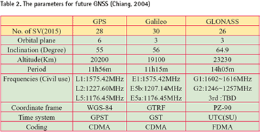
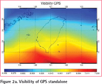
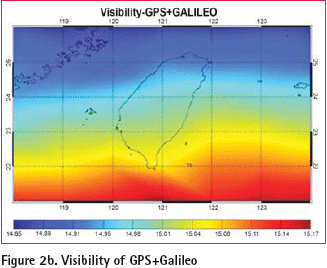
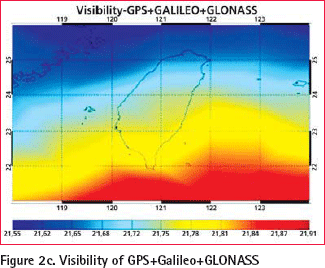
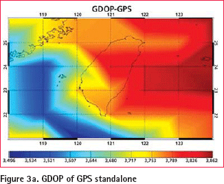
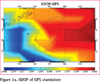
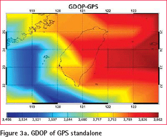
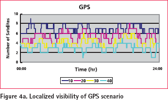
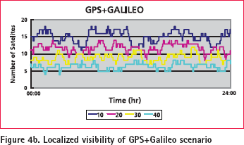
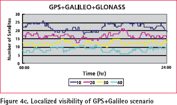
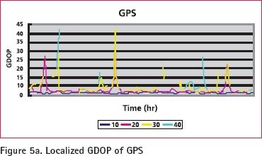
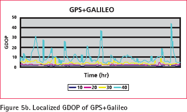
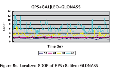
Multi-constellation GNSSBased on the system parameters given previously, future GNSS is expected to provide at least nine frequencies with more than eighty satellites when all the systems become fully operational. Table 2 illustrates the parameters for future GNSS by year 2015. It can be seen from the above descriptions that the next generation GNSS will bring signifi cant improvements compared to current systems. In ten years time there may be as many as 80 satellites from GPS, GLONASS, and Galileo, broadcasting a variety of signals and codes by suitably equipped users for a range of navigation and positioning applications. The L1 signal alone is suffi cient for many massmarket applications requiring an accuracy of (say) 3 to 10 meters. The availability of many more satellites will enable new applications in areas where the current lack of satellites has been a hindrance to market growth (Rizos, 2005). More Satellites to Users Simulation studies were carried out in order to determine the improvements to regional satellite visibility and dilution of precision (DOP) for a combined GPS/GLONASS/Galileo system. The analyses are based on the GPS, GLONASS and Galileo satellite coordinates and given receiver coordinates. The GPS satellite coordinates were determined by using actual ephemeris (converted from the almanac fi les). The nominal constellation for the complete GLONASS as described in the GLONASS Interface Control Document was used (Lachapelle, 2002). The Galileo constellation was compiled from information in Dinwiddy et al. (2004). The implemented GLONASS constellation was essentially 24 satellites in three orbital planes whose ascending nodes are 120° apart. 8 satellites are equally spaced in each plane with argument of latitude displacement 45°. The orbital planes have 15° argument of latitude displacement relative to each other. The satellites operate in circular 19100km orbits at an inclination 64.8°. The Galileo constellation comprises 27 operational satellites in a Walker constellation with three orbital planes, equally spaced with a 56° nominal inclination and an altitude of 23222km. Each orbital plane contains nine satellites, nominally 40° apart and one spare. Simulations have been performed as though the complete GLONASS and Galileo systems were operational at the time of the GPS almanac validity. The simulated measurements are based on a single-frequency point positioning scenarios commencing at 00h 3 August 2006. The span of the simulation was 24 hours. The satellite visibilities for the GPS, GPS/Galileo and a combined GPS/GLONASS /Galileo system with a masking angle of 10° around Taiwan are shown in the Figure (2a), Figure (2b), and Figure (2c), respectively. The combined system indicates an average of about 21 visible satellites over the 24 hour period. At the time of the simulations the GPS has an average of about 7 visible satellites. The GPS and Galileo combined constellations offers on average 15 visible satellites. General speaking, the number of satellites decreases when the latitude of the user increases. In other words, users in southern Taiwan tend to have better satellite visibility than those who in northern Taiwan. Similarly, Figures (3a) to (3c) illustrate the regional GDOP distribution for the GPS, GPS/Galileo and a combined GPS/GLONASS /Galileo system with a masking angle of 10° around Taiwan. The averaged GDOP levels of the dual system are improved approximately 60% of the levels for the standalone GPS scenario. In addition, the averaged GDOP levels of triple systems are improved approximately 80% and 20% comparing to GPS and GPS/ Galileo systems, respectively. Figures (4a) to (4c) illustrate the distribution of localized visibility at the Tainan City (λ=120, φ=23) against raising masking angles (10o, 20o, 30o, and 40o). Similarly, Figures (5a) to (5c) illustrate the distribution of localized GDOP at the same location against varying masking angles. Figures (4) and (5) indicate that the availability and reliability in the urban environment are improved with the increasing number of satellites, therefore, both surveying and navigation communities will fi nd the signifi cance of future GNSS. |
||||
|
||||||||||||||||||||||||||||||
The Benefi ts of More SatellitesThe benefi ts of extra satellites have already been proved by GPS and GLONASS combined system. Galileo brings all that and more. The benefi ts of the expected extra satellites and their signals outlined above can be categorized in terms of availability, accuracy, continuity, reliability, effi ciency, and ambiguity resolution issues. Availability One of the most important benefi ts of simultaneously using GPS, Galileo, and GLONASS is the improvement in availability, especially in urban areas, as indicated in the previous section. From another point of view, the potential of GPS and Galileo to work as mutual backups is able to improve the reliability when either system is under some type of failure. Accuracy More satellites to observe means a given level of accuracy can be achieved sooner. More signals means more measurements can be processed by the receiver’s positioning algorithm. Positioning accuracy is less susceptible to the infl uence of satellite geometry. The effects of multi-path and interference/ jamming are mitigated; mean meaning the measurement quality is higher. Continuity GPS, GLONASS and Galileo being independent GNSS means major system problems, unlikely as they are, are a very remote possibility of occurring simultaneously. Reliability With extra measurements the data redundancy is increased, which helps identify any measurement outliers. The new measurements will be more independent than the current L1 and L2 measurements, because code-correlation techniques (based on knowledge of the PRN modulating range codes) will be used, rather than the ‘codeless/ cross-correlation’ techniques employed in today’s dual-frequency GPS receivers. The current L2 GPS measurements by survey-grade receivers are noisier and less continuous than those expected to be made on either of the new signals L2C or L5, hence reliable dualfrequency operation will be enhanced. More signals means that service is not as easily denied due to interference or jamming of one frequency that may prevent the making of critical pseudorange and/or carrier phase measurements. It may. However, there will be an impact on effi ciency (in terms of time to- ambiguity resolution) if not all frequencies/codes can be tracked. It should also be emphasized that newer systems, with improved electronics and antennas in the satellites and user receivers, will deliver overall improvements in data quality. Efficiency For carrier phase-based positioning, to centimeter accuracy, the extra satellite signals will signifi cantly reduce the time required to resolve ambiguities. In addition, the density of GNSS reference stations to support differential positioning using triple-frequency techniques may also be reduced signifi cantly. Ambiguity resolution The improvement in UERE will lead to an improvement in the SPS standalone accuracy and will enable a better initial receiver position to perform ambiguity resolution. Both the accuracy of the initial receiver position and the UERE will impact the estimation of fl oat ambiguities. A better estimation of fl oat ambiguities will bring more ease in the integer ambiguity fixing. Poor geometry might lead to degradation in the stand-alone positioning accuracy, given a certain magnitude of UERE. A large offset in the initial position might result in slow ambiguity fi xing or even incorrect fi xing if the position converges to an incorrect place due to the poor geometry. When both GPS and Galileo are simultaneously in operation, compared to the case of GPS only, there would be a global improvement in the constellation geometry since more than 50 satellites will be available. In this regard, there will also be a corresponding global improvement in ambiguity resolution. Ambiguity resolution directly on L1/E1 is very diffi cult since the wavelengths are so short that the measurements of L1/E1 are susceptible to ionospheric errors and other errors. However, the proper combination of the phases on the two carrier frequencies might have benefi ts of a longer wavelength and lower vulnerability to ionospheric errors or other errors, so the ambiguity may be easier to fi x than for L1/E1 ambiguities. Once three frequencies are available, more combinations among the phases of different carrier frequencies are possible. ConclusionsA technical benefi t of the geomatics and surveying industry in Taiwan is given in this article. The USA is modernizing GPS, Russia is refreshing GLONASS, and Europe is moving ahead with its own Galileo system. Extra satellites will make possible improved performance for all applications, and especially where satellite signals can be obscured, such as in urban canyons, under tree canopies or in open-cut mines. The benefi ts of the expected extra satellites and their signals outlined above can be categorized in terms of availability, accuracy, continuity, reliability, effi ciency, and ambiguity resolution issues. All the performance indices given in this article strongly indicate the benefi ts of future GNSS. AcknowledgementThis study was supported in part by research fund from the Land Survey Bureau of Taiwanese (LSB- 095-08) and National Science Council of Taiwan (NSC 95-2221-E-006 -335 -MY2). European Space Agency (ESA) is acknowledged for sharing its expertise and knowledge in Galileo simulation. References 1. K.W. Chiang, 2004, “INS/GPS Integration Using Neural Networks for Land Vehicular Navigation Applications”, Department of Geomatics Engineering, The University of Calgary, Calgary, Canada , UCGE Report 20209 |
||||||||||||||||||||||||||||||
|
||||||||||||||||||||||||||||||
|



 (No Ratings Yet)


