| Applications | |
Sustainable Land Governance
|
||||||||||||||||
|
All countries have to deal with the management of land. They have to deal with the four functions of land tenure, land value, land use, and land development in some way or another. National capacity may be advanced and combine the activities in one conceptual framework supported by sophisticated ICT models. More likely, capacity will involve very fragmented and basically analogue approaches. Different countries will also put varying emphasis on each of the four functions, depending on their cultural basis and level of economic development. Today the accepted theoretical framework for all land administration systems is delivery of sustainable development – the triple bottom line of economic, social, and environmental development, together with the fourth requirement of good governance. Land Administration Systems are the basis for conceptualizing rights, restrictions and responsibilities related to people, policies and places. Property rights are normally concerned with ownership and tenure whereas restrictions usually control use and activities on land. Responsibilities relate more to a social, ethical commitment or attitude to environmental sustainability and good husbandry. This paper provides an overall understanding of the concept of land administration systems for dealing with rights, restrictions and responsibilities in future spatially enabled government.
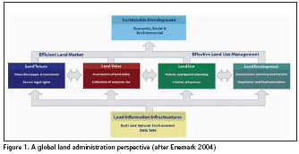
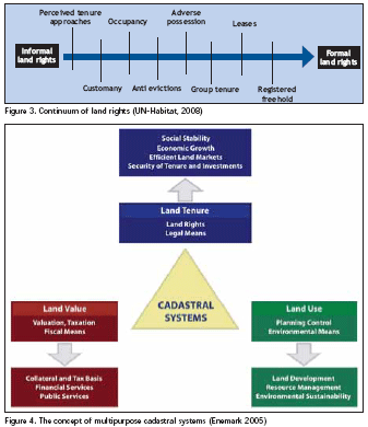
Land administration systemsLand Administration Systems (LAS) are an important infrastructure, which facilitate the implementation of land policies in both developed and developing countries. LAS are concerned with the social, legal, economic and technical framework within which land managers and administrators must operate. These systems support efficient land markets and are, at the same time, concerned with the administration of land as a natural resource to ensure its sustainable development. This global approach to modern land administration systems is shown in Figure 1. The four land administration functions (land tenure, land value, land use, land development) are different in their professional focus, and are normally undertaken by a mix of professions, including surveyors, engineers, lawyers, valuers, land economists, planners, and developers. Furthermore, the actual processes of land valuation and taxation, as well as the actual land use planning processes, are often not considered to be part of the land administration activities. However, even if land administration is traditionally centred on the cadastral activities in relation to land tenure and land information management, modern LAS designed as described in Figure 1 delivers an essential infrastructure and encourages integration of the four functions: Land tenure: the processes and institutions related to securing access to land and inventing commodities in land, and their allocation, recording and security; cadastral mapping and legal surveys to determine parcel boundaries; creating new properties or altering existing properties; the transfer of property or use from one party to another through sale, lease or credit security; and the management and adjudication of doubts and disputes regarding land rights and parcel boundaries. Land value: the processes and institutions related to assessment of the value of land and properties; the calculation and gathering of revenues through taxation; and the management and adjudication of land valuation and taxation disputes. Land use: the processes and institutions related to control of land use through adoption of planning policies and land use regulations at national, regional and local levels; the enforcement of land use regulations; and the management and adjudication of land use conflicts. Land development: the processes and institutions related to building of new physical infrastructure and utilities; the implementation of construction planning; public acquisition of land; expropriation; change of land use through granting of planning permissions, and building and land use permits; and the distribution of development costs. Inevitably, all the functions are interrelated. The interrelations appear through the fact that the actual conceptual, economic and physical uses of land and properties influence land values. Land values are also influenced by the possible future use of land determined through zoning, land use planning regulations, and permit granting processes. And the land use planning and policies will, of course, determine and regulate future land development. Land information should be organised to combine cadastral and topographic data, and to link the built environment (including legal and social land rights) with the natural environment (including topographical, environmental and natural resource issues). Land information should, this way, be organised through an SDI at national, regional, federal, and local levels, based on relevant policies for data sharing, cost recovery, access to data, data models, and standards. Ultimately, the design of adequate systems of land tenure and land value should support efficient land markets capable of supporting trading in simple and complex commodities. The design of adequate systems to deliver land use control and land development should lead to effective land use management. The combination of efficient land markets and effective land use management should support economic, social and environmental sustainable development. From this global perspective, LAS act within adopted land policies that define the legal regulatory pattern for dealing with land issues. They also act within an institutional framework that imposes mandates and responsibilities on the various agencies and organisations. They should service the needs of individuals, businesses, and the community at large. Benefits arise through LAS guarantee of ownership, security of tenure and credit; facilitating efficient land transfers and land markets; supporting management of assets; and providing basic information and efficient administrative processes in valuation, land use planning, land development and environmental protection. LAS designed in this way forms a backbone for society and is essential for good governance because it delivers detailed information and reliable administration of land from the basic foundational level of individual land parcels to the national level of policy implementation. Property rightsIn the Western cultures it would be hard to imagine a society without having property rights as a basic driver for development and economic growth. Property is not only economic asset. Secure property rights provide a sense of identity and belonging that goes far beyond and underpins the values of democracy and human freedom. Historically, however, land rights evolved to give incentives for maintaining soil fertility, making land-related investments, and managing natural resources sustainably. Therefore, property rights are normally managed well in modern economies. The main rights are ownership and long term leasehold. These rights are typically managed through the cadastral/ land registration systems developed over centuries. Other rights such as easements and mortgage are often included in the registration systems. However, these legal or formal systems do not serve the millions of people whose tenures are predominantly social rather than legal. “Rights such as freehold and registered leasehold, and the conventional cadastral and land registration systems, and the way they are presently structured, can not supply security of tenure to the vast majority of the low income groups and/ or deal quickly enough with the scale of urban problems. Innovative approaches need to be developed” (UN- HABITAT 2003). This should include a “scaling up approach” that include a range of steps from informal to more formalised land rights. This process does not mean that the all societies will develop into freehold tenure systems. Figure 3 shows a continuum of land rights where each step in the process can be formalised, with registered freeholds offering a stronger protection, than at earlier stages.
Cadastral Systems Modern land administration theory relied on the history of cadastres to demonstrate their vitality as a central tool of government infrastructure, and then constructed their central role in implementing the land management paradigm. However, given the difficulty of finding a definition that suits every version, it makes sense to talk about cadastral systems rather than just cadastres (Figure 4). These systems include the interaction between the identification of land parcels and the registration of land rights, and they support the valuation and taxation of land and property, and the administration of present and possible future use of land. The concept of these multipurpose cadastral systems is shown as engaging the systems (the central triangle in Figure 4) to deliver the four functions of land tenure, value, use and development, and to deliver sustainable development outcomes. By 2000, cadastral systems were seen as a multipurpose engine of government operating best when they served administration functions in land tenure, value, use and development, and focused on delivering sustainable land management. A mature multipurpose cadastral system could even be considered as LAS in itself. This multipurpose design was the touchstone of best practice, sought by many LAS designers and managers. Achieving this however is another story because each unique existing system needs a different group of strategies to implement the proposed multipurpose design. Comparing Cadastral Systems A website has been established http://www. cadastraltemplate.org to compare cadastral systems on a worldwide basis. About 40 countries are currently included (August 2007) and the number is still increasing. The web site is established as a result of one of the objectives of Working Group 3 “Cadastre” of the PCGIAP (Permanent Committee on GIS Infrastructure for Asia and the Pacific). The cadastral template is basically a standard form to be filled out by cadastral organizations presenting their national cadastral system. The aims are to understand the role that a cadastre plays in a state or a National Spatial Data Infrastructure (NSDI), and to compare best practice as a basis for improving cadastres as a key component of NSDIs. The Cadastral template project is carried out in collaboration with Commission 7 “Cadastre and Land Management” of the International Federation of Surveyors (FIG), which has extensive experience in comparative cadastral studies. (Steudler, et.al. 2004). It is generally accepted that a good property system is a system where people in general can participate in the land market having a widespread ownership where everybody can make transactions and have access to registration. The infrastructure supporting transactions must be simple, fast, cheap, reliable, and free of corruption. And the system must provide safety for housing and business, and for capital formation. It is estimated that only 25-30 countries in the world apply to these criteria. To be concluded in December issue. |
||||||||||||||||
|
||||||||||||||||


 (36 votes, average: 1.67 out of 5)


Leave your response!