
China launches high-resolution remote-sensing satellite
China has successfully sent a highresolution multi-mode imaging satellite into the planned orbit from the Taiyuan Satellite Launch Center in north China’s Shanxi Province recently. The satellite is a civil-use optical remote-sensing satellite with a resolution up to the sub-meter level. It will operate in Sun-synchronous orbit.
It can provide high-precision remotesensing …
Hyundai Robotics and Hyundai E&C to develop construction robots
Hyundai Robotics, Korea’s No. 1 industrial robot producer, has joined hands with Hyundai E&C to develop construction robots. Through this MoU, both companies will jointly carry out
• The development of robots working at construction sites
• Mobile service robot business
• Development of core technologies …
VSR700 prototype performs first autonomous free flight
The prototype of Airbus Helicopters’ VSR700 unmanned aerial system (UAS) has performed its first free flight. It performed a ten-minute flight at a drone test centre near Aix-en-Provence in the south of France. It derived from Hélicoptères Guimbal’s Cabri G2, is an unmanned aerial system in the 500-1000 kg …
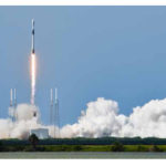
SpaceX launches third GPS Block III satellite
SpaceX launched their Falcon 9 rocket with the third Block III GPS satellite, named SV03. Block III is the next generation of GPS satellites, replacing the aging Block II series. This will be SpaceX’s second GPS launch, out of the five they have been awarded so far.
SpaceX previously launched …
Bentley Systems’ The Cohesive Companies
Bentley Systems, Incorporated has announced that its Acceleration Fund has launched The Cohesive Companies, a wholly owned subsidiary, anchored by the acquisition of Atlanta-based Cohesive Solutions. The new business venture will include the services team from Bentley’s AssetWise business and the offerings of Bentley, Cohesive, and IBM’s Maximo to support the …

The safety of engineering structures requires periodic inspection. Assessing the condition of the structure and its behavior cannot be done without a regular and frequent monitoring by establishing a network of geometric auscultation. The contribution of an analytical tool in the management of this network is the purpose of this work…

This paper is intended to establish living structure – a physical phenomenon and mathematical concept – as a formal concept or foundation for maps and mapping
Bin Jiang
Professor, Faculty of Engineering and Sustainable Development, Division of GIScience, University of Gävle, Sweden
Terry Slocum
Professor, Department of Geography and Atmospheric Science, University of Kansas, Lawrence, USA
Abstract
The Earth’s surface or …

Volume XVI, Issue 7, July 2020
Transforming the old map series to the modern geodetic reference system
Georgios Moschopoulos, Nikolaos Demirtzoglou, Antonios Mouratidis, Dionysia-Georgia Perperidou and Dimitrios Ampatzidis
Clipper Adventurer Grounding
Bruce Calderbank
Covid-19 and the Surveying Profession: A New …
AI enabled technology to ensure social distancing
Amazon has launched an artificial intelligence-based tracking system to enforce social distancing at its offices and warehouses to help reduce any risk of contracting the new coronavirus among its workers. One of the early solution developed at Amazon applies artificial intelligence and machine learning to the camera footage in …
Indian Government issues draft rules for manufacturing and using drones
The Civil Aviation Ministry of India issued draft rules for manufacturing drones and using it in the country. As per the new policy authorized manufacturer or importer can sell its devices only to an individual or entity approved by the aviation regulator DGCA. The draft …


 (5.00 out of 5)