
WingXpand, Raytheon AI collaboration
WingXpand has collaborated with RTX’s Raytheon. The partnership aims to enhance the capabilities of WingXpand’s smart planes. The smart planes’ open systems architecture allows for the seamless integration of organic and third-party applications and payloads, designed for mission flexibility as threats and tactics evolve. Raytheon’s advanced infrared technology seeks to enhance …
Quantum-sensing technology for alternative PNT by Royal Navy
The Royal Navy, UK has successfully tested a new quantum sensing technology designed for underwater detection. Conducted off the coast of Plymouth aboard HMS Magpie, the trials aimed to evaluate the effectiveness of this quantum-sensing system in identifying submerged objects.
The technology leverages ultra-cold atoms to measure …
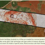
Lidar helps uncover lost Mayan city
Using laser-guided imaging to peer through dense jungle forests, Tulane University researchers have uncovered vast unexplored Maya settlements in Mexico and a better understanding of the ancient civilization’s extent and complexity.
…

The objective of this study is to create a new platform for the automated detection of irregularly shaped man-made marine objects (ISMMMOs) in large datasets derived from marine aerial survey imagery. Readers may recall that we published the first part of the paper in October issue. We present here the concluding part
Kaya Kuru
School of Engineering …

The proposed method is implemented in our college academic block and the experimental results show that our navigation method is feasible and effective
R.Deiva Nayagam
Assistant Professor, Department of ECE, Ramco Institute of Technology, Rajapalayam-626117, Tamilnadu, India
D.Selvathi
Senior Professor & Head, Bio Medical Engineering Programme, Mepco Schlenk Engineering College, Sivakasi, India.
R.Geeta
Assistant Professor, Department of ECE, Chennai Institute of …

Urban policies, resettlement and low-cost housing are the powerful tools of the poverty reduction which transform the lives of the poor
…
Development of the future combat air system (FCAS)
UAV Navigation-Grupo Oesía has announced that SATNUS (a company formed by GMV, Sener Aeroespacial and Tecnobit-Grupo Oesía) has counted on its collaboration in the ambitious European program Future Combat Air System (FCAS). This program aims to develop a future-generation …
SPH Engineering, Radar Systems, Inc., launch GPR
SPH Engineering, in partnership with Radar Systems, Inc., have launched of a Ground Penetrating Radar (GPR) model, Zond Aero 500 NG, the first of its kind model to be designed for both terrestrial and drone-mounted surveys. GPR Zond Aero 500 NG …
USGS experts responding to two major natural hazards
As U.S. Geological Survey staff prepare for Hurricane Milton to hit Florida’s west coast, agency experts are still dealing with the after-effects of Hurricane Helene that made landfall in Florida late last month and continued a path of destruction north through Georgia, North Carolina, South Carolina and Tennessee.
While …
ESA launches Moonlight to establish lunar communications and navigation infrastructure
ESA has officially launched its Moonlight programme, a landmark initiative to create a satellite constellation orbiting the Moon for communications and navigation services. With over 400 planned lunar missions by space agencies and private companies in …


 (5.00 out of 5)