

THE land-sea interface is one of the most complex areas of management in the world consisting of both the marine and terrestrial environments. The coastal zone is also home to an increasing number of activities, rights and interests. Population along the coastline is continuously increasing, bringing about new pressures on the fragile eco-system of the coastal zone. This has brought with it an increased need to more effectively and efficiently manage this area to meet the economic, environmental and social outcomes of sustainable development.

LAND forms important part of development activity. Land revenue is one of the sources of income for state governments. It may come from land holdings by private individuals, real estate transactions or other natural resources being tapped by various sections of the society. Hence, creation of a Land Information Management System involves
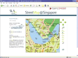
Singapore Land Authority puts map-based land ownership information on the Net
Imagine: you want to know whether a plot of land or a building is state or privately-owned in order to tip-off a case of mosquitoesbreeding, overgrown or fallen trees, illegal parking, noise pollution, or even rubbish dumping. Imagine: you are interested to rent space and …
For anyone serving in India during the 19th and early 20th century life …

Land administration systems evolved from a focus on core functions of regulating land and property development, land use controls, land taxation and disputes (Dale & McLaughlin, 1999) to an integrated land management paradigm designed to support sustainable development (Enemark et al., 2005).
JAVAD introduces US-built GNSS board for LEO applications
JAVAD GNSS has announced the TR 2S LEO, a compact GNSS OEM board designed and manufactured at the company’s headquarters in San Jose, California. The TR-2S LEO delivers high-precision GNSS positioning for low Earth Orbit (LEO) missions.
Developed for customers requiring …
UK invests in satellite timing to boost national PNT resilience
GMV is leading the development of a secure two-way satellite time and frequency transfer system under the European Space Agency’s TOUCAN Project – the two way satellite time and frequency transfer capability demonstration (TWSTFT).
The initiative safeguards critical infrastructure …
White-label CAD solution in Japan
Pythagoras BV and Terra Drone have formed a strategic partnership to introduce a customized white-label software solution for the Japanese market. It combines Terra Drone’s SLAM and UAV technologies with Pythagoras’ CAD and point cloud processing software, creating an integrated platform tailored …

A holistic summary of important criteria needed for safe and successful flights
Tito Jun T. Tidula
A former UAV operator/ controller who operated both fixed wing and multirotor drones and is currently a faculty member in the Department of Agricultural and Biosystems Engineering, College of Engineering and Information Technology, University of Southern Mindanao, Kabacan, Cotabato, Philippines
Rezin G. …


 (5.00 out of 5)