| GIS | |
River Yamuna in Delhi-Pollution control, digital planning and management
A judicious integration of ecological scientific research, digital planning and management is necessary to keep the urban river clean and flowing. This requires committed participation of the local communities. The cultural and traditional connect with water, as reflected in traditional water structures, and purification customs, can be potential social tools to involve the masses to conserve water resources and to prevent pollution of river |
 |
|
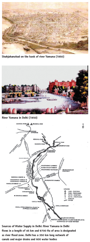
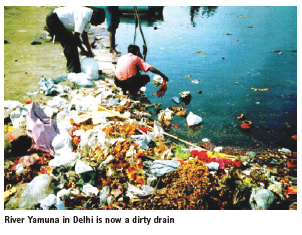
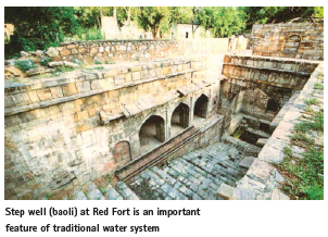
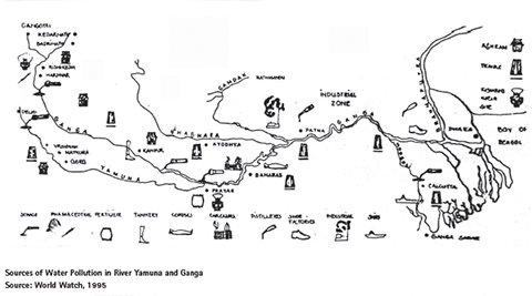
From times immemorial, the cities, agriculture and culture evolved along the rivers. Among various Delhi’s, Shahjahanabad (17th Century), was built along the river Yamuna, a 1370 km long river emanating from the Himalayas and merging into the River Ganga at Prayag. However, with indiscriminate urbanisation River Yamuna in Delhi has become a dirty drain. The river zone covering 9700 Ha in the midst of Delhi has been encroached upon, used for power stations, sanitary landfill, bus depot and parking, construction of roads, grid sub-stations, samadhis, housing, offices, stadia, temples, cremation ground, an IT Park, metro depot and various other activities. More than 70 unauthorised colonies have come up in the area, which have altered the river regime and its water quality.
About 90 per cent of river water is diverted into drains and canals upstream and most of the remaining water is stored for urban use, leaving the river high and dry, especially during the summer. River without a continuous flow lacks oxidation and becomes stagnant and polluted. A significant problem is eutrophication which results from the excessive levels of nutrients in municipal, industrial, irrigation and drainage effluents. Nearly 75% of pollution of river is from municipal sewage with the balance coming from effluents generated from industries, run-off from agricultural fields, solid waste dumps, open defecation, etc. The analysis of the water quality data along the length of the river reveals the following:
i. The levels of Dissolved Oxygen (DO) above the threshold limit (5 mg/ litre)
ii. The levels of Biochemical Oxygen Demand (BOD) above the acceptable limit of 3 mg/ litre.
iii. The higher levels of coliform (faecal and total) count in the river water.
It is estimated that during last 50 years freshwater vertebrate in the river have declined by 83%, groundwater has depleted and there is a serious loss of biodiversity. The construction of embankments to bind the floodplain has constricted the water flow, resulting into frequent flooding, construction of unauthorised colonies, real estate projects, roads and flyovers in the river flood zone.
Biodiversity, land form and the river
There is a close relationship between the landform and the river. Its maze-like structure reflects and celebrates a kinesthetic and topographic abstraction of space. As such, river can’t be separated from the network of canals and drains. These are valuable hydrological and ecological resources, which with the indiscriminate urbanization have become the corridors of filth, garbage, squatting, insanitation and beds of mosquitoes, stray and dead animals. These canals and drains can be developed as green corridors with jogging tracks, pedestrian and cycle pathways. Historical water system and structures, baoli, embankments, sluice gates, lakes, catchment areas, canals, etc. can be protected by green portals and kept alive by the public activities.
Keeping the river flowing
A major problem which affects the overall health of the river relates to non-availability of adequate water flow. The river Yamuna cannot be made pollution free unless the adequate flow is maintained. The Supreme Court of India in 1999 directed that a minimum10 cumecs of water be ensured in the river Yamuna throughout, together with pollution abatement and up-gradation of water quality. The availability of water in the river throughout the year is not only important for making it lively and pollution free, but also to meet the burgeoning demand of water supply by capacity augmentation of the existing reservoirs and local collection of the monsoon water.
Huge quantities of human, industrial, tanneries and solid and liquid wastes are carried by 22 major drains falling into the river Yamuna in Delhi. These drains dump solid wastes, sewage and wastewater in the river. These violate the Water (Prevention and Control of Pollution) Act, 1974, and Environment Protection Act 1986. The installation of treatment facilities (STPs and ETPs) by polluting units and surrounding urban areas, and their efficient and effective functioning are essential.
While curative actions, such as installation of treatment facilities are necessary, more important is preventive action. This involves removal of non-compatible and pollution generating land uses from the river zone and also cleaning of major drains and controlling the dumping of solid waste and untreated sewage into rivers and drains.
Reducing river pollution
Causes of contamination of river water are indiscriminate use of fertilisers and chemicals, poor hygienic environment of the water sources, improper disposal of sewage and solid waste, pollution from untreated industrial effluents, and over-exploitation leading to quality degradation. Of all the pollutants, urban sewage may be the worst offender in near-urban waters, although industrial pollutants can be a major source. In addition, up to half of the contaminants reaching urban waters come from non-point sources, such as urban runoff.
Thus, the supply of additional quantity of water by itself does not ensure good health; proper handling of water and prevention of contamination are also equally important.
Among the most important elements of the public health package are:
• Safe drinking water
• Disposal and recycling of wastewater
• Safe disposal of human excreta which is associated with more than 50 per cent diseases
• Safe solid waste disposal
• Sanitation and hygiene
• Personal hygiene, cleanliness and use of toilets
• Community Sanitation.
By reducing river pollution, cities can reap the double benefit of effectively increasing the water supply while lessening the deterioration of the aquatic environment. As the “pollution shadow” spreads, cities go further to find water, which significantly increases the costs of water supply.
Controlling urban runoff, although difficult, is essential if cities are to mitigate their impacts on nearby water bodies.
Regional water resources can only be properly managed at the river basin level. It is therefore necessary to have planning and control for the whole river basin. Groundwater, for which various government departments share responsibility, should be managed as a unified regional management framework.
Because of the urbanisation and demand for groundwater, aquifers are vital water resource management.
Urbanisation, removal of forest cover and the addition of impervious surfaces have increased frequency of flooding and changed stream characteristics. By adopting, the natural drainage system, water-table recharges and increases lag time for run-off. Protection of flood plain and drainage are imperative for flood control, for regulating stream control and for maintaining water quality.
Innovative and economical solutions like primary treatment, bio-remediation, oxidation ponds, aeration, etc. can be employed to treat waste water. For treatment of pesticide traces, capping the existing sand bed with bituminous charcoal or coconut shells can be an easy and inexpensive solution. Increasing flocculants by adding powered activated carbon (PAC) or bentonite clay with doses varying from 25-30 mg/l and the use of granular activated carbon can be effective, subject to its cost. Raw water tanks and rainwater storage can be protected by clay beds, which should be secured from getting washed away during the monsoons. The best way to get rid of the pesticides (non-point) and industrial toxins is through “source protection measures”, i.e. protect the catchments through methods such as organic or biological farming.
The soft landscape and vegetation along the river banks can allow rain to be absorbed rather than running off. Natural in-stream elements, e.g. root wads provide slow-water habitat for fish and insects that regenerate native wetlands.
Interceptor sewers along the major drains can help in checking the sewage flowing into the river. This also needs putting up Sewage Treatment Plants (STPs) and to augment the capacity of existing STPs and recycling the effluents and wastewater. It is necessary to lay interceptor sewer along the three major drains (i.e. Najafgarh, Supplementary and Shahdara) to intercept sewage flowing from subsidiary small drains. It also involves augmenting the existing capacity of STPs at Delhi Gate and Dr. Sen Nursing Home drains from the existing 2.2 to 15 million gallons daily at each point. Subsequently to interceptor sewers for 13 small drains falling into Bela Road and Ring Road trunk sewers, and additional STPs may be taken up and to recycle effluent wastes and wastewater.
As river cleaning is connected with the water, drainage, solid waste management and transport networks, all these need to be planned together with appropriate technology and participation of the people, infrastructure agencies and other stakeholders. An important aspect is to incentivise wastewater recycling and enhance the reuse of treated wastewater.
The covering of the drains and canals for construction of roads, parking, markets, etc. should be avoided. The South Greenways along Barapulla Nalla in New Delhi has proposed converting dirty and filthy drain into a beautiful, lively area by primary water treatment, bio-remediation, desilting sewerage in micro-STPs and wastewater recycling, along with creating balancing ponds for slow surface run off to recharge the water table. The organic reed beds and aerators can clean the sewage entering the drains help replenish aquifers. An improved drainage integrated with rejuvenation and beautification of lakes, canal and riverfront will also help to prevent flooding of urban areas, damage to roads and buildings and reduce risk of water-borne diseases.
The Delhi Jal Board has initiated the work on the rejuvenation and beautification of 155 water bodies; Jahangirpuri marshes, Najafgarh Lake, Mayur Vihar, Shahdara Lake, Neela Hauz, Hauz Khas and Hauz Rani. The Yamuna Bio-diversity Park (457 acres) has been developed by the DDA. An integrated rejuvenation and beautification of Najafgarh lake and Najafgarh drain (from Delhi-Gurgaon border to Wazirabad/river Yamuna-45 km) can be taken up as a pilot in collaboration with I & F Department and DTTDC. The water bodies fall under the jurisdiction of 10 agencies and local bodies. It is necessary to develop an integrated and coordinated system of management.
The riverfront can be activated by sports, picnic spots, fairs, bathing ghats, etc. Incongruous and people-repelling uses such as sanitary landfill sites, flyash dumps, STPs. parking lots, power plants, security lines, industries, tanneries, dairies, waste dumps and brick plants located in river zone should be closed. Infiltration beds and buffer strips along the river can quickly absorb and filter contaminants and sediments in runoff and vegetation can stabilize river banks from erosion. Trees provide ambient growth environment for fish, migratory birds and wildlife. Wildlife observation areas, theme parks and interpretive nature/ historical trails, boating and walkways can be planned in the riverfront which would highlight the river ecology and its significance.
The strategic phasing of the river project should start with the preparation of an overall watershed development plan by participation of all concerned agencies, government departments and the people. This requires an effective and empowered institutional structure, bringing various agencies on a common platform with a legal backup and a clear delineation and definition of various terms, such as water course, embankment, flood plain, riverfront and river zone.
For the conservation of the eco-sensitive nature of the river zone, the agencies dealing with the river, land, water, power, irrigation, transport, drainage and sewerage should work together on water supply-sewerage-drainage, flood control, mobility/public transit and environment management plans. The regularization of encroachments, religious structures, industries, commercial activities and unauthorized colonies in River Zone should be avoided and carefully dealt with, keeping in view its eco-sensitive nature and within an overall policy framework. The rejuvenation of the river involves the preservation of water quality and pollution control.
The unsewered areas, viz. slums, unauthorized colonies, resettlement colonies, villages, etc. need to be provided with alternative, decentralized sewage systems. Under the Yamuna and the Ganga Action Plans, various schemes have been undertaken, such as Up-flow Anaerobic Sludge Blanket (UASB), sewage treatment through afforestation (Karnal Technology) and Constructed Wetland. Resource recovery options like methane generation and aquaculture. Biodegradation of the open drains carrying sewage are being used for oxidation of organic constituents and reduction of pollution load. Other options include oxidation pond, wetlands and sewage farming.
Water quality
Water quality is typically characterized on the basis of conditions such as:
• water clarity or transparency (greater water clarity usually indicates better water quality).
• concentration of nutrients (lower concentrations indicate better water quality).
• quantity of algae (lower levels indicate better water quality).
• oxygen concentration (higher concentrations are preferred for fisheries).
• concentration of dissolved minerals (lower values indicate better water quality).
• acidity (a neutral pH of 7 is preferred).
Many waste chemical compounds from industry, some with toxic or deleterious effects on humans and/or other water-dependent organisms and products, are discharged into lakes and reservoirs. Some can kill aquatic organisms and damage irrigated crops. Inadequate water purification resulting in the discharge of bacteria, viruses and other organisms into natural waters can be a primary cause of waterborne diseases.
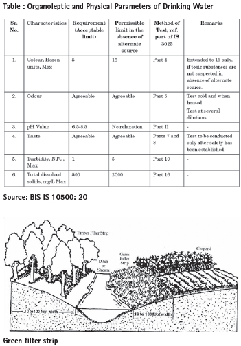
The water quality standards as prescribed by the Bureau of Indian Standard are tabulated below:
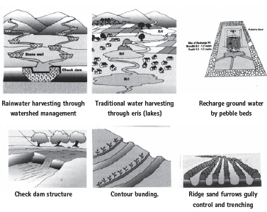
Rainwater harvesting
The term rainwater harvesting refers to collection and storage of natural precipitation and also other activities, aimed at harvesting surface and groundwater, prevention of losses through evaporation and seepage, and all other hydrological studies and engineering interventions, aimed at conservation and efficient utilization of the limited water endowment of a physiographic unit, such as a watershed.
The options for water harvesting are the following:
• Construction of storage structures for “in situ” collection of rainwater.
• Farm ponds for collection of runoff, either for supplemental irrigation or for augmentation of groundwater.
• Check dams for storing runoff in first order (small) streams.
• Percolation tanks at appropriate sites for augmentation of groundwater.
• Construction of ponds and reclamation/revitalization of traditional water arresting structures.
• Artificial recharge through wells.
• Reduction of evaporation from surface water bodies and soils.
• Prevention of seepage losses in appropriate situations.
• Enhancement of runoff through mechanical arid chemical treatment in catchment areas.
• Sub-surface dams to arrest base flow of groundwater.
• Soil and water conservation practices comprising contour and terrace bunding.
Groundwater recharge
The ‘Manual on Artificial Recharge of Groundwater’, prepared by Ministry of Water Resources, Central Ground Water Board (CGWB) gives the following options for artificial groundwater recharge:
1. Ditch and Furrow Method
2. Lateral Ditch Pattern
3. Dendritic Pattern
4. Contour Pattern
5. Spreading Basin or Percolation Tanks
6. Gully Plug / Check Dam / Nala Bund / Gabion Structures
7. Dug Well Recharge 8. Recharge Shafts / Pits / Trenches
9. Artificial Recharge through Injection Well
10. Induced Recharge from Surface Water Sources
11. Subsurface Dykes / Underground Bandharas
Rainwater harvesting and groundwater recharge should be dovetailed with watershed development programmes. This involves several actions as outlined below:
• Arresting groundwater decline and improving its accessibility water quality
• Preventing surface water run-off during monsoons
• Reducing water wastage and recycling of wastewater
Watershed management
The watershed management aims to conserve the natural drainage and flow of water stream. This involves development, conservation and revival of the ponds, check dams, water, gully control structures, contour bunding, ridges and furrows, rainwater harvesting micro-irrigation, etc.
Various options can be adopted according to topography and water quality of a watershed:
a. On-channel Storage and Recharge of Storm Water Channels: Several seasonal streams become activated during the monsoons providing the outlet to flood waters as well as local area runoff. With careful planning these waters can be stored on the channel itself. The storage capacity of channels can be enhanced by deepening and can he enlarged to form on-channel lakes at locations conductive to recharge. These reservoirs offer the possibility of creating rich urban bio-diversity habitats.
b. Off-channel Storage for Floodwaters: As all storm water cannot be stored on channel, possibilities exist for the creation of off-channel reservoirs linked to the main channel. The creation of off-channel reservoirs, especially wherever a suitable recharge area, exists in the neighbourhood of a channel, is a useful device for storing water for the lean season. These reservoirs also offer the possibility of creating rich urban bio-diversity habitats.
c. Storage in Lakes and Depressions: In urban areas, lakes have often been misused for dumping of solid waste and sewage disposal. The storage capacity of these can be increased by desilting and widening. The water quality would need to be improved by replicating the principles of wetlands by the systematic induction of aquatic plants and fish. This is a very low cost treatment and subsequently only clean water would enter the underlying aquifer.
d. Floodplain Reservoirs for Conjunctive Extraction: Very often the fresh water aquifers underline the floodplains. In urban areas, there is no place to store the monsoon discharge of the river due to lack of topographical relief. To overcome this difficulty simple reservoirs on the floodplain can be created by scooping out earth at appropriate locations and letting these reservoirs to be filled up by the expanded monsoon season flow of the river. Watershed management Urban ponds, water bodies and lakes are important part of the eco-system as they recharge groundwater, provide aesthetically pleasing space for recreational activities, prevent floods and allow sediment retention.
Based on natural topography, catchment zones should be identified. The parks and green strips can have bio-swales and recharging pits which receive water from all hard paved areas. The storm water flow into the de-silting chamber with grating, where the silt settles down and can be cleaned regularly. As the chamber has a grating over it, the other waste like leaves, etc. will not enter the drain. From the storm water drain, the water flows into a bio-swale (located in parks and green strips), and recharging pit.
Based on hydrology, geology, climate, ecological and socio-economic consideration, the watershed management strategy may be developed with the drainage and landscape. Fine-grained landscapes, with high drainage densities and high stream frequencies are necessary in areas with erodible soils and rocks and high rainfall.
River basin management
River basin management process entails the delineation of river basin, data, local knowledge, maps, land status, land management, land use, demographic, social, cultural, economic and environmental information. These are the basis of the diagnosis of the issues, problems and evolving the plans and strategies of river basin management. Comprehensive river basin planning involves sound economic analysis, environmental analysis and participation of the local people affected by the project.
River Zone (Zone O) in Delhi covers 9,700 Ha of land, most of which belongs to Delhi Development Authority/Government. However, it has been vulnerable to encroachments by 76 unauthorised colonies, besides development of IT Park/DMRC Depot, temples, Commonwealth Games Village, DTC Depots, transport infrastructure projects, etc. The most of the properties in 76 unauthorised colonies, the land largely belongs to the government. The Government in 2019 issued NCTD (Regularisation of Property Rights in Unauthorised Colonies) Regulations. Although this zone is not covered by this notification, there are pressures to exclude these unauthorised colonies from this zone (O). There are also gaps in land records and services. According to NCAER (2020) the status of land record and services is given below:
• Records of Rights : Poor, Obsolete
• Spatial Records : Very Poor, Manual
• Digitised Cadastral Maps : 53% of Villages
• Digital Registration Process : Very Poor
• Quality of Land Records, Updation and Land Use : Very Poor
Lack of digital Land Information System and practice of power of attorney are the major hurdles in land management. This needs the adoption of information communication technologies (ICT) based digital ledgers for data management, Land Admin Domain Model (LADM), geographic information system (GIS), electronic data capture, web-based applications, satellite/Total Station/Drone surveys, national spatial data infrastructure (NSDI) and e-governance.
For sustainable management of land in river basin in Delhi, the following initiatives are essential:
Digital Ledgers and Blockchain, A digital ledger is a geographically distributed database that is shared and synchronized across a network of the participants. It has a blockchain structure where the data is stored in blocks, linked and secured by cryptography for handling identities, contracts and assets. The blockchain is an electronic transactions system. It is based on a hash algorithm that converts data into a block.
There are three types of blockchain: public, consortium and private blockchain. A public blockchain allows anyone in a network to be involved in the process of adding blocks. A consortium blockchain requires participants to be from an organization. A private blockchain is operated by a particular organization. Every user receives a unique public key and a unique private key. These two keys can be used for privacy and authentication. Thus, a blockchain is a chain of digital signatures that are joined together in clusters with a specific block.
LADM framework
The Land Administration Domain Model (LADM) is an International Standard (IS) of the International Organisation for Standardization, as ISO 19152. It covers basic information related to components of land administration and includes agreements on administrative and spatial data, land rights and source documents (e.g. deeds or survey plans), and forms of tenures- customary tenure, government land, and privately held land.
As such, LADM is capable of depicting the Land Administration System and different forms of land grabbing. The LADM defines the Spatial Units and different forms of property (commonly held, public or private). It contains the Rights, Restrictions and Responsibilities. For land pooling two specialised classes, one for public based regulation (AL_ Infrastructure Reserve), and the other for a Land Registration, where the ownership rights and the publicly imposed restrictions are registered for each case.
This involves allocation of institutional responsibilities, building around shared values and a cross-sectoral management involving the departments of environment, forests and climate change, industry, transport, power, health, rural development, finance, pollution control, irrigation and flood control, local urban bodies, water supply and sewerage, etc. This implies developing a comprehensive policy and blockchains, governance reforms, pricing, water demand management, land use zoning and capacity development for planning, implementation, monitoring and enforcement.
Community participation
Regardless of formal regulations, local informal regulations are usually stronger in eco sensitive river basin, particularly with respect to water use, storage, pollution control and social audits. This poses certain implications. First, strengthening central regulatory agencies, who should not impose uniform standards. Local variations in regulation are legitimate. Second, the regulatory agencies should facilitate negotiations between communities and development by supplying reliable information on water, energy, irrigation, emissions and effluents, and local environmental conditions, providing technical advice, and transferring experiences from other locations.
Rather than sticking to the conventional path all the time, some flexibility must be retained to learn lessons and build on from there. Pro-environment and pro-development objectives of a river basin have to be met in a dynamic situation where many things cannot be taken for granted and the process is transparent.
Sustainable water management
It is necessary to understand that ‘sustainability’ is primarily a process and then an objective. This involves:
• Better understanding of ecosystem, river basin management, digital surveys and planning
• Stronger local governance to address local issues, poverty and culture.
• Creating public-private partnerships and a financial/business model at local levels.
• Moving away from goal oriented approach to process based approach.
• Increased capacity building, decentralization and better departmental co-ordination; decrease in top down methods.
• Increased stakeholder involvement across levels, disciplines and strata; decrease in experts only approach.
It is necessary to map the socio-cultural activities, festivals and cultural resources which are dependent upon the river. It is also essential to assess dependency of riparian communities on riverine resources and their perception towards river biodiversity and conservation. The local people should be helped to deter illegal construction, sand mining and fishing and learn about their river and its ecology.
Conclusions
Rivers have nurtured numerous civilizations through the ages and are part of India’s history. The river is a vehicle for human emotions, elation and melancholy. This gives the river a symbolic motif in art or literature. The landscape of hills, cascading tributaries and rivers articulate a poetry of space and a celebration of the kinaesthetic and topographic abstraction of nature. A meandering river along the hills and forests manifests commonality and interdependence.
However, with the changing times, the rivers are seen more as the sources of economic growth and material needs. People are no more connected with the river. The river floodplain is becoming the ground for real estate development. This is inviting an ecological disaster. Indiscriminate damming of the river flow, water extraction and canalisation, dumping of solid and liquid wastes, sewage/wastewater and industrial effluent discharge in the rivers have seriously jeopardised their ecological sustainability.
Undeniably, a judicious integration of ecological, scientific research, digital planning and management is necessary to keep the urban rivers clean and flowing. This requires committed participation of the local communities. The cultural and traditional connect with water, as reflected in traditional water structures, and purification customs, can be potential social tools to involve the masses to conserve water resources and to prevent pollution of rivers.
References
Acciavati, Anthony, 2015, Ganges Water Machine—Constructing a Dynamic Atlas of the Ganga River Basin Applied Research + Design Publishing, San Francisco, USA.
Amir, Sheeba and Ashim Manna, 2017, The Landscape of Water Access, My Liveable City, October-December
CSE, 1997, Dying Wisdom: Rise, Fall and Potential of India’s Traditional Water Harvesting Systems, New Delhi.
CSE, 2001, Making Water Everybody’s Business: Practice and Policy of Water Harvesting, Eds. Anil Agarwal, Sunita Narain and Indira Khurana, New Delhi.
Central Public Health and Environmental Engineering Organisation, 2014, Urban Water Supply and Sanitation, Ministry of Urban Development & Poverty Alleviation, New Delhi.
CPHEEO, 1993, Manual on sewerage and sewerage treatment, 2nd edition, Central Public Health and Environment Engineering Organisation, New Delhi.
Clay, Grady, 1979, Water and the Landscape, McGraw. Hill, New York.
Central Pollution Control Board 2018, Reports on Water Pollution in India, New Delhi.
CPCB, 2000, Status of water supply and wastewater generation, collection, treatment and disposal in class I cities, CUPS/44/1999-2000, Central Pollution Control Board, New Delhi.
CPCB, 2000, Status of water supply and wastewater generation, collection, treatment and disposal in class II towns, CUPS/49/1999-2000, Central Pollution Control Board, New Delhi.
Central Pollution Control Board, 2001, Constructed Wetlands for Wastewater Treatment, New Delhi.
Delhi Development Authority, 2010, Zonal Plan of Zone ‘O’ (River Yamuna Zone), New Delhi
DDA, 2007, Master Plan for Delhi-2021, New Delhi.
DUAC/Amit Ghosal, 2016, Punjabi Bagh , Ward 103, New Delhi
Indian Water Resources Society, 1996, Theme Paper on Inter-basin Transfer of Water for National Development – Problems and Prospects, New Delhi. Institute for Human Development., 2000, India Water Vision 2025, Report of the Vision Development Consultation, New Delhi.
INTACH, 2015, Ecological Inventory of Yamuna River in Delhi, INTACH, New Delhi.
INTACH, 2015, Naturalising Delhi: A Plan for Enhancing climate Resilience, Urban Biodiversity and Habitat, Natural Heritage Division, INTACH, New Delhi.
Jain, A. K., 2021, Environment, Urbanisation and Development, Discovery Publishing House, New Delhi
Jain, A.K., 2009, Low Carbon Cities-Policies, Planning and Practice, Discovery Publishing House, New Delhi
Jain A.K., 2015, Smart Cities—Vision and Action, Discovery Publishing House, New Delhi
Jain A.K., 2016, Regeneration of Rivers and Water Bodies, Discovery Publishing House, New Delhi
Jain A.K., 2011, Making Infrastructure Work, Discovery Publishing House, New Delhi
Ministry of Water Resource, 1999, Integrated Water Resource Development: A Plan for Action, Report of National Commission for Integrated Water Resource Development, Government of India, Vol-1, New Delhi.
MoUD, 2012, Improving Urban Water Supply & Sanitation Services, Advisory Note, Ministry of Urban Development, Government of India, New Delhi
Ministry of Housing and Urban Affairs, 2014, Swachh Bharat (Clean India) Campaign, Government of India, New Delhi.
National Council of Applied Economic Research, 1996, The India Infrastructure Report- Policy Imperative for Growth and Welfare: Expert Group on the Commercialisation of Infrastructure Report. NCAER, New Delhi.
NEERI, 2005, Study on Rejuvenation and Environment Management of River Yamuna in Delhi, Unpublished Report for Delhi Development Authority, New Delhi
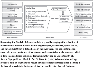
Styczynski, A. Wold, J. Tah, S. Bose, A., 2014, When decision making processes fail: an argument for robust climate adaptation strategies for planning in the face of uncertainty, Environment Systems and Decision Journal, Springer.
World Bank & Central Groundwater Board, 1999, India: Water Resource Management, Allied Publishers, New Delhi World Bank, 1998. India Water Resources Management – Urban Water Supply and Sanitation Report, Washington, DC.
Yes Bank, 2015, The Ganga Basin: Outthink Pollution and its Importance, New Delhi


 (No Ratings Yet)


Leave your response!