| Positioning | |
KOPOS – Kosovo Positioning System
KOPOS system provides opportunities for carrying out unified, highly accurate, efficient and long-term sustainable measurements in the future |
 |
|
 |
|
 |
|
The set of satellite systems for global navigation that are functioning or are expected to be launched in the future, in English are called GNSS (Global Navigation Satellite Systems), whereas in Albanian it will be SSNG (Sistemi satelitor për navigim global). This system allows determining the position in the whole globe with an accuracy of two or three meters by even using simple equipments [DMA, 1991], [Farrell & Barth., 1999]. The possibility of civil use of these military systems has led to pioneering development in traffic enforcement, logistics, construction industry, tourism and many other technical fields and beyond that.
Some of these systems have been listed below:
– American global positioning system (GPS)
Launched 1978, this system was fully configured in 1994, whereas from January 2009 it has in total 32 GPS satellites. These satellites emit radio waves: L1, L2, (L5) that are carriers of frequencies; C/A and since 2005 civil codes L2, and after 2012 civil codes L3C; P code in frequencies L1 and L2.

– GLONASS, Russian global navigation satellite system
This system was launched in 1982, but its full configuration has not yet been done, whereas from January 2009 it has in total 17 satellites in use. GLONASS satellites emit radio waves: L1, L2 that are carriers of frequencies, codes L1 and L2 C/A, then L1 and L2 P-codes.
– European system GALILEO
This system was launched in 2006, its full configuration and usage is expected in 2015. The satellites of GALILEO system emit radio waves L1, E1, E2, E5 and signals E6.
While using L2C and L3C, it is possible to determine ionosphere parameters. Therefore, the aim is to have a precise geodetic positioning without differential positioning techniques. L2C frequency carriers have better quality then L1, while allowing better tracking of low satellites. L5 is designed in such a way that it would be least affected by effects of many trajectories.
Nowadays, these systems work independently from one another. The user works with one of these systems depending on the receiver selected. The American GPS system currently is used in most of cases. In geodetic applications, more and more receivers that can elaborate signals from GPS and GLONASS are used. In Europe, the European Geostationary Navigation Overlay Service (EGNOS) complements the GPS system with additional satellites, which leads to improved accuracy and reliability of measurement of the position in Europe. This is considered an advantage and cooperation between GPS and GALILEO systems.
Since the GALILEO system is multidimensional, it will play an important role in future applications.
In communicating with satellites in the space, the receivers determine the positions of the objects where they are fixed. The receivers should communicate with at least four satellites in the space for determining (calculating) its position. The accuracy and reliability of the GNSS systems, which are currently available, have restrictions (limitations) in presenting the common accuracy of GPS for civil works up to +1 – + 3 meters.
This technology with its new access has created the idea for modeling all errors (bugs), such as: time determination and errors in orbit, obstruction of satellite signals in their way through ionosphere and troposphere up to the point where the GNSS receiver is located for determining the correction of the observed data over unknown points.
The responsibilities of Kosovo Cadastral Agency regarding national network are foreseen by Law on Cadastre, [Law No. 04/-L-013]. These responsibilities start from the maintenance of referent network up to the maintenance of cadastral map, cadastral measurements and protection of cadastral boundary signs. Digital cadastre as a vision, but not to remain only a vision [Steudler 2006] is clearly being implemented from Kosovo Cadastral Agency for collecting and processing cadastral data in the framework of NSDI (National Spatial Data Infrastructure). All the measurements from now on, if there are no physical obstacles will be supported by KOPOS as a general and permanent national referent GNSS system.
Regular maintenance and development of cadastre will be always based on the main geodetic state network. After 1999, KCA began consolidating cadastre in Kosovo, the main task being observation of the state geodetic reference network. After observing and analysis, it has been concluded that the activity should begin with stabilization adjustment of the points in the field as a base for starting cadastre maintenance and its further development.
The principle of setting the position
GNSS technology, while receiving signals from satellites, calculates the distance based on the time differences. These distances are calculated from the moment it is transmitted up to the moment of receiving the signal. If the distances of three different satellites are known, it is possible that through spatial intersection (geodetic intersection) one can determine the antenna position in 3D (X, Y, Z) in relation to the satellites.
Such intersections doesn’t provide real distance measurements because the satellite and receiver time are not harmonized, therefore the measured distances are not real distances, but are called pseudo distances. To avoid this, it is necessary during measurements to have at least four pseudo distances for calculating four unknowns (X, Y, Z, ΔT), where time factor as a fourth dimension is also included.
The accuracy and reliability of the GNSS systems, currently available, are limited mainly from:
• Ionosphere and troposphere influences
• Uncertainties in the predicted orbits of satellites
Incorporation of network KOSOVAREF01 into KOPOS
Damage of Triangulation Network, the period before 2000, and creation of new circumstances for geodesy raised the idea for developing new state geodetic network. Here, the report of the Bessel ellipsoid and other ellipsoids in the plane [Meha, 1998] should be analyzed beforehand. Therefore, the stabilization and measurement of the new geodetic network points, using GPS technology, started in 2001. First order reference network was created by 32 basic points distributed homogeneously throughout the territory of the Republic of Kosovo, while network densification was made with the second order network points a year later.
KOSOVAREF01 Coordinate System was based on the EUREF. Geodetic Datum is defined by Gauss-Krüger Projection in Terrestrial European System ETRS89 (GRS80 Ellipsoid). As a result, there is the WGS84 Coordinate System, which is based on Ellipsoid dimension, in rotation angle of Earth’s rotation, and in light speed as well as constant parameters defined by US Department of Defense (DoD), as a reference frame for establishment and maintenance of GPS System.
Dimensions of Reference Ellipsoid WGS84, as accepted by the Geodetic Reference System 1980 (GRS80), are:
a = 6 378 137 + 2 m
1/f = 298.257223563
These dimensions are used for calculating geodetic measurement. Coordinates axels (XYZ) in ETRS system, are fixed in the centre of earth, where Z axel goes across North Pole, and X & Y axels lie in equator plate.
Estimates suggest that when it comes to Europe, coordinates accuracy of the points set by ETRF`89 is roughly +2cm, whereas for WGS84 calculated error of coordinates is roughly +10cm.
The Kosovo geodetic datum [Meha, 2005a, 2005b] is defined as follows:
– Reference spheroid: IUGG (International Union of Geodesy and Geophysics) ellipsoid GRS80 (Geodetic Reference System of 1980)
– Reference system: ETRS89 (European Terrestrial Reference System)
– Origin of coordinate system in the intersection point of projections of the central meridian 210 with Equator
– Origin of height: Sea Level
– Projection: Gauss-Krüger transversal cylindrical projection, conform (7th zone)
– Central meridian (210) with scale reduction 0.0001 (scale factor 0.9999)
The new system Kosovaref01 covers the whole Kosovo territory, where there are established or created 32 geodetic points of the Ist order and 452 points of the IInd order. These points are established as a base for cadastral and other geodetic measurements. Therefore, stabilization of permanent referent GNSS network (KOPOS, has a priority for high accuracy geodetic measurements, but it also contributes in modeling atmospheric parameters (troposphere and ionosphere), for weather and earthquakes forecasts. Speaking in financial terms, the project in the future shall lower workrelated costs and shall, at the same time, generate revenues for its maintenance, but it does not guarantee (learned from others experiences) that the system could be maintained only from revenues.
Establishment of permanent reference stations
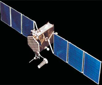
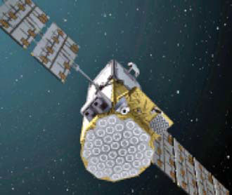
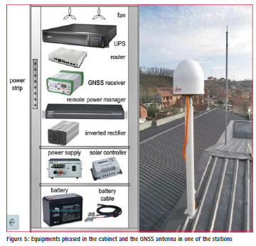
The well known producer of surveying equipments ‘Leica Geosystems’ from Switzerland, after an international competitive process was the winner of the contract funded by World Bank for stabilizing eight permanent reference stations of KOPOS.
The new KOPOS network has used the most advanced technology and will be the first GNSS network in the world that has used the newest receiver Leica GR25, which has been publically presented for the first time in the equipment and geodetic instrument trade fair – INTERGEO, 2011 in Germany.
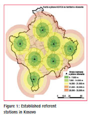
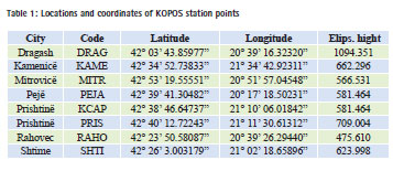
Kosovo Cadastral Agency, together with Leica experts and local experts, and also supported from GIZ (Germany) experts, have realized fully the study, establishment of referent points and testing of KOPOS system. In figure (1), the permanent station can be seen – points which cover the territory of the Republic of Kosovo. Whereas in the table (1), it is presents the geographic position of the permanent GNSS stations. The system is designed also for eventual incorporation of reference stations from neighbor countries: MONTEPOS Montenegro, ALBPOS Albania, MAKPOS Macedonia and AGROS Serbia.
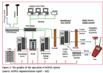
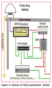
The monitoring and maintenance of permanent GNSS stations is carried out from the control centre. The operation of the system, while including the permanent stations, control centre and users, is presented in figure 2.
Some technical characteristics of KOPOS
Equipment established in permanent stations are:
– GNSS antenna AR25 (choke ring antenna) protected from different atmospheric conditions, suitable for receiving all satellite signals currently in use, and those foreseen for later usage;
– GR15 multi frequencies receiver with a sufficient number of channels, for accepting all signals currently available and those for future;
– VPS network ruter, and the necessary connection with ADSL cable;
– Constant power supply (48 hours, backup); and
– Cable, box for setting the device, the material for installation, etc.
The antenna is installed on a pipe so that it is mechanically stable. Location security is guaranteed by the effects of wind, vibration, shaking, lightning according to local standards, etc.
GNSS antenna (choke ring – the last word of the technology) is used as an antenna for reference stations. Antenna phase center is determined though an individual absolute calibration.
Antenna and the receiver must be able to receive all signals available from GPS and GLONASS systems and also GALILEO-s after it will be functional.
KOPOS services –RTK and RINEX data
Acceptance of correction data in real time (RTK) and RINEX data (post-processing) from KOPOS system is done in different ways.
Users of (RTK) products in real time could accept the corrected data in real time through internet (GPRS), or if it is needed also through GSM since KOPOS offers this possibility as well. The format of the data flow should fulfill the RTCM specifications:
− RTCM 2.3 for FKP- and VRS data (guarantee for compatibility from the highest point to the lowest point for the oldest devices)
− RTCM 3.1 for FKP-, VRS and MAC
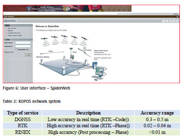
Clients of RINEX products (postprocessing) can download the data from selected referent stations in RINEX format (all formats up to the v 3.0) for a time period selected from the past. For this, the interface page for users based on the web (kopos.rks-gov.net) are available in Albanian, English and Serbian languages, through which users can download all the requested data independently. Except downloading the RINEX data, the system enables also the post processing and adjustments of static measurements. The results of data post processing and adjustment could be taken electronically (e-mail).
Accuracies expected from KOPOS network system are listed in Table 2:
SpiderWeb SBC (Spider Business Centre) program is in use for administration of the registered users, prepaid services, to search RTK usage and RINEX data, invoicing, informing of users on real time regarding the operation of the system, etc.
Benefits from KOPOS system services
The benefits from KOPOS system are different, but at the same time a creative approach in the field of geodesy for its usage in public and private sector is required, since this system enables the establishment of reliability and accuracy for geo-spatial data in terms of quality.
For this reason, cooperation of local experts with international associations in relation to this field is required. Some of the creative engagements, but also as requirements are presented below:
– To maintain and develop state coordinates referent system together with respective geodetic infrastructure;
– To provide access in geodetic data, in services and web based information;
– To closely cooperate with international geodetic associations;
– To provide geodetic and GNSS services for public and private sector;
– To develop awareness campaign for applicable services in high accuracy positioning; and
– To promote and advance geodesy science also through science wider community to support the government in developing the Land Administration and Management policies;
The usage of KOPOS system will support cadastral institutions, together with licensed private companies in implementing the cadastre projects in achieving the goal of heaving sustainable and stable digital cadastre [Meha, 2003].
Other economic benefits from KOPOS in the fields of geodesy, cadastre and spatial data as part of NSDI are:
– The usage of modern technology for measurements such as GNSS, digital photogrametry, aerial images and satellite images have been simplified and accelerated. In general, this approach leads to the influence in cost reduction for, e.g., surveying activities, property identification, monitoring, etc.;
– The accuracy and reliability of cadastral measurements is increased in the whole country, because KOPOS system is a unified system for the whole Kosovo territory;
– The expenses will be 8-10 times lower than the establishment and maintenance of third order reference network; and
– MCOs in Kosovo will have the opportunity to use modern GNSS rover for cadastral surveying and other geodetic works as well, etc.
The usage of GNSS system anywhere in the world has multidimensional benefits in terms of time, financial aspect, accuracy, security, etc. The fields where the system could be used are presented below:
– Geodetic measurements (cadastre, mapping, photogrametry, etc.)
– GIS
– Traffic management (land and air)
– Water management
– Emergent services
– Rail and sea transport (if the state has access to big lakes, sea, ocean)
– Public transport now and in the future (bus, trolley bus, tram, taxi etc.)
– Transportation of hazardous materials
– Vehicles navigation
– Tourism (database, maps, navigation)
– Forestry, Fisheries etc.
– Disaster management
– Inventory and valuation of immovable properties
– Urban Planning, Spatial Planning and Environmental studies
– Monitoring of engineering structures (dams, etc.)
– Environment protection
– Many other services related to the requests of society, institutors and private sector.
“The future satellite navigation systems will use improved technology and concepts, while helping the increase of usage quality and enabling to implement new navigation services for ‘smart’ vehicles, agricultural tools, ‘smart’ weapons, unmanned aircraft, mobile robots and other different advanced applications” (Farrell 2008).
The usage of measurements methods supported from GNSS now enables accelerating the work of local measurements significantly, as well as significantly reducing costs. The usage of system that now is continuously operational is a step forward in accelerating and simplifying the works and measurements in the field.
The data available should be used in a comprehensive manner, in order that the exchange of geographic data between central, local and international institutions, from INSPIRE point of view, will be significantly improved. With this, the bases for all geo-information technologies in the whole state have been established; in the field of cartography, cadastre, engineering, surveying, infrastructure, planning, environment, transport, e-governance, e-municipality, e-commercial, etc. Hundreds of users across the country will work without needing control referent points, which will increase enormously the efficiency of the work.
Conclusion
KOPOS system in Republic of Kosovo is a unified state reference network which offers in the real-time positioning accuracy in horizontal plane + 2cm and in vertical plane + 4 cm. GNSS system is the latest word of the technology for geodetic measurements, which is used in developed countries. Now as part of the GNSS family is also KOPOS referent network. This system offers the possibility to use the latest technology for geodetic measurements for every surveyor in Republic of Kosovo. GNSS has raised the level of accuracy and reliability of geodetic measurements, because it is a globally extended, secure and with the usage possibility of (American) GPS, (Russian) GLONASS and (European in the future) GALILEO.
Economic approach in geodesy is mainly oriented in harmonizing three components: high accuracy measurement, full reliability in measurements and lowest costs for collection geoinformation data. KOPOS system in Kosovo meets these three components, and as such will be 24/7 functional, under supervision of control center located in Kosovo Cadastral Agency.
References
1. DMA, 1991: Department of Defense World Geodetic System 1984, DMA.TR 8350.2, second edition, 1 September.
2. Farrell, A.J., Barth, M. 1999. The Global Positioning and Inertial Navigation. McGraw- Hill, New York 1999.
3. Farrell, A.J. 2008: Aided Navigation GPS with high rate Sensors. 2008 New York: Mc. Graw-Hill.
4. Law on Cadastre, Law No. 04/- L-013, Prishtinë 2011.
5. Meha, M. (1998).:Analiza e aproksimimit të elipsoidit ose sferës në rrafsh dhe saktësia e tyre. Buletini No 12. i FSHMN. Prishtinë.
6. Meha, M 2003.: The future and development challenges of sustainable cadastre and digital cadastre of Kosovo. 2nd Cadastral Congress, September 19-21,2003. Krakow, Poland.
7. Meha, M. 2005a.: KOSOVAREF01, EUREF Symposium held in Vienna, Austria 1-4 Jun 2005.
8. Meha, M. 2005b.: Analysis of permanent GPS reference station in Kosova. Symposium organized on the occasion of the 40 anniversary of the Faculty of Civil Engineering and Architecture. Pristine 2005.
9. Meha, M. 2006.:KOSOVAREF01, Libër, Botues Agjencioni Kadastral i Kosovës.
10. Meha, M., Çaka, M. 2011. Perspective of permanent referent network “KOPOS” in Kosova. INGEO2011, 5th International Conference on Engineering Surveying, September 22-24, 2011, Brijuni, Croatia. FIG commission 6. reviewed published papers p.143-150 . http://web.svf. stuba.sk/kat/GDE/Ingeo2011
11. National Imagery and Mapping Agency. 1997. Department of Defense World Geodetic System 1984: Its Definition and Relationships with Local Geodetic Systems. NIMA TR8350.2 Third Edition 4 July 1997.
12. National Imagery and Mapping Agency. Guidelines for Cadastral Surveying using, Global Navigation Satellite Systems (GNSS). Section 12 . 2003, First Published by Surveyor- General, Victoria, prepared by RMIT University. http://www.icsm.gov.au.
13. Steudler D. 2006. Cadastre 2014 – Still a vision? Switzerland. The paper was presented at FIG Working Week 2013, Abuja, Nigeria, 6-10 May 2013


 (4 votes, average: 2.50 out of 5)


Leave your response!