| GIS | |
Fuzzy logic approach for sustainable land use planning
Novaline Jacob and Krishnan R
|
||||
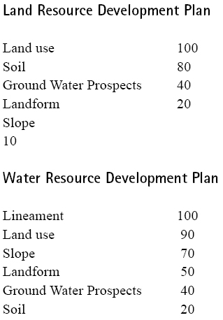
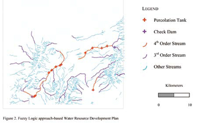
ImplementationThe model was implemented using ARC/INFO GIS software. Arc Macro Language was used to program. Two problems were addressed: 1) Generation of Land Resource Action Plan 2) Generation of Water Resource Action Plan. Land Suitability Analysis adopting fuzzy logic was done for ten land use classes, which were transformed into ten objectives. They include Silvipasture, Agroforestry, Forest Gap plantation, Fuel and fodder wood species, Hortipasture, Agro-horticulture, Forest enrichment, Forest protection & conservation, Horticulture and Dune Stabilization. Five terrain-related criteria namely, existing land use, soil, groundwater prospects, landform and slope were used and were analyzed within the AHP framework and were given importance in the order listed. As one has to suggest suitable sites for water harvesting structures like check dams, percolation ponds, farm ponds, gully plugs for arresting soil erosion etc, the problem tends to be multi-objective as in the case of land resource action plan. So this also can be formulated using fuzzy suitability rating method. There were four objectives i.e finding suitable sites for percolation tank, check dam, gully plug and stop dam. Six terrain-related criteria namely, presence of lineaments, existing land use, slope, landform, ground water prospects and soil were used and given importance in the order listed. For land resource development plan generation, existing land use was given higher importance, because the new land use that would be suggested, should be similar to the existing land use as people might not accept total deviation from existing land use. Soil was given next preference, as the soil conditions should support the new land use, followed by groundwater prospects, landform and slope. Whereas, for water resource development plan generation, lineaments were given higher importance, to facilitate water percolation so that groundwater is recharged. Land use was given next preference, as the developed water resource would be utilized for the land use class, which requires increased water supply. This is followed by slope and landform, which offer varying degrees of terrain restrictions for water harvesting structures. And also, water harvesting structures become essential wherever groundwater prospects are poor. Soil is being given the least preference as its effective depth is negligible and therefore its influence on site suitability for water harvesting structures is less. Modeling was done in raster environment. Vector data layers corresponding to various themes like land use, soil, groundwater prospects, landform, slope, lineament for a part of desert-prone district in Rajathan were used in the model. The importance values assigned to the parameters become the ß values in the distance equation (1). Decision Rules were framed by the resource experts for each objective (table-1). Highest suitability pattern vector (S1) represents ideal terrain conditions and always takes the highest value of 100. Terrain conditions represented by next highest suitability pattern vector S2, takes a value of 80 and so on and the Lowest suitability pattern vector S5, takes a value of 20. Terrain conditions in each cell (Area vector) were checked against the Ideal terrain conditions (Highest Suitability Pattern vector in table-1) for each objective and distance between these two vectors were found. The cell is assigned to that land use class for which the distance is closest, and therefore the membership grade is highest. Other membership grades for each cell is preserved in the database for finding the second best suitable land use or third best suitable land use. Therefore, one could get first best alternative, second best alternative etc. and there by generate different scenarios. Second best and third best alternatives become important when there is more competition for the first best alternative, which in turn would bring down its demand. ConclusionConventional land assessment techniques are hampered by the inherent constraint of classical set theory that does not allow for partial set membership conditions and imprecise information. Consequently, one’s ability to use GIS, with conventional techniques, is severely limited. In contrast, fuzzy techniques are shown to reduce information loss by obtaining membership grades for each land suitability class. Such information allows identification of the extent to which a particular area belongs to a land cover class. It is also possible to use the stored fuzzy membership grades for database queries like. – Find the second most suitable land use/crop for a particular area List all the areas, which are suitable for both agro-forestry and horticulture and find the suitability value. – List all the areas, which are suitable for agro-forestry or horticulture and find the suitability value. Achieving greater balance between land use and land conditions should become more feasible through implementation of the methodology described here |
||||


 (No Ratings Yet)


Leave your response!