| Applications | |
Fast approach cadastral documentation
The logical consequence of economic development–land consumption–substantiates the need for sustainable land management and cadastre |
 |
|
Taking into account the various experiences of land management in developing, transitional, or developed countries the results are sobering: the main goals often could not be reached and the respective laws failed under implementation. The relevant discussions for renewal or development of law bodies ask for
– more powerful implementing governmental institutions,
– more transparency and monitoring on all levels of implementation,
– more rigorous interpretations of the existing laws, and a
– faster actualization of the documentation systems as a base for work.
Looking to Table 1-1 even with a land use planning and land management system that did not fulfill all of its tasks, at least coordination with services and care by utilities could be achieved to a very great extent. Service quality in developed countries such as Switzerland is high and the investments by utilities are worthwhile. In countries with random growth settlements the supply of utilities such as waste disposal, water, sewage and communication often is weak.
Table 1-1 Comparison of development stage, land management laws, sprawl and service quality.
The key question remains: How to achieve land management in a dynamic environment taking into account economic development, need for rising food and fiber production as well as preserving production capabilities and preventing land degradation? How to plan and manage all uses of land in an integrated manner such that land management becomes sustainable and supports wellbeing and good governance? – A possible approach shows the following truths:
Statement 1: Economic development consumes land.
Statement 2: (Sub-)Urban development sprawls on agricultural land.
Statement 3: Land consumption and sprawl cannot be stopped but guided and controlled.
Statement 4: Guidance of land consumption and sustainable land management (SLM) creates better conditions for development.
Statement 5: Sustainable land management (SLM) needs cadastre as a pre-requisite.
Economic development consumes land
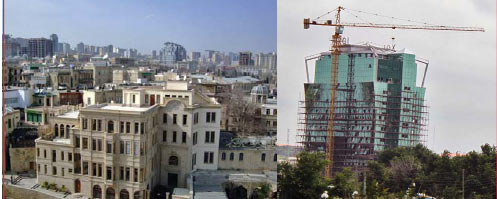
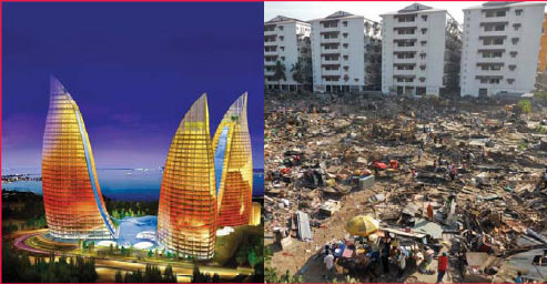
As a basic rule it must be accepted that economic growth leads to the demand for land. This happens in agricultural-based as well as industrial economies. By 2009 economic growth in Switzerland resulted in one square meter of land (agricultural ~) being consumed by streets and buildings every second. With a well defined and permanently monitored land use planning system in place the consumption of land could not be hampered. Several towns had to integrate formerly independent villages as suburbs. Equal results can be found in the megacity of Baku, Azerbaijan and Accra, Ghana. There development combined with migration from the land produced a phenomenal construction boom (Figure 2-1).
Figure 2-1 Construction hype in Azerbaijan (2008, left) and Ghana, Accra (2011, right).
(Sub-) urban development sprawls on agricultural land
On all continents, a relative decline in average urban growth rates has been observed for the last 20 or 30 years, compared to those of the preceding decades. This declining trend in demographic growth becomes more obvious if fixed perimeters are used, as a general process of spatial expansion is being seen everywhere. The advancement of urban sprawl along communication routes often precedes the type of sprawl where the empty areas are filled.
Aside from these general forms of urban sprawl, the patterns of peripheral expansion turn out to be very varied in terms of type of housing conditions, population pattern, means of protecting structures, construction type, and social categories. Despite geographical, socio-cultural and political situations differing greatly from one metropolitan area to another, the processes of urban expansion are similar.
In metropolitan areas of developing or post-conflict countries, the informal urbanization of the outskirts is a classic working-class practice. This happens in the form of clandestine housing developments that fail to comply with the planning regulations, or in the form of illegal occupation of sites without the owners consent, with inhabitants constructing their own, often precarious, dwellings. This illegal occupation (e.g. Kosovo (UNCESCR 2008), invasiones in Latin America, squats or squatter settlements in Asia, campements in Africa) develops preferentially on available sites on the city outskirts, often unsuitable for habitation, it may equally occur within the gaps in the urban area, including in central or peri-central zones.
According to Boret (2004) the centrifugal dynamics by no means affect only the poorer people and working classes, who are pushed towards increasingly offcentre locations. A dispersal of well-off households across the outer peripheral area is also in progress, facilitated, of course, by the rapid growth in car ownership. This oddity occurs as well in metropolitan areas in developing countries. Luxury apartments in Cairo, a long way from the city centre, the construction of vast luxury residential blocks of very low density in Sao Paulo, and luxury residential districts in Delhi rural fringes are illustrations of this phenomenon.
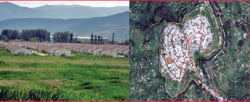
Figure 3-1 Sprawl as a planned development for IDP’s Gardabani nearGori, Georgia (left) or Gihembe IDP camp, Rwanda (right).
The dispersal of city dwellers is, in some cases, driven by the search for a better living environment, which translates into a process of urban people populating the rural areas around the city. This is illustrated by the proliferation of datchas in the countryside and forests around Moscow, the conversion of farmhouses in the south of Delhi, or the conjuntos cerrados (secure residential blocks, gated communities) that are multiplying around the village centers in the Sabana to the north of Bogota.
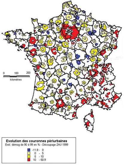
In large metropolitan areas in industrialized nations, the phenomena of remote and discontinuous urban extension, linked to increased car use and home ownership, has also been commonly observed in France (Figure 3.2). The American metropolitan areas bring this phenomenon to its climax.
Figure 3-2 Evolution of sprawl in French urbanizedareas from 1990 to 1999 (Guiet, Y. 2004).
Urban development is related to the income situation of people. Prud’homme (2004) stipulates a direct link between the size of a city and per capita income. As a logical conclusion it can be stated that higher income people tend to realize the desire for single family housing” (Boret, D. 2004). Households moving to the by realizing unused construction zones through legal force is under intensive discussion (Bertschi, M. 2002 and Eggenberger, M., Stettler D. 2008). Agricultural land in industrial countries is decreasing because of compensation for construction in forests or protected areas. In central Europe where rigid forest protection acts are in place, a further loss of agricultural land is the consequence.outskirts of cities can be explained initially by the available property found there. In effect, going with improvements in transport people are always looking farther away for less expensive property. This factor, combined with a strong desire for property ownership, the role of accommodation as a social mirror, and the favorable image of single-family houses within our societies, strongly influences households’ “desires” regarding housing type. The housing in dense districts against all planning efforts is less attractive. In an analogous way all over the world the new form of housing in gated communities is asking for more land in the outskirts of cities. Due to these facts it can be concluded that there is a strong sociologically driven force that causes sprawl.
Sprawl may also result from planned development, as demonstrated by detached housing developments and other residential programs produced by the capital investment sector or controlled by the public sector. Some projects may be on a very large scale: new districts corresponding to satellite sub-cities in Delhi, huge metropolitan projects in Bangkok, edge cities in Cairo, re-settlements of IDP’s in Ramana (Baku, Azerbaijan), Gardabani (Gori, Georgia, Figure 3-1), or Gihembe (Rwanda, Figure 3-1), etc..
In industrialized countries construction zones were extended on repeated occasions or periodically as a stimulant for the development of municipalities. The land market dried up although the existing construction zones are filled only to 75% capacity. In Switzerland up to 25% of the areas still are not under construction due to land stockpiling or difficult ownership conditions. Therefore increasing density by realizing unused construction zones through legal force is under intensive discussion (Bertschi, M. 2002 and Eggenberger, M., Stettler D. 2008).
Agricultural land in industrial countries is decreasing because of compensation for construction in forests or protected areas. In central Europe where rigid forest protection acts are in place, a further loss of agricultural land is the consequence.
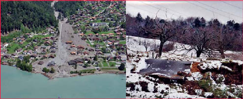
Figure 4-1 Debris fl ow in the Bernese Alps, municipality of Brienz (2005,left), Switzerland and landslip in the eastern Jura Mountains, municipalityof Wintersingen near Basel, Switzerland (1999, right).
Land consumption and sprawl cannot be stopped but guided and controlled
The sustainable treatment of land as a finite resource today is a mayor goal of space-oriented activities. Against the background and the requirements of a growing population the World Bank defined its sustainable land management (SLM) in 2006 as a knowledge-based procedure that helps integrate land, water, biodiversity, and environmental management to meet rising food and fiber demands. This should be achieved by sustaining ecosystem services (Ecosystem services are the benefits people obtain from ecosystems. These include: – Provisioning services that provide necessities such as food, water, timber, and fiber; – Regulating services that affect climate, foods, disease, wastes, and water quality; – Cultural services that provide recreational, aesthetic, and spiritual benefits; – Supporting services such as soil formation, photosynthesis, and nutrient cycling. Source: Millennium Ecosystem Assessment 2005.) and livelihoods. This definition mainly is focused on agriculture and rural development. When it comes to urbanized areas the water, environmental, and biodiversity aspects may have priority.
Figure 5-1 Urban investment project in Baku, Azerbaijan – Flame Towers, under construction(2008 – 2013, left) and urban development with evictions in Borei Keila, Cambodia (2012, right).
Bearing in mind Prud’homme (2004) the city itself, based on its economic role as a flywheel, is the moving force for sprawl. In cases where land use planning is in place sprawl happens in a periodical ow after extensions of construction zones (e.g. planning cycles of 10-15 years in Switzerland). The pressure to repopulate the outskirts by legally approved zoning is mainly dependant on economic reasons, as mentioned above. These processes are guided by risk based land use planning or prioritized public interest. Overall total stagnation seldom happens because economic pressure is strong enough. In non-industrial countries economic pressure often is overwhelming and dynamic so even guidance and control do not happen if the relevant instruments are not in place (see Table 1-1). Land consumption, however, declines right away if the economy shows signs of weakness.
Direction is successful especially if there is danger to be avoided by risk based land use planning measures. Hazardous areas such as floodplains, mud and snow slide areas etc. (Figure 4-1) are not feasible conditions for housing (Kohli, A. 1999). Even belated identification can be the reason for resettlement (In the Swiss Canton of Nidwalden, Municipality of Oberdorf the destruction of a training center Hostetten-Wil was ordered due to the danger of flooding. Measures for damage prevention would have been disproportional. In future this area is restricted area for construction.) or restricted areas. In such cases active land use planning becomes SLM and is an asset for the community by increasing security of life and of investments as well.
Guidance of land consumption and sustainable land management create better conditions for development
By applying strong SLM procedures including transparent land consolidation methods to rural and urbanized areas, amongst other things, investments in utilities become highly worthwhile and create more favorable effects than in sprawled areas. Efficiency rates increase and network planning for water or sewage make sense. Site developments as well may profit from available and easily connected utilities, as these effects can be realized by first agglomerating construction in abandoned areas, industrial wasteland, or gaps of settlements. A higher density of users creates better conditions as overall costs for citizens and capital investors decrease and service quality may increase.
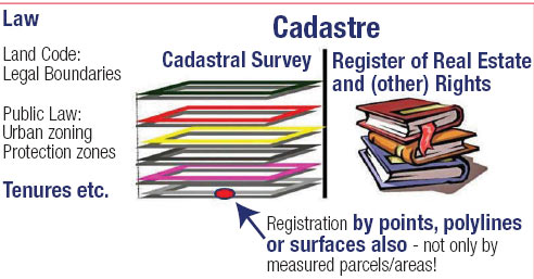
Figure 6-1 Cadastre 2014 data model approach for easy and fastregistration of tenures and holdings besides legal boundaries.
In Azerbaijan, especially in Baku (Figure 5-1), continuing degradation of the urban environment is going on due to the lack of a modern spatial planning system, missing master plans, or detailed plans for urban areas. Consequently, new construction is carried out under the pressure of market forces, basically without proper planning regulations. Even forced eviction for town development is common. In addition it is not quite clear who is responsible for the preparation of plans and issuing of permission for changes in land-use and building permits. State planning authorities still try to oversee planning issues that might be handled at the regional or municipal level (UNECE, Committee on Housing and Land Management 2007). Easy to apply building permits would help to increase security of the property. Stable and transparent procedures with defined planning horizons create security amongst owners and readiness for dynamic developments – altogether factors for the well-being of a developing and an industrial community.
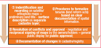
Figure 6-2 Fast Approach Cadastre Documentation toachieve basis for resolving pending land confl icts.
Sustainable land management needs cadastre as a pre-requisite
The fast approach cadastre as a central instrument of land management
Land management needs (in land reform, land consolidation, land use planning, etc.) as a pre-condition a sustainable base documentation of topology, topography, and property ownership or tenure. In cases where a reliable cadastre is missing, property remains unclear and SLM is hampered. So in the immediate aftermath of a con􀃀 ict the securing, restoration, or setup of land records is crucial. The cadastre follows as a consequence of where land records are available (Augustinus, C., Lewis, D., Leckie, S. 2007). Bad examples are easy to find, such as Kosovo or other Balkan countries. Even if a form of a cadastre system is in place but reliability and maintenance do not properly work an unclear property situation makes SLM very difficult, as shown above in Azerbaijan.
Loss of property and investments because of lacking transparency of public planning and unreliable cadastre will produce distrust in cadastral documentation. Problems will be created by illegal development and construction in restricted or endangered areas. Since 2007 in Kosovo municipal authorities have tried to regularize and legalize illegal constructions as a first step back to reliable land management systems as the cadastre (UNCESCR 2008).
Today the call for new tools is being heard. FIG is starting new initiatives as manifested in the publication Social Tenure Domain Model (STDM) (Lemmen, Chr. 2010). Unfortunately the data model achieved under this initiative is even more complicated than others. A more promising solution is the simplified application of the Cadastre 2014 approach concentrating on the registration of independent topics for the actual state of tenures, properties or holdings (Figure 6-1). No surveying is required but only the identi􀂿 cation of property or tenure based on points, polylines, or surfaces is needed. Efforts can be focused on the time consuming definition for regularization and legalization of informal and illegal tenures.
Comprehensive documentation in maintained digital cadastres of the actual existing legal situation of land following the principle of legal independence stated by Cadastre 2014 (Kaufmann, J., Steudler, D., 1998, page 18, Figure 3.18) will form a strong basis for SLM. The procedure for fast approach cadastre documentation (Figure 6-2) shall be defined as follows:
Step 1: Identification of property, house, or tenure on satellite or ortho-photo maps as point objects to create a preliminary land title. Definition of a surface description on a separate cadastre layer in the GIS by poly-lines accepting overlapping claims, rights, and disputes. The latter shall have a topological link to the point object forming the land title. The cadastre information obtained in such a way shall reflect the actual situation should it be legally approved or based on customary possession. It serves as a working base and needs stepwise improvement.
Step 2: Definition of procedures to formalize tenures based on clear documentation of spatial information. The procedures have to end up in a legally approved situation.
Step 3: Further steps focus on the resolution of conflicts and approval of the property and tenure situation reflected by the cadastre. As a very easy and effective procedure the negotiation and reciprocal signing of (ortho-) photo maps by the owners or holders shall be used. After this a general public display of the cadastral documentation achieved may lead to public approval.
Step 4: Having a clear documentation of the actual situation in the cadastre, the communal and state driven processes of formalization of ownership or holdings can start by legally approved land reform acts.
The cadastre of Public-Law Restrictions (PLR cadastre)
No one who owns land in most occupied areas of the world can simply use it as they wish. Owners have to comply with conditions laid down by governments and by other authorities. This means complying with a multitude of acts, ordinances and official restrictions – so-called public law restrictions on landownership rights (PLRs). These restrictions may be: Comprehensive development plans, zoning laws, building codes, impact fees and ordinances, lines of construction, lines defining the minimal distance to forests, cadastre of refuse dump locations, water protection zones, maps of hazard zones, etc. Until now, it has not been particularly easy to obtain all the information relevant to a specific parcel of land. Because a variety of authorities may be involved in the restrictions, a time-consuming trek from office to office is often needed. For this trouble the PLR Cadastre offers a solution by displaying authoritatively summarized the most important restrictions that apply to each land parcel (Dütschler, P., Bigler, M. 2006). The cadastre is to provide actual, correct and precise data of property rights and restrictions, to give evidence of the changes coming from the implementation of a planning process, and to serve as a basis for the next ‘dynamic planning cycle’. The reliability of property restrictions coming from planning periods has to be given.
Conclusions
The logical consequence of economic development–land consumption– substantiates the need for sustainable land management and cadastre. Successful attempts to direct or manage land consumption or land use can only run on a solid base of a well-maintaineddigital cadastre which represents the actual situation of property and tenure holdings as well as the Public- Law restrictions (PLR) on land.
For exceptional situations in southern, transition, and in post-conflict countries fast approach cadastre information following the Cadastre 2014 principles can be a crucial asset to document the existing and to restore a rightful situation using the tools of sustainable land management. The flexibility of handling not only legally approved but also informal and temporary objects by the use of the independent layer technology leads to an easy adjustment of documentation systems to the needs for the resolution of land problems.
– SLM based on fast documentation in cadastre allows quick reaction time of procedures on dynamic developments and improves security of property.
– SLM based on maintained digital cadastre following the boundary concept allows transparent workô€ƒ€ ows in the sense of good governance. – SLM and cadastre as well as PLR Cadastre should run in a symbiotic relationship for maximum effect. The wrong placement of settlements in endangered or hazardous areas, the loss of value through decreased life quality near traffic or airfields, etc., can be avoided. It is a fact that most planning processes are very time-consuming with up to 75% being devoted to data acquisition and preparation. Only 25% is left for effective planning work. With the new cadastre this ratio can be reversed to 25%:75% (Kaufmann, J. 2008). It will be a more demanding task of the surveyors to develop and implement sustainable land management activities pro-poor to help to resolve the social and environmental problems of the human community.
References
Andersson, B., Meha, M. 2003, Land Administration in Kosovo – Practice in Cooperation and Coordination, UN/ ECE-WPLA and FIG Com3 & Com7 Workshop on Spatial Information Management (SIM) for Sustainable Real Estate Market 2003, Athens, Greece.
Augustinus, C., Lewis, D., Leckie, S. 2007, A Post-Conflict Land Administration and Peace-Building Handbook, Series 1, UN-HABITAT, http://www.unhabitat.org/pmss/get ElectronicVersion.aspx?nr=2443&alt=1
Bertschi, M. 2002, Dimensionierung der Bauzonen: Eine Standortbestimmung aufgrund der Umsetzung von Art. 15 lit. B RPG; NSL – Network City and Landscape: DISP-Online, DISP 149 02/2002, SFIT Zurich, Switzerland – http://www.nsl.ethz. ch/index.php/en/ content/ view/full/96.
Dütschler, P., Bigler, M. 2006, Integration of Public-Law Restrictions into Cadastre, 23nd FIG International Congress, Munich, Germany.
Eggenberger, M., Stettler, D. 2008, Nutzungsreserven im Bestand – Konzeptstudie; Bundesamt für Raumentwicklung ARE, Bern, Switzerland (in German).
Government of the Republic of Kosovo, Ministry of Public Services 2008, Summary of Findings of the KCA Functional Review, Functional Review and Institutional Design of Ministries (FRIDOM) Project, Pristina, Kosovo.
Government of the Swiss Federation, Federal Directorate of Cadastral Surveying c/o Federal Office of Topography swisstopo, PLR Cadastre in brief, Berne-Wabern, http://www. swisstopo.admin.ch/internet/oerebk/ en/home/topics/about.html.
Guiet, Y. 2004, Le zonage des aires urbaines selon l’INSEE, Académie de Limoges – Lycée R. Loewy – La Souterraine (23300), http:// www.educreuse23.ac-limoges.fr/ loewy/siglim/cartes_ZAU.htm.
Kaufmann, J. 2008, The Boundary Concept: Land Management Opportunities for Sustainable Development Provided by the Cadastre 2014 Approach, FIG Working Week 2008, Stockholm, Sweden.
Kaufmann, J., Steudler, D. with Working Group 7.1 FIG Commission 7 1998, Cadastre 2014, A Vision for A Future Cadastral System, FIG Booklet, http://www.swisstopo. ch/􀂿 g-wg71/cad2014.htm.
Kohli, A. 1999, Measures to Prevent Scouring of Structures in Floodplains, Wasser & Boden, 51/3, 40-45 (in German).
Kohli, A. 2002, Renewal of the Network and the Realization of Orthometric Heights using GPS in Kosovo, 22nd FIG International Congress and ACSM-ASPRS Conference, Washington DC, USA.
Kohli, A. 2004, Reconstruction of a GIS-Cadastre in a developing Country, GeoSpatial World 2004 Congress, INTERGRAPH, Miami Beach, Florida, USA.
Kohli, A., Hager, W.H. 2001, Building Scour in Floodplains, Proceedings of the Institution of Civil Engineers: Water and Maritime Engineering 148, Issue 2, 61-80.
Lemmen, Chr. 2010, The Social Tenure Domain Model – A Pro-Poor Land Tool, FIG – GLTN – UN-HABITAT, International Federation of Surveyors (FIG) Copenhagen, Denmark.
Prud’homme, R., Dupuy, G. and Boret, D. 2004, The New Constraints of Urban Development, Institut Veolia Environnement, Report n°1, Paris, France.
Swiss Association for National Planning (VLP-ASPAN) 2004, Spatial Planning in Switzerland, Fact sheet, http://www.vlp-aspan.ch/content/ home/files/spatial_planning.pdf.
UN Committee on Economic, Social and Cultural Rights (UNCESCR) 2008, Property Return and Restitution: Kosovo, http://www2. ohchr.org/english/bodies/cescr/docs/ info-ngos/COHREUNMIK.pdf
UNECE-Committee on Housing and Land Management 2007, Land Administration Review: Azerbaijan, Programme of Work 2008-2009, Geneva, Switzerland.
|




 (14 votes, average: 1.86 out of 5)


Leave your response!