
Articles in the News Archives Category

UAVOS partners to advance HAPS technology
UAVOS has announced the successful completion of a test flight of Mira Aerospace’s High-Altitude PseudoSatellite (HAPS) ApusNeo 18, with UAVOS providing full engineering and technical support. One of the key objectives of the flight was to evaluate the jointly developed optoelectronic, gyro-stabilized aircraft POD (Payload Onboard Device) by obtaining …
SiTime takes on GNSS threats
SiTime Corporation has launched the Endura® temperature compensated oscillator (Super-TCXO®), ENDRTTT, for PNT applications. When GNSS signals are dropped due to unavailability or degradation – including signal jamming or extreme environmental conditions – holdover maintains timing stability locally to enable uninterrupted network operation. The ENDR-TTT Endura Super-TCXO provides up to 20x …
e-GEOS and Umbra partnership
e-GEOS and Umbra have signed a multi-year strategic agreement to jointly develop innovative geospatial intelligence solutions for customers worldwide.
The deal will combine the high revisit frequency, resolution and wide coverage offered by the First and Second Generation COSMO-SkyMed satellites – a SAR program of the Italian Space Agency and the …

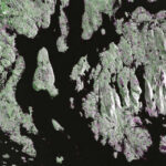
The findings of this study show the potential of using UAS-lidar as a sampling tool for estimating and monitoring AGB and other forest structural attributes.
Hastings Shamaoma
Department of Urban and Regional Planning, Copperbelt University, 21692 Kitwe, Zambia.
Paxie W. Chirwa
Forest Science Postgraduate Programme, Department of Plant and Soil Sciences, University of Pretoria, Private Bag X20, Hatfield, Pretoria …
German Orbital Systems to deploy Neuraspace STM
CubeSat manufacturer German Orbital Systems has contracted Neuraspace to secure the 16U pilot satellite, Pathfinder A, of ESA’s upcoming Celeste In-Orbit Demonstration constellation for LEO PNT (Low Earth Orbit Positioning, Navigation and Timing) with space traffic management (STM) capabilities. …
Iran prepares first Chabahar space launch
Iran plan to launch three Earth-observation satellites and carry out the first test launch from its new Chabahar space center, signaling a further expansion of its space program amid Western concerns over the dual-use nature of Iranian rocket technology. The Zafar-2, Paya and the second batch of Kosar imaging satellites …
New UltraCam Dragon 4.2 unveiled
Vexcel Imaging unveils the new UltraCam Dragon 4.2, the next evolution in hybrid aerial mapping technology. The new system features a significantly larger nadir and oblique image footprint, delivering a performance boost with 35% more flight line efficiency for faster data collection. Its powerful sensor suite combines two nadir cameras (RGB …
Study on GNSS authentication and security improvements
The E-GIANTS (European GNSS Improved Authentication Solutions) project was commissioned by the European Commission and technically supervised by EUSPA. The project responds to the growing threat posed by quantum computing to traditional cryptographic methods, which could compromise the security of GNSS services in the coming decade. The study highlights …
NASA-ISRO satellite sends first radar images of earth’s surface
The NISAR (NASA-ISRO Synthetic Aperture Radar) Earth-observing radar satellite’s first images of our planet’s surface are in, and they offer a glimpse of things to come as the joint mission between NASA and ISRO (Indian Space Research Organisation) approaches full science operations later this year. Images from …
SBG Systems expands its IMU line
SBG Systems has announced the upcoming release of the Pulse-20, a sub-miniature, industrial-grade Inertial Measurement Unit (IMU), which will be available before the end of the year.
Alongside the commercial availability of the Pulse-80, the company now offers a complete range of …


 (5.00 out of 5)