Articles in the Geodesy Category


The International Terrestrial Reference Frame (ITRF) “yy” is a realization of the International Terrestrial Reference System (ITRS), where the “yy” represents the year of the solutions. Since its fi rst realization in 1988, there have been many variations and additions in use of data types and changes in computational strategy.
International Earth …
Under the new Map Policy, it seems that India has decided to retain the old Indian Datum, which has been identified by “Everest”, for DSMs. The following geodetic definition issues and “specifi cations” are worth commenting:
Vintage – 1880s.
Name – On a recent enquiry, four SOI experts provided four different names. However, it cannot be “Everest”.
Spheroid …

GPS infrastructures that have been established in Malaysia are mainly served as a ground control stations for cadastral and mapping purposes. Another element that has not been utilised is the height component due to its low accuracy. Conventional levelling is still the preferred method by the land surveyors to determine the stations orthometric height (H) with a proven accuracy. Therefore, Department of Survey and Mapping Malaysia (DSMM) has embarked the Airborne Gravity Survey, with one of the objectives is to compute the local precise geoid for Malaysia within centimeter level of accuracy. With the availability of the precise geoid, the “missing” element of GPS system is solved.
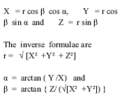
In continuation of the discussion about the ellipsoid and geoid in the earlier interaction through the Classroom feature, let us define the reference coordinate systems. Consider a vertical axis oriented towards the north pole as Z axis. The X axis is oriented towards the First point of Aries ?. The Y axis completes a right …

Maharashtra was the first state in the country to have a disaster management plan. It all started with the Latur Earthquake of 1993. As a part of response programme, the Maharashtra Emergency Earthquake Rehabilitation Project (MEERP) was launched the same year. This later led to the exercise of preparing a State Disaster Management Plan. The World Bank, United Nations Development Program (UNDP) as well as several bilateral donor agencies supported the initiative.

The 26th July 2005 floods in Mumbai, which caused widespread destruction, deaths and damage to property and infrastructure, have once again highlighted the importance of disaster mitigation and management using modern technology. Monitoring natural disasters like floods, earthquakes, volcanic eruptions, landslides, avalanches, cyclones, etc., with the ultimate aim of predicting them, and managing the rescue and rehabilitation operations during and after such calamities, have been discussed in various forums in the past. The devastating Latur earthquake of 1993, the Bhuj earthquake of 2001, the Orissa cyclone, and the recent tsunami after the Sumatra earthquake, which caused extensive damage in terms of human lives and property, have drawn the attention of the Indian scientific community to the immediate need of monitoring and managing such disasters in our country in the most effective, efficient and economic manner. Traditionally, maps are being used for this purpose, as an effective tool, since ancient times. However, with the introduction of computeraided techniques in map-making, and the space technology in surveying and mapping, the utility of geodetic and map data for this important activity has increased many-fold. However, a well-coordinated programme for optimum utilization of these important technological tools, resulting in efficient management of the disasters, still remains an elusive dream of administrators, scientists and technologists.

In Today’s world, with GPS, we can survey ellipsoidal heights (h) with 5-10 cm accuracy for geodetic control points on land and differential heights (?h) between well defi ned topographic features with relative accuracy of 1: 1Million or better. In few specific cases, this type of accuracy may require specially designed GPS surveys. In navigational mode, an instantaneous positional accuracy of about ± 5 m is easily possible. As these heights are the direct product of the GPS survey(s) and thus defi ned with respect to the ellipsoid, which is a time-invariant zero reference surface, they can be used without any reference to the geoid or Mean Sea Level (MSL). If we recall, in the classical surveys, e.g., triangulations and/or traverses, the vertical angles used to provide the “?h” and thus there will not be any need to convert them to orthometric heights.
IV MURALI KRISHNA Professor and Head, Centre for Spatial Information Technology, Jawaharlal Nehru Technological University, Hyderabad
iyyanki@icorg.org
Geodesy is science of the measurement and mapping of the earth’s surface. Satellite Geodesy in an orderly intensive manner started with the launch of the first artificial satellite SPUTNIK in October 1957. By the year 1964, many basic geodetic problems …


 (5.00 out of 5)