| Surveying | |
Brazil towards an effective cadastre with SIGEF
Brazil has developed the Land Management System – SIGEF: a cadastral digital platform for public and private lands, based on the Brazilian Public Records Act |
 |
|
 |
|
 |
|
A fundamental problem for the agrarian question in Brazil was and has been the lack of clear information of rural properties. The lack of Cadastre, according to international standards, is a notorious fragility over the time.
The description of rural properties, due to different interpretations of the object, is one of several reasons for land issues. In this situation is common the occurrence of differences between the current situation on the ground, and what is documented and formalized on Registry.
In this uncertainty scenario, over time, some situations occur such as:
– agrarian conflicts;
– misappropriation of public land;
– threats of territorial rights of traditional populations;
– environmental irregularity associated with criminal exploitation of natural resources and inability of accountability;
– reduction of productive potential.
However, this situation began to be changed with the advent the Law 10,267/2001, based on a solid concept of Cadastre. It established, at a glance: georeferencing as the method to represent land parcels; responsibilities of professionals and institutions for accountability; cadastral validation, called certification; the connection between the land institute and Registry for data exchange and mutual updates.
The certification process adopted and controlled by land institute, INCRA, established by Law 10,267/2001 and Decree 4,449/2002, consisted of a lengthy process that demanded the delivery of papers. In addition, INCRA, responsible agency for operate certification process, did not have sufficient operational capacity to answer the demand. The institute also did not have sufficient number of specialized professionals to be allocated in this exhaustive process created, regarded to manual information conference.
To streamline the certification process of rural properties, some actions should be taken to tackle the above problems, focusing on the construction of a land cadastre to identify, clearly and precisely, the domain boundaries and allow the sharing of such information to perform land management. In this way, is was developed a tool called Land Management System (Sistema de Gestão Fundiária – SIGEF), to manage the certification process with a full digital approach.
Objective
The purpose of this article is to show the approach applied to the cadastral surveyed data in Land Management System (SIGEF), in particular with respect to statement 3 of Cadastre 2014, regarding to the role of maps in Cadastre (Kaufmann and Steudler, 1998).
Cadastre 2014
Cadastre 2014 was a FIG activity report, published in 1998, that, over the years, has been translated into 28 languages and was a topic in many forums, panel discussions, roundtables and journal articles. It became a reference publication in many teaching and research institutions, triggered researches, promoted additional considerations on issues related to cadastral systems, including developments such as the “Cadastral Template” and in the field of “Spatial Data Infrastructures” (Steudler, 2014).
The document brought, also, an updated concept of Cadastre (Kaufmann and Steudler, 1998):
Cadastre 2014 is a methodically arranged public inventory of data concerning all legal land objects in a certain country or district, based on a survey of their boundaries. Such legal land objects are systematically identified by means of some separate designation. They are defined either by private or by public law. The outlines of the property, the identifier together with descriptive data, may show for each separate land object the nature, size, value and legal rights or restrictions associated with the land object.
The visionary publication made six statements about the Cadastre, presenting a clear vision for cadastral systems in the future as well as being an excellent review of the strengths and weaknesses of cadastral systems of that time (Kaufmann and Steudler, 1998).
In this paper, we will focus on the Statement 3, that regards to The Changing Role of Maps, defined by the following concept (Kaufmann and Steudler, 1998):
If future cadastral systems are to meet the requirements, the function of maps must be re- defined. Maps will lose the function of information storage. They will serve in future simply to represent information derived from data stored in databases.
The new possibilities of information technology will change the work of surveyors significantly. In the past, the ability to survey objects and to represent them in a reference system needed very special skills. One of the most important things was the craft to represent measured objects in a comprehensible map.
Then, the traditional Cadastral Cartography method consists in surveying and mapping. It is focused to locate the land objects and draw them on a map. Looking to the future, based on available technology, (Kaufmann and Steudler, 1998) proposed that:
The modern method of creating maps and documents out of data models would correspond to the flow: localization of objects by surveying, calculation of coordinates, modelling of objects according to data model, storage of objects in an information system, plotting of maps and creation of other products such as statistics, reports, documents, etc.
In this vision, the surveying is the way to product data that is formated in a model and stored in a land information system, from which the documents, statistics and other information are provided to society, according to its different needs:
Maps are created out of this model by using representation functions, operating plotters and drafting machines.
The distribution of information increasingly takes place with the help of data transfer possibilities. Geographic information is sent over the data highways. The Internet and its ability to facilitate worldwide data networks is playing an important role in the exchange of cadastral data. The exchange of data models will become common practice in the distribution of cadastral information.
This new procedure has several advantages:
• Flexibility in the representation of information of the data model. Type, scale, and content of a representation can be chosen according to the needs.
• The information is stored once and different products are derived from the same data.
• The digital model is easy to handle, and data representing the model cannot be destroyed physically as can traditional maps.
• Distribution and publication of cadastral information is easily possible with the help of the exchange of digital data models. (Kaufmann and Steudler, 1998) From now on, we will show how we proposed to achieve this goal, at the same time, abolishing the use of paper, implementing a digital cadastral data model and generating products form it.
The problem of reference
Following the concept of Cadastre seen previously, the purpose of a cadastral system is to identify legal land objects in a systematic way, with unique ID, and show, for each one, features like nature, size, value, associated rights and restrictions (Kaufmann and Steudler, 1998). This means, at a glance, representing these objects, aggregate information to them and report the result.
To represent this legal territorial object, maps are traditionally used. In this paradigm, as shown in the previous section, the measured objects are drawn on a map. In cartographic terms, this means that the data is collected in the field and converted to a plane of reference.
From this plane are obtained position and form (angles and distances) informations, for one or more parcels, considering their individual and relative situations. While we understand that the coordinates of the vertices that define the limits are the most important data, is easier to “end users” that measures of angles and distances be available, as them deals with the physical measures of the land and are not specialists in topography. So, the plane of reference is important for cadastral mapping to generate these measures. If a very general reference plane is used, distortion can be generated compromising the cadastral purpose.
Since 2003, when the georeferencing of rural properties was regulated (In Brazil, the Cadastre is not unique: there are urban cadastres, controlled by municipalities, and one rural land tenure Cadastre, regulated by Federal Government.), the projection used to represent the property was the UTM (Universal Transverse Mercator). The UTM projection has a longitudinal range of about 800 km (on equator). Ss any other projection, it is more suitable to represent areas compatible with its extent. In general, the greater compatibility between the reference plane and the spatial object, the greater proximity to surface measurements, due to distribution of the distortion by the extension. In UTM case there is a 1:2,500 reduction (0.9996) in the central meridian and the variation reaches 1 part in 1,000 from true scale at the Equator (SNYDER, 1987). For cases of rural properties that are located in central and extreme regions of projection, this is particularly harmful to obtain area and distances, so important to Cadastre.
Thus, one of the concerns when reviewing the cadastral data production process in Brazil, was the need to apply a new projection feature for territorial parcels, that was as close to reality as possible. It should allow to represent them individually, providing values compatible with the field and, at the same time, maintain such consistency considering neighbourhood. This should also lead to produce more intelligible information for the general public. This procedure was only possible, however, with an electronic tool capable to implement it.
SIGEF The Land Management System – SIGEF was, according to the regulations, developed to make the reception, validation, organization, regulation and availability of geo-referenced information limits of rural, public and private properties. Despite “Land Management” could be related to several applications, the focus of the system is to deal with land tenure.
At a glance, the system comprises the following features (INCRA, 2015b):
– Professional Accreditation to be able to submit cadastral data;
– System user authentication with digital certification, following patterns of Public Key Infrastructure (ICP-Brasil);
– Reception of standardized georeferenced data via internet;
– Fast, impersonal and automated validation, in accordance with the established technical parameters;
– Automatic generation of technical parts (plant and Legal Description), with the possibility of online authenticity check (via QR code or URL);
– Electronic management of requests concerning parts: certification, registration, dismemberment, merge, rectification and cancellation;
– Possibility of including updated information from the Land Registry (registration and owner) via the Internet, allowing an effective and fast synchronization;
– Management georeferencing service contracts with the government, with dedicated access to government agencies, companies, and tax officials;
– Public search of georeferenced parcels, requirements and credentialed surveyors;
– History of the parcels: access to requirements for each parcel, including dismemberment and merge possibility (not implemented yet).
The cadastral model of SIGEF
To provide measures with values closest as possible to the cadastral territorial object, it was proposed to use a Local Topographical Plane (PTL) for each parcel, obtained from a Local Geodetic System (SGL) (MDA, 2013c).
Although it is closer to the form of land object, the use of PTL has the inconvenience of not providing homogeneous measures in neighborhood situations. As each parcel has its own plane of reference, for the same boundary (shared between two parcels) we would have two different angle and distance values.
Thus, to meet the goals of consistent representation of cadastral land objects, considered individually and together, a new model was built, based not only in one reference, but in three: one for each required measure.
The Representation Model
According to the model applied, the land cadastral object would be represented by three elements: vertex, limit and parcel. For the purposes of this paper, we will discuss only the geometrical characteristics of these objects.
The definition of these land cadastral objects are described in regulations for the execution of the rural land survey. They are: Norma Técnica de Georreferenciamento de Imóveis Rurais – Technical Standard for Georeferencing of Rural Property (MDA, 2013c), Manual Técnico de Limites e Confrontações – Technical Manual for Limits Identification (MDA, 2013a) and Manual Técnico de Posicionamento – Technical Manual for Positioning (MDA, 2013b). The first one regards to definitions and general parameters, as reference system, professional accreditation, positioning precisions among others. The second one discusses in more detail how the professional identifies the boundaries in the field, from legal definitions. The third one addresses techniques used to determine the coordinates of identified limits, composing parcels. Another regulation, the SIGEF Manual, considers how to format, present and submit the data to the system, using its web interface (INCRA, 2015c).
Vertices
The third edition of Technical Standard for Georeferencing of Rural Property (MDA, 2013c) define vertex as:
the point where the rural property boundary line changes direction or where there is intersection of this line with any other boundary line of adjoining property.
Presenting the results of the survey, the credentialed surveyor must describe it using geodetic coordinates (φ, λ, h), referenced to the Brazilian Geodetic System (MDA, 2013c).
Upon receiving the data, after system validation and confirmation of the surveyor, the system stores the data in the database. At the vertex model, the geometry of the point is recorded using two different references: latitude, longitude and altitude (φ, λ, h), the same as the inserted data; and also converted into Geocentric Cartesian Coordinates, as defined (MDA, 2013c):
Geocentric Cartesian Coordinates are referenced to three orthogonal axes with origin at the center of mass of the earth, the “Z” axis oriented toward the Conventional Terrestrial Pole, the axis “X” in the mean direction of Greenwich meridian and the axis “Y” so as to make the system dextrorotatory.
All geometries are referenced to the GRS80 ellipsoid, used by the Geocentric Reference System for the Americas, in its 2000 realization – SIRGAS 2000 (IBGE, 2005).
Limits
The limits indicate the change of rights in the territory. Geometrically, according to MDA (2013c), the limits are described by line segments. Thus are not allowed curved elements, such as circular arcs, elliptical arcs, and others, in the description of boundaries of rural properties.
The limit is modeled with line geometry. The representation is also recorded with two different references: onedimensional latitude and longitude coordinates and another which corresponds to the calculated horizontal distance in space, from the geocentric Cartesian coordinates of the vertices (X, Y, Z).
Parcels
According to MDA (2013b), the rural property to be considered in georeferencing is that object of the domain title, that origins the registration. A certificate will be awarded to each land parcel and this will be described in a separate registration in the land registry.
For land parcel model, are also used two geospatial references. The geometric type used to represent it is the polygon. One geometry is recorded with geodetic longitude and latitude coordinates and another one in plane coordinates. To obtain the plane coordinates, two steps are performed. First is calculated a local geodetic system (MDA, 2013c):
The Local Geodetic System (SGL) is a Cartesian system that consists of three mutually orthogonal axes (e, n, u), where “n” axis points toward the north geodesic, the “e” axis points to the east direction and is perpendicular to the axis “n”, both contained in the topographical surface and the axis “u” coincides with the normal to the ellipsoid passing through the vertex selected as the system origin.
From this reference system are calculated the plane coordinates on the Local Topographical Plane (MDA, 2013b):
Local Cartesian coordinates are Cartesian coordinates defined in a Local Topographical Plane, perpendicular to the ellipsoidal normal and tangent to the Earth’s surface at the point of origin Local Geodetic System (SGL).

The coordinate values e, n, u are used to write the second geometry of the parcel on the database.
System outputs
Using the geospatial data presented, calculations are performed to obtain the data of area, angle (azimuth) and distance. Each calculation is performed using a particular reference, not the same for the three objects. Is important to note that the option to write the geospatial data using different spatial reference systems was made in implementation level. It would be possible to obtain the outputs with calculations on demand, but was considered that this could reduce performance over the time.
Distances
The base formula for obtaining the distance is as follows (MDA, 2013b):
Using the data model of limit, the straight line information corresponding to the horizontal distance has been already recorded. The value of distance is obtained using the st_length function (Postgis, 2015a), provided by PostGIS (PostGIS, 2015b), the spatial extension of PostgreSQL (POSTGRESQL, 2015), the database manager system used in SIGEF.
Angles
To calculate angles (azimuth) was applied the inverse problem of Puissant, which uses the given position of two vertices (φ, λ and φ ‘, λ’) and ellipsoidal parameters to determine ellipsoidal distance and its azimuth (MDA, 2013c).
Area
To obtain the value of area, the geometry used is that recorded in plane coordinates (e, n, u), over which is applied the st_area function, provided by Postgis database extension (POSTGIS, 2015a). This function implements the Gauss formula, the same set by georeferencing regulations (MDA, 2013c):
The area calculation must be performed by the Gauss formula, based on local Cartesian coordinates (e, n, u) and expressed in hectares.
Showing results
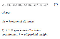
To provide the data, either individually or together, the different client applications (including SIGEF itself) use the geometries written in longitude and latitude. The use of the same reference system for all datasets is what allows direct access to the database and overlay them on the map (Figure 1), using softwares like QGIS (QGIS Development Team, 2014). The data follow the Simple Features Specification (SFS) standard of the Open Geospatial Consortium (OGC).
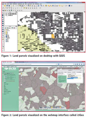
Another example of data providing is available in http://acervofundiario.incra. gov.br (INCRA, 2015a) which allows the overview of the surveyd parcels with other geospatial data themes, via WEB, available for public consultation (Figure 2).
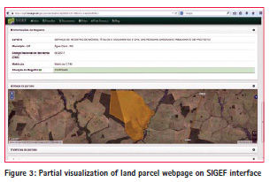
The parcel’s details webpage (Figure 3) provides its geometric characteristics, nature, legal situation (with or without confirmation of Registry), holder (one or many) and other information:
– parcel code, area, input date and status;
– georeferenced area: other parcels related to the same property are linked;
– holder/owner;
– registry: Registry Office name, municipality, code, property id and status;
– map, with imagery on background;
– vertices: code, geodetic coordinates, high, precisions and method used;
– limits: vertices linked, type, azymuth, length and neighbour description;
– applications opened by surveyors, like cancelling or Registry information updates;
– data download: shapefile, kml and csv formats;
– credentialed surveyor’s name and code, ART (code of technical responsibility document), link for parcel’s submission web page and date of the submission.
Documents
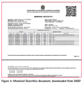
The functionality of document generation was developed to meet the need for communication with the end user. Also caters to the Registry, which still does not fully work in digital media.
The map provides geographical information of the parcels. The target parcel is shown with darker gray fill. The neighboring parcels are shown in light gray. The limits of the target parcel are represented in different line colors and thicknesses, according to the standard classification. The use of this symbology is aims to facilitate the interpretation of the map by the user. The Legal Description (called Memorial Descritivo, in portuguese) document contains the codes of the vertices, the numerical values of geodetic coordinates, heights, distances, azimuths and description of neighbours, informed by surveyor.
In both documents is generated a Quick Response Code (QR code), with the parcel unique code and the URL of your details page on the web, as shown above. This code may be used by optical readers connected to the internet, common in mobile devices such as smartphones. This functionality allows any user to check the documents and the current situation of the parcel without the need to enter codes manually, avoiding mistakes.

Conclusion
The aim of this paper was to show some characteristics of Land Management System (SIGEF) regarding to the statement 3 of Cadastre 2014 (Kaufmann and Steudler, 1998): that in future cadastral systems, with the utilization of information technologies, the direct drafting of objects on a map would be superseded by the creation of objects in an information system and, then, the data should be provided to different needs in different formats.
It was shown that, with the conceptual model implemented with SIGEF, was possible to receive cadastral surveyed data in one geospatial reference system and, using information technological resources, to transform and provide them to end users, according to their needs. These products include web pages, dynamic maps and documents. At the same time, due to the spatial references used, the measuring data provided are more accurate than if were used a conventional reference system for cadastral cartography.
Therefore, we conclude that the treatment given to cadastral data, implemented via SIGEF, accomplishes the statement number 3 of Cadastre 2014. This represents a breakthrough for Brazil in cadastral management.
However, we treated here of only one aspect of Brazilian Cadastre. Despite this and some other achievements, Brazil has big challenges to establish an effective Cadastre of its lands. Even using a tool like SIGEF to manage cadastral data, it is not possible to go further without facing and overwhelm some big challenges, like establish synergy among governmental agencies to perform, together, land governance using complementary cadastral concepts.
References
IBGE. (2005). Resolução 01/2005. Retrieved from ftp://geoftp.ibge. gov.br/documentos/ geodesia/ projeto_ mudanca_referencial_geodesico/ legislacao/rpr_01_25fev2005.pdf
INCRA. (2015a). Acervo Fundiário. Retrieved from http:// acervofundiario.incra.gov.br
INCRA. (2015b). Apresentaçao de Sistema de Gestão Fundiária, SIGEF. Retrieved from https://sigef. incra.gov.br/sobre/apresentacao/
INCRA. (2015c). SIGEF user manual. Retrieved from https://sigef.incra. gov.br/documentos/ manual/
Kaufmann, J. ve Steudler, D. (1998). Cadastre 2014 – A Vision for a Future Cadastral System, FIG Publication,44s, Berne, switzerland
MDA. (2013a). Manual Técnico de Limites e Confrontações. Retrieved from https://sigef.incra.gov.br/ static/documentos/manual_tecnico_ limites_confrontacoes_1ed.pdf
MDA. (2013b). Manual Técnico de Posicionamento. 1ª Edição. Retrieved from https://sigef.incra. gov.br/static/documentos/manual_ tecnico_posicionamento_1ed.pdf.
MDA. (2013c). Norma té cnica para georreferenciamento de imó veis rurais. 2a ediç ã o revisada. Retrieved from https:// sigef.incra.gov.br/static/documentos/ norma_tecnica_georreferenciamento_ imoveis_rurais_3ed.pdf
POSTGIS. (2015a). Postgis references. Retrieved from http://postgis.net/docs/ manual-1.5/ reference.html# Spatial_ Relationships_Measurements.
POSTGIS. (2015b). Retrieved from http://postgis.net/ POSTGRESQL. (2015). Retrieved from http://www.postgresql.org/
QGIS Development Team. (2014). QGIS Geographic Information System. Open Source Geospatial Foundation Project. Retrieved from http://qgis.osgeo.org.
Santos Jr, G. (2002). Utilizaç ã o da Integral Elí ptica para a Soluç ã o dos Problemas Direto e Inverso da Geodé sia.165 p. Master’s thesis. Postgraduate Course in Geodetic Sciences, Federal University of Paraná , Curitiba, Brazil.
Snyder, John P. (1987). Map Projections – A Working Manual. U.S. Geological Survey Professional Paper 1395. United States Government Printing Office, Washington, D.C.
Steudler, D. (2014). CADASTRE 2014 and beyond. Frederiksberg: The International Federation of Surveyors (FIG).
Acknowledgments
The authors wish to thank Luiz Fernando Barbosa Vital, Carlos Leite and George Silva, from ZNC Sistemas, and Luiz Pacheco Motta, Environmental Analyst on IBAMA. Also, the great group of Cadastral Surveyors of INCRA, that supported the georeferencing regulations deep review, required for implementing the digital process, and tested the system to guarantee its effectiveness. SIGEF could only become true with their knowledge and dedication.
The paper was presented at FIG Working Week 2015, Sofia, Bulgaria, 17-21 May 2015


 (2 votes, average: 4.50 out of 5)


Leave your response!