

In looking ahead at what milestones we may expect to see during 2008 in the world of GPS and GNSS it is easy to be caught at one of two extremes. The first extreme would be to make the mistake of the shortsighted person who in the late nineteenth century proposed that the US Patent Office should be closed because everything conceivable had already been invented. The other extreme would be to look ahead at the promise of new constellations…
Real-time traffic information to reach more than 83 million users
According to ABI Research, real-time traffic information services will reach more than 83 million paid or registered users worldwide by 2012. It sees three elements to the puzzle of providing truly useful traffic data for navigation systems.
First, the traffic data collection ecosystem is very complex. Infrastructure measurement systems (road sensors, cameras, radar, or loop sensors) are expensive and hard to install. A second challenge is traffic data aggregation. As the basic data becomes more available, the complex data derived from floating-car probes or predictive modeling will become the differentiator. But such data are harder to integrate into navigation routing. A third factor is market landscape. ABI Research expects INRIX and NAVTEQ/Traffic. com to become the two players in traffic data. www.gpsbusinessnews.com
Price war eminent in PND market
The PND (portable navigation device) market in Taiwan is likely to set into a price war due to the planned importation of ultra low-priced GPS devices from China. GPS makers in China plan to establish a ‘Triple Nine’ alliance, aiming to push sales of PNDs at prices below 999 yuan (US$135) in the China market. Vendors of Garmin, TomTom and Mio – stated that they are not concerned about the price competition, and will differentiate from China-made products with improved quality and innovative software. www.digitimes.com
Trimble technology for largest Road Project in Western Australia
Trimbles machine control systems and two-way data communications technology are being used for the construction of the New Perth Bunbury Highway—the single largest road project ever undertaken in Western Australia. The project is expected to be constructed over three years and will include the placement of approximately nine million cubic meters of soil to raise the road alignment. www.trimble.com
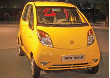
Nano effects
A historic moment.
For the automobile industry and for India too.
Tata unveiled small car Nano with a price tag of US$ 2,500.
When this ‘car for masses’ was promised, many did not believe.
Now it is a reality.
A revolutionary innovation.
An innovation that may change the life of millions.
GNSS technology too has this potential.
For imaginative applications and wider …

Ajay Seth,
Managing Director of Elcome Technologies on being acquired by Hexagon
What was the thought behind this acquisition?
The Indian market is growing very rapidly. From Hexagon’s perspective as well as the Indian point of view, we need to grow faster and this requires investment. Hexagon could help us achieve this …
January 2008
Institute of navigation national technical Meeting
January,28-30, 2007,
San Diego, California, USA
www.ion.org
February 2008
Mobile World congress 2008
February 11 – 14,
Barcelona, Spain
www.mobileworldcongress.com
Munich satellite navigation summit
19 – 21 February, 2008,
Residenz München, Germany
http://www.munich-satellitenavigationsummit.org/
GSDI-10 St.Augustine, Trinidad
February 25-29, 2008
http://www.gsdi.org/gsdi10/
NavtechGPS Seminars
February 25-29, 2008
New Orleans, LA
PWitt@navtechgps.com
March 2008
CeBIT
March 4-9,
Hannover Germany
www.cebit.de
WAlIS Forum 2008
March 12-14,
Perth, Western Australia
forum@walis.wa.gov.au
http://www.walis.wa.gov.au/forum
April 2008
GEO-SIBERIA 2008
April 22 – 24, 2008,
Novosibirsk , Russia,
strutz@sibfair.ru
http://geosiberia.sibfair.ru/eng/n
Space …
Galileo gets the go-ahead
Galileo finally got the go-ahead at the end of November when European nations involved in the project agreed to build the EUR 3.4 billion satellite navigation system. Thirty satellites will be placed in a mid-earth orbit and supported by ground stations in Italy and Germany. A third ground centre dedicated to civil protection, in particular in the area of maritime, air and rail security, will be based in Spain. This control centre is expected to take on further responsibilities as the Galileo system is developed. www.djnewswires.com/eu
Better ‘eye’ in space for Malaysia
Weighing 180 kg and with a 2.5 m resolution, Malaysia’s second remotesensing satellite shall provide images every 100 minutes. The RazakSAT is expected to be launched into space by the middle of this year. The satellite was jointly developed by Astronautic Technology (M) Sdn Bhd and Satellite Technology Research Center Initiative Co Ltd, South Korea. The cost of the RazakSAT programme is RM60 million. http://www.nst.com.my/
Mapping center of israel to launch Geography portal
The Mapping Center of Israel (MAPI) will soon launch a new national geography portal. The new site will have 120 information levels about land, outline plans, maps, trips, sites, aerial images, and historical maps. The maps on the site were created through collaboration with various ministries and will be free. www.globes.co.il


 (5.00 out of 5)