
3 – 4 March 2011
Delhi, India
km.nair.km@gmail.com
Link: http://www.hydrobharat.nic.in/HYDROIND_2011.htm
Tweet
April 27-29, 2011
Novosibirsk, Russia
sergeeva@sibfair.ru
Link: http://www.geo-siberia.ru/
New government programs focused on enhancing growth of civil and industrial construction sector and environmental economics regulation instigates a demand of Geographical Information Systems and newest equipment implementation and high qualified staff training in all geo-industry. For the first time International specialized forum “GEO-Siberia” joined the exhibition and Scientific Congress was held …

A brief outline of the three segments – User Segment, Space Segment and Ground Segment necessary for
implementation of an SBAS system over the Indian airspace. International Civil Aviation Organisation (ICAO) Member States have endorsed Global Satellite Navigation System (GNSS) as a primary future system for aviation. GNSS provides world-wide coverage for seamless aircraft navigation. Satellite transmission along with ground enhancement will enable the users to perform on-board position determination for enroute, terminal, non-precision and precision approaches.
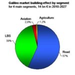
The global market for GNSS will grow significantly over the next decade, reaching some about €244 billion for the enabled GNSS market in 2020. GNSS market forecasting is of great interest to private and public GNSS stakeholders, for business and strategic planning and policymaking. According to the 2010 GNSS Market Monitoring report published by The European GNSS Agency (GSA), the global market for GNSS will grow significantly over the next decade, reaching some €244 billion for the enabled GNSS market in 2020. Delivery of GNSS devices will exceed one billion per year by 2020. Mobile location based services (LBS) and Road will be the market sectors with the highest revenue generation.

According to the report……, “Despite significant growth since 2006, significant untapped potential remains.” Would you like to elaborate on this?
According to the forecast based on available information sources and which involved several market experts, the global GNSS revenues are still expected to grow at a double digit CAGR in the 2010 – 2020 period. This growth will come from both new applications and expansion of current products and services. In terms of penetration, the biggest impact will come from LBS since GNSS is still only in a small portion of today’s mobile phones. Regarding new applications, there are countless examples such as ADAS (Advanced Driver Assistance Systems). As for GNSS R&D initiatives in the context of the EU 7FP program of the European Commission, being delegated to the GSA, there is a surge of GNSS technology projects proposing creative applications such as using combined radar and satellite navigation technologies to create maps of coastal areas. Advances in EGNOS and Galileo will accelerate these developments.
23-25 August 2011
Perth, Australia
walis@walis.wa.gov.au
Link to: http://www.isde7.net/
Tweet
15-18 May 2011
Abu Dhabi
Yun.Shi@iqpc.co.uk
Link to http://www.geospatialdefence.com/Event.aspx?id=415074
Tweet
9 – 11 May 2011
ANEC, Abu Dhabi
info@GSSForum.com
Link to: http://www.gssforum.com/
Tweet
Trimble buys Indian vehicle tracking, telematics company
Trimble releases eCognition version 8.64
NAVTEQ’s Global R&D Center now in Mumbai
Astrium bags billion dollar military contract
TopSURV 8 sets new industry standards
NavCom announces new capabilities
CORE Geospatial and DAT/EM announcement for DVP Users
RapidEye German mosaic now available
GMV announces the release of a Software GPS receiver for mass-market applications
SuperGeo develop dynamic bus info & transit system for Taichung City
Chronos leading a Consortium to develop a trusted service to detect and locate GPS jamming
u-blox launches LISA 3G modules optimized for M2M
NovAtel wins 2010 Alberta Export Award
Weihai Emergency Operations Centre Wins 2010 China City Information Application Award
GPS Mobile Mapping used to resolve Kosovo private property claims
ISRO to set up ground station to relay RS data DG’s satellite imagery for Chinese navigation companies China, Pakistan ink deal on remote sensing GeoEye to buy SPADAC for USD 46million PCI Geomatics to deliver GXL satellite processing system


 (5.00 out of 5)